Property Record
53671 Modelle Bryars Rd, Perdido, AL 36562
NEARBY LISTINGS FOR SALE OR LEASE
-
-
View all Perdido listings for sale on LoopNet.com
Property Detail
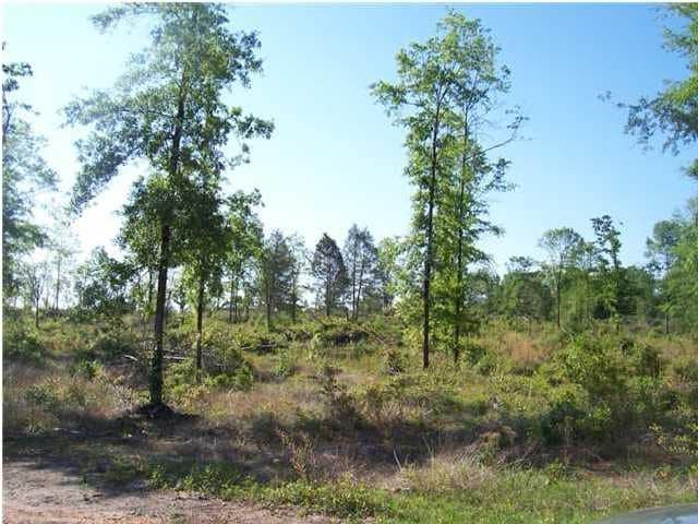
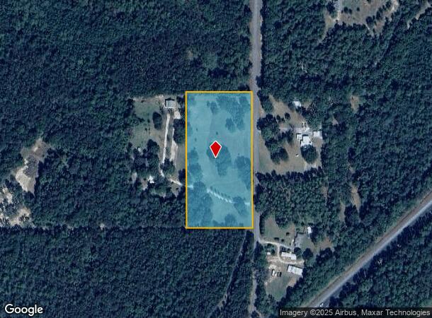
53671 Modelle Bryars Rd
Daphne-Fairhope-Foley, AL
Gulf Heights
15-08-33-0-000-003.006
645.7' X 313'(S) COM AT THE NW COR OF SEC 33 RUN TH S 1329.8', TH E 986.7' FOR THE POB TH RUN S 645.7', TH E 312'(S), TH N 64
Vacantlandnec
Baldwin
X
Alabama
01003C0225M
4.60 AC
2024
Baldwin County
2024
Mobile
010100
DEMOGRAPHICS near 53671 Modelle Bryars Rd
1 Mile
3 Mile
5 Mile
2024 Total Population
146
978
2,727
2029 Population
167
1,117
3,085
Pop Growth 2024-2029
+ 14.38%
+ 14.21%
+ 13.13%
Average Age
39
39
40
2024 Total Households
55
369
1,044
HH Growth 2024-2029
+ 14.55%
+ 13.55%
+ 12.64%
Median Household Inc
$41,428
$41,611
$43,172
Avg Household Size
2.50
2.50
2.50
2024 Avg HH Vehicles
2.00
2.00
2.00
Median Home Value
$166,666
$168,420
$165,384
Median Year Built
1986
1986
1987
Nearby Places
Map Layers
Map Styles
 Street
 Aerial
- Restaurants
- Banks
- Shops
- Fitness
- Groceries
Nearby Properties
Address
Land Use
TOTAL SIZE
Lot Size
Zoning
Address
Land Use
TOTAL SIZE
Lot Size
Zoning
3,604 SF
2.20 AC
Address
Land Use
TOTAL SIZE
Lot Size
Zoning
7,247 SF
1.30 AC
Address
Land Use
TOTAL SIZE
Lot Size
Zoning
7,575 SF
0.99 AC
Address
Land Use
TOTAL SIZE
Lot Size
Zoning
Address
Land Use
TOTAL SIZE
Lot Size
Zoning
4,808 SF
0.80 AC
Address
Land Use
TOTAL SIZE
Lot Size
Zoning
504 AC
Address
Land Use
TOTAL SIZE
Lot Size
Zoning
3,847 SF
5 AC
Address
Land Use
TOTAL SIZE
Lot Size
Zoning
1,560 SF
202 AC
Address
Land Use
TOTAL SIZE
Lot Size
Zoning
Address
Land Use
TOTAL SIZE
Lot Size
Zoning
224 AC
Address
Land Use
TOTAL SIZE
Lot Size
Zoning
1,972 SF
1.06 AC
Address
Land Use
TOTAL SIZE
Lot Size
Zoning
Address
Land Use
TOTAL SIZE
Lot Size
Zoning
Address
Land Use
TOTAL SIZE
Lot Size
Zoning
Address
Land Use
TOTAL SIZE
Lot Size
Zoning
Address
Land Use
TOTAL SIZE
Lot Size
Zoning
3,850 SF
0.40 AC
Address
Land Use
TOTAL SIZE
Lot Size
Zoning
Address
Land Use
TOTAL SIZE
Lot Size
Zoning
335 AC
Address
Land Use
TOTAL SIZE
Lot Size
Zoning
Address
Land Use
TOTAL SIZE
Lot Size
Zoning
392 AC
Address
Land Use
TOTAL SIZE
Lot Size
Zoning
316 AC
Address
Land Use
TOTAL SIZE
Lot Size
Zoning
192 AC
Address
Land Use
TOTAL SIZE
Lot Size
Zoning
Address
Land Use
TOTAL SIZE
Lot Size
Zoning
220 SF
6.40 AC
Address
Land Use
TOTAL SIZE
Lot Size
Zoning
Address
Land Use
TOTAL SIZE
Lot Size
Zoning
Address
Land Use
TOTAL SIZE
Lot Size
Zoning
Address
Land Use
TOTAL SIZE
Lot Size
Zoning
Address
Land Use
TOTAL SIZE
Lot Size
Zoning
307 AC
Address
Land Use
TOTAL SIZE
Lot Size
Zoning
448 SF
6.30 AC
The World's #1 Commercial Real Estate Marketplace
Connect with us
© 2026 CoStar Group
The information above has been obtained from sources believed reliable. While we do not doubt its accuracy we have not verified it and make no guarantee, warranty or representation about it. It is your responsibility to independently confirm its accuracy and completeness. Any projections, opinions, assumptions, or estimates used are for example only and do not represent the current or future performance of the property. The value of this transaction to you depends on tax and other factors which should be evaluated by your tax, financial, and legal advisors. You and your advisors should conduct a careful, independent investigation of the property to determine to your satisfaction the suitability of the property for your needs.