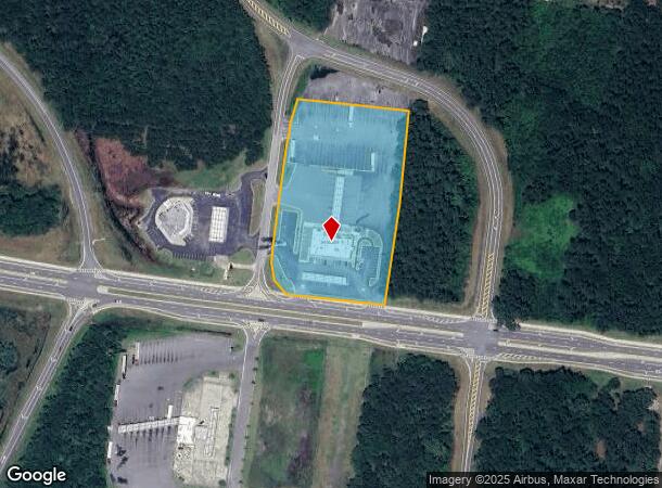
Property Record
5369 Laurel Island Pky, Kingsland, GA 31548

NEARBY LISTINGS FOR SALE OR LEASE
Property Detail
5369 Laurel Island Pky
St. Marys, GA
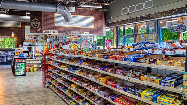
COMM (TRUCK STOP)/L COLERAIN
094-020A
Camden
Commercialnec
Georgia
2025
4.86 AC
2025
Brunswick/Kingsland
010406
Other Market Areas
8,840 SF
DEMOGRAPHICS near 5369 Laurel Island Pky
1 Mile
3 Mile
5 Mile
2024 Total Population
171
16,287
28,047
2029 Population
193
17,964
30,857
Pop Growth 2024-2029
+ 12.87%
+ 10.30%
+ 10.02%
Average Age
38
36
36
2024 Total Households
63
6,079
10,510
HH Growth 2024-2029
+ 14.29%
+ 10.40%
+ 10.12%
Median Household Inc
$62,500
$57,903
$61,467
Avg Household Size
2.60
2.60
2.60
2024 Avg HH Vehicles
2.00
2.00
2.00
Median Home Value
$289,285
$195,338
$199,162
Median Year Built
2005
1998
1997
Nearby Places
Map Layers
Map Styles
 Street
 Aerial
- Restaurants
- Banks
- Shops
- Fitness
- Groceries
PUBLIC TRANSPORTATION
AIRPORT
Jacksonville International
DRIVE
WALK
Distance
Jacksonville International
35 min
28.0 mi
Freight Ports
Georgia Ports - Brunswick
DRIVE
WALK
Distance
Georgia Ports - Brunswick
35 min
27.6 mi
SALE & LEASE HISTORY
LISTING DATE
SALE/LEASE

Sep 13, 2019
For Sale
Feb 08, 2018
For Lease
Nearby Properties
Address
Land Use
TOTAL SIZE
Lot Size
Zoning
Address
Land Use
TOTAL SIZE
Lot Size
Zoning
256,459 SF
38.54 AC
R-1
Address
Land Use
TOTAL SIZE
Lot Size
Zoning
184,547 SF
34.90 AC
R-1
Address
Land Use
TOTAL SIZE
Lot Size
Zoning
94,156 SF
74.30 AC
PD/R-1
Address
Land Use
TOTAL SIZE
Lot Size
Zoning
144,338 SF
35 AC
R-1
Address
Land Use
TOTAL SIZE
Lot Size
Zoning
79,447 SF
25 AC
PD/R-1
Address
Land Use
TOTAL SIZE
Lot Size
Zoning
74,567 SF
49 AC
R-1
Address
Land Use
TOTAL SIZE
Lot Size
Zoning
123,108 SF
11.83 AC
R-3
Address
Land Use
TOTAL SIZE
Lot Size
Zoning
3,879 SF
10.72 AC
PD/R-3
Address
Land Use
TOTAL SIZE
Lot Size
Zoning
8,544 SF
18.64 AC
C2
Address
Land Use
TOTAL SIZE
Lot Size
Zoning
16,598 SF
24.13 AC
PD/R-3
Address
Land Use
TOTAL SIZE
Lot Size
Zoning
2,833 SF
22.34 AC
PD/C2
Address
Land Use
TOTAL SIZE
Lot Size
Zoning
15,590 SF
0.71 AC
C-4
Address
Land Use
TOTAL SIZE
Lot Size
Zoning
51,948 SF
2.08 AC
C-4
Address
Land Use
TOTAL SIZE
Lot Size
Zoning
55,497 SF
1.68 AC
C-4
Address
Land Use
TOTAL SIZE
Lot Size
Zoning
16,768 SF
8.96 AC
R-3
Address
Land Use
TOTAL SIZE
Lot Size
Zoning
9,530 SF
10.71 AC
PD/R-3
Address
Land Use
TOTAL SIZE
Lot Size
Zoning
3,712 SF
4.12 AC
PD/C-2
Address
Land Use
TOTAL SIZE
Lot Size
Zoning
49,008 SF
1.61 AC
C-4
Address
Land Use
TOTAL SIZE
Lot Size
Zoning
66,000 SF
3.72 AC
R-3
Address
Land Use
TOTAL SIZE
Lot Size
Zoning
22,046 SF
4.50 AC
R-1
Address
Land Use
TOTAL SIZE
Lot Size
Zoning
19,600 SF
1.51 AC
C-4
Address
Land Use
TOTAL SIZE
Lot Size
Zoning
32,108 SF
1.23 AC
C-4
Address
Land Use
TOTAL SIZE
Lot Size
Zoning
43,213 SF
1.73 AC
C-4
Address
Land Use
TOTAL SIZE
Lot Size
Zoning
10,496 SF
20 AC
C-4
Address
Land Use
TOTAL SIZE
Lot Size
Zoning
87,500 SF
8.35 AC
I-L
Address
Land Use
TOTAL SIZE
Lot Size
Zoning
25 AC
R-1
Address
Land Use
TOTAL SIZE
Lot Size
Zoning
22,900 SF
3 AC
C-4
Address
Land Use
TOTAL SIZE
Lot Size
Zoning
7,620 SF
5 AC
C-4
Address
Land Use
TOTAL SIZE
Lot Size
Zoning
11,408 SF
6.37 AC
I-G
The World's #1 Commercial Real Estate Marketplace
Connect with us
© 2025 CoStar Group
The information above has been obtained from sources believed reliable. While we do not doubt its accuracy we have not verified it and make no guarantee, warranty or representation about it. It is your responsibility to independently confirm its accuracy and completeness. Any projections, opinions, assumptions, or estimates used are for example only and do not represent the current or future performance of the property. The value of this transaction to you depends on tax and other factors which should be evaluated by your tax, financial, and legal advisors. You and your advisors should conduct a careful, independent investigation of the property to determine to your satisfaction the suitability of the property for your needs.