Property Record
537 Chester St, Oakland, CA 94607
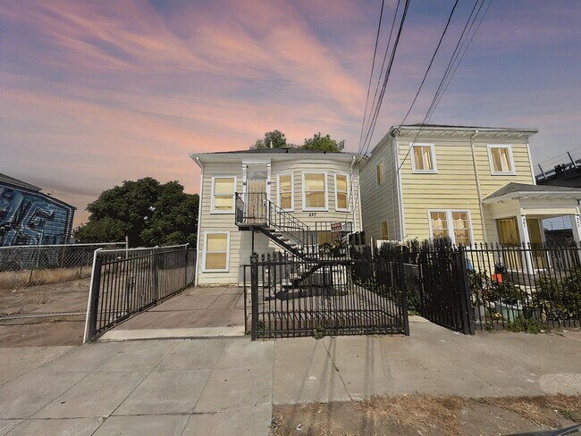

This Property Is For Sale
NEARBY LISTINGS FOR SALE OR LEASE
Property Detail
537 Chester St
Oakland-Hayward-Berkeley, CA
Oakland
004-0101-005-00
Alameda
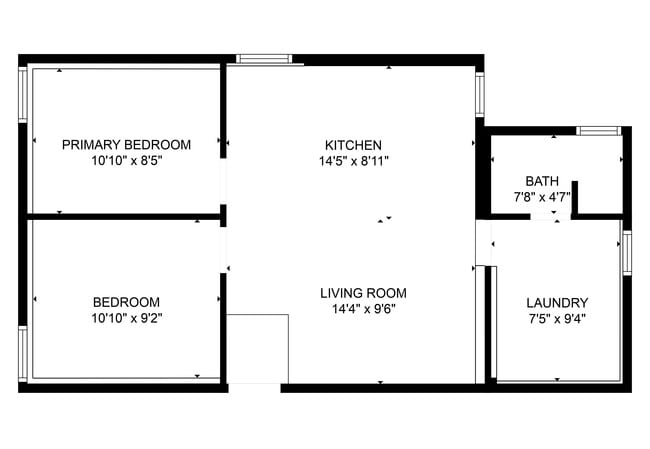
Duplex
California
X
0.07 AC
06001C0066H
West Oakland
742 SF
East Bay/Oakland
DEMOGRAPHICS near 537 Chester St
1 Mile
3 Mile
5 Mile
2024 Total Population
16,404
177,046
424,044
2029 Population
15,944
174,103
413,110
Pop Growth 2024-2029
(2.80%)
(1.66%)
(2.58%)
Average Age
39
41
40
2024 Total Households
5,907
81,270
173,634
HH Growth 2024-2029
(3.15%)
(1.81%)
(2.74%)
Median Household Inc
$71,021
$99,749
$101,758
Avg Household Size
2.30
2.00
2.20
2024 Avg HH Vehicles
1.00
1.00
1.00
Median Home Value
$815,775
$905,605
$1,048,538
Median Year Built
1965
1966
1957
Nearby Places
Map Layers
Map Styles
 Street
 Aerial
- Restaurants
- Banks
- Shops
- Fitness
- Groceries
PUBLIC TRANSPORTATION
TRANSIT/SUBWAY
West Oakland Station (Antioch to SFIA/Millbrae - Bay Area Rapid Transit (BART), Berryessa/North San Jose to Daly City - Bay Area Rapid Transit (BART), Daly City to Berryessa/North San Jose - Bay Area Rapid Transit (BART), Dublin/Pleasanton - Millbrae - Bay Area Rapid Transit (BART), Fremont - Daly City - Bay Area Rapid Transit (BART), Millbrae/SFIA to Antioch - Bay Area Rapid Transit (BART), Millbrae/SFO to Richmond - Bay Area Rapid Transit (BART), Pittsburg/Bay Point - San Francisco International - Bay Area Rapid Transit (BART), Richmond - Millbrae - Bay Area Rapid Transit (BART))
DRIVE
WALK
Distance
West Oakland Station (Antioch to SFIA/Millbrae - Bay Area Rapid Transit (BART), Berryessa/North San Jose to Daly City - Bay Area Rapid Transit (BART), Daly City to Berryessa/North San Jose - Bay Area Rapid Transit (BART), Dublin/Pleasanton - Millbrae - Bay Area Rapid Transit (BART), Fremont - Daly City - Bay Area Rapid Transit (BART), Millbrae/SFIA to Antioch - Bay Area Rapid Transit (BART), Millbrae/SFO to Richmond - Bay Area Rapid Transit (BART), Pittsburg/Bay Point - San Francisco International - Bay Area Rapid Transit (BART), Richmond - Millbrae - Bay Area Rapid Transit (BART))
0 min
1 min
0.1 mi
COMMUTER RAIL
Oakland (Capitol Corridor - Amtrak, Coast Starlight - Amtrak, San Joaquins - Amtrak)
DRIVE
WALK
Distance
Oakland (Capitol Corridor - Amtrak, Coast Starlight - Amtrak, San Joaquins - Amtrak)
4 min
1.8 mi
Emeryville (California Zephyr - Amtrak, Capitol Corridor - Amtrak, Coast Starlight - Amtrak, San Joaquins - Amtrak)
DRIVE
WALK
Distance
Emeryville (California Zephyr - Amtrak, Capitol Corridor - Amtrak, Coast Starlight - Amtrak, San Joaquins - Amtrak)
7 min
2.8 mi
AIRPORT
Metro Oakland International
DRIVE
WALK
Distance
Metro Oakland International
16 min
10.2 mi
San Francisco International
DRIVE
WALK
Distance
San Francisco International
34 min
21.8 mi
Freight Ports
Port of Oakland
DRIVE
WALK
Distance
Port of Oakland
3 min
1.5 mi
Nearby Properties
Address
Land Use
TOTAL SIZE
Lot Size
Zoning
Address
Land Use
TOTAL SIZE
Lot Size
Zoning
409,266 SF
1.76 AC
Address
Land Use
TOTAL SIZE
Lot Size
Zoning
1,028,501 SF
2.74 AC
Address
Land Use
TOTAL SIZE
Lot Size
Zoning
652,524 SF
1.38 AC
Address
Land Use
TOTAL SIZE
Lot Size
Zoning
617,980 SF
1.08 AC
Address
Land Use
TOTAL SIZE
Lot Size
Zoning
568,722 SF
0.99 AC
Address
Land Use
TOTAL SIZE
Lot Size
Zoning
767,791 SF
1.38 AC
Address
Land Use
TOTAL SIZE
Lot Size
Zoning
373,594 SF
16.16 AC
Address
Land Use
TOTAL SIZE
Lot Size
Zoning
488,781 SF
0.63 AC
Address
Land Use
TOTAL SIZE
Lot Size
Zoning
490,000 SF
1.44 AC
Address
Land Use
TOTAL SIZE
Lot Size
Zoning
432,352 SF
Address
Land Use
TOTAL SIZE
Lot Size
Zoning
525,866 SF
1.38 AC
Address
Land Use
TOTAL SIZE
Lot Size
Zoning
354,263 SF
4.06 AC
Address
Land Use
TOTAL SIZE
Lot Size
Zoning
358,014 SF
5.03 AC
Address
Land Use
TOTAL SIZE
Lot Size
Zoning
546,164 SF
6.02 AC
Address
Land Use
TOTAL SIZE
Lot Size
Zoning
328,427 SF
0.52 AC
Address
Land Use
TOTAL SIZE
Lot Size
Zoning
423,577 SF
1.04 AC
Address
Land Use
TOTAL SIZE
Lot Size
Zoning
405,462 SF
11.67 AC
Address
Land Use
TOTAL SIZE
Lot Size
Zoning
621,432 SF
1.31 AC
C
Address
Land Use
TOTAL SIZE
Lot Size
Zoning
288,796 SF
0.52 AC
Address
Land Use
TOTAL SIZE
Lot Size
Zoning
788,983 SF
1.63 AC
Address
Land Use
TOTAL SIZE
Lot Size
Zoning
0.73 AC
Address
Land Use
TOTAL SIZE
Lot Size
Zoning
703,758 SF
3.44 AC
Address
Land Use
TOTAL SIZE
Lot Size
Zoning
371,322 SF
1.62 AC
Address
Land Use
TOTAL SIZE
Lot Size
Zoning
240,633 SF
1.59 AC
Address
Land Use
TOTAL SIZE
Lot Size
Zoning
350,741 SF
1.08 AC
Address
Land Use
TOTAL SIZE
Lot Size
Zoning
344,273 SF
0.51 AC
Address
Land Use
TOTAL SIZE
Lot Size
Zoning
273,623 SF
1.44 AC
Address
Land Use
TOTAL SIZE
Lot Size
Zoning
224,160 SF
5.03 AC
Address
Land Use
TOTAL SIZE
Lot Size
Zoning
245,717 SF
0.65 AC
Address
Land Use
TOTAL SIZE
Lot Size
Zoning
303,063 SF
1.27 AC
The World's #1 Commercial Real Estate Marketplace
Connect with us
© 2025 CoStar Group
The information above has been obtained from sources believed reliable. While we do not doubt its accuracy we have not verified it and make no guarantee, warranty or representation about it. It is your responsibility to independently confirm its accuracy and completeness. Any projections, opinions, assumptions, or estimates used are for example only and do not represent the current or future performance of the property. The value of this transaction to you depends on tax and other factors which should be evaluated by your tax, financial, and legal advisors. You and your advisors should conduct a careful, independent investigation of the property to determine to your satisfaction the suitability of the property for your needs.