Property Record
5377 Quail Run Rd, Riverside, CA 92507
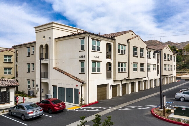


Property Detail
5377 Quail Run Rd
253-240-030
ACRES 30.90000000 ACREAGEQUALCODE ML LOTTYPE P PARCEL 2-P, 3, 4 MAPPLATB 156 MAPPLATP 050 SUBDIVISIONNAME PM 22871
Apartment
Riverside
A Areas with a 1% annual chance of flooding and a 26% chance of flooding over the life of a 30-year mortgage.
California
2024
30.90 AC
2025
Canyon Crest
042206
Inland Empire (California)
126,036 SF
Riverside-San Bernardino-Ontario, CA
NEARBY LISTINGS FOR SALE OR LEASE
DEMOGRAPHICS near 5377 Quail Run Rd
1 mile
3 mile
5 mile
2025 Total Population
8,814
80,343
244,270
2030 Population
9,073
82,321
249,673
Pop Growth 2025-2030
+ 2.94%
+ 2.46%
+ 2.21%
Average Age
36
35
36
2025 Total Households
3,704
25,378
73,887
HH Growth 2025-2030
+ 2.62%
+ 2.03%
+ 1.81%
Median Household Inc
$85,084
$84,100
$93,082
Avg Household Size
2.30
2.80
3.10
2025 Avg HH Vehicles
2.00
2.00
2.00
Median Home Value
$722,222
$676,324
$644,399
Median Year Built
1986
1982
1982
Nearby Places
Map Layers
Map Styles
 Street
 Aerial
Layers
 Traffic
 Biking
Places
Listings with unknown addresses are not visible on the map
- Restaurants
- Banks
- Shops
- Fitness
- Groceries
PUBLIC TRANSPORTATION
COMMUTER RAIL
Riverside-Downtown (91 Line - Southern California Regional Rail Authority (Metrolink), Inland Empire-Orange County Line - Southern California Regional Rail Authority (Metrolink), Riverside Line - Southern California Regional Rail Authority (Metrolink))
Drive
Walk
Distance
Riverside-Downtown (91 Line - Southern California Regional Rail Authority (Metrolink), Inland Empire-Orange County Line - Southern California Regional Rail Authority (Metrolink), Riverside Line - Southern California Regional Rail Authority (Metrolink))
8 min
4.2 mi
Riverside-Hunter Park/Ucr (Metrolink 91-Perris Valley Line - Metrolink Trains)
Drive
Walk
Distance
Riverside-Hunter Park/Ucr (Metrolink 91-Perris Valley Line - Metrolink Trains)
8 min
5.0 mi
AIRPORT
Ontario International
Drive
Walk
Distance
Ontario International
28 min
21.8 mi
Freight Ports
Port of Long Beach
Drive
Walk
Distance
Port of Long Beach
77 min
58.3 mi
Nearby Properties
Address
Land Use
TOTAL SIZE
Lot Size
Zoning
Address
Land Use
TOTAL SIZE
Lot Size
Zoning
1,012,995 SF
47.62 AC
Address
Land Use
TOTAL SIZE
Lot Size
Zoning
361,346 SF
18.17 AC
Address
Land Use
TOTAL SIZE
Lot Size
Zoning
95,047 SF
10.25 AC
Address
Land Use
TOTAL SIZE
Lot Size
Zoning
26.96 AC
R3
Address
Land Use
TOTAL SIZE
Lot Size
Zoning
302,116 SF
30.19 AC
RA
Address
Land Use
TOTAL SIZE
Lot Size
Zoning
449,040 SF
18.86 AC
BMP
Address
Land Use
TOTAL SIZE
Lot Size
Zoning
579,807 SF
30.23 AC
MP
Address
Land Use
TOTAL SIZE
Lot Size
Zoning
26,879 SF
16.27 AC
R3
Address
Land Use
TOTAL SIZE
Lot Size
Zoning
217,036 SF
1.66 AC
C2
Address
Land Use
TOTAL SIZE
Lot Size
Zoning
399,615 SF
24.31 AC
Address
Land Use
TOTAL SIZE
Lot Size
Zoning
37,010 SF
12.13 AC
Address
Land Use
TOTAL SIZE
Lot Size
Zoning
Address
Land Use
TOTAL SIZE
Lot Size
Zoning
209,734 SF
10.87 AC
R3
Address
Land Use
TOTAL SIZE
Lot Size
Zoning
36,010 SF
11.76 AC
R3
Address
Land Use
TOTAL SIZE
Lot Size
Zoning
663,613 SF
44.28 AC
Address
Land Use
TOTAL SIZE
Lot Size
Zoning
16.39 AC
R3
Address
Land Use
TOTAL SIZE
Lot Size
Zoning
134,474 SF
7.99 AC
C2
Address
Land Use
TOTAL SIZE
Lot Size
Zoning
253,025 SF
15.62 AC
R3
Address
Land Use
TOTAL SIZE
Lot Size
Zoning
509,422 SF
36.94 AC
Address
Land Use
TOTAL SIZE
Lot Size
Zoning
415,990 SF
5.16 AC
Address
Land Use
TOTAL SIZE
Lot Size
Zoning
172,944 SF
11.79 AC
20
Address
Land Use
TOTAL SIZE
Lot Size
Zoning
459,463 SF
17.38 AC
Address
Land Use
TOTAL SIZE
Lot Size
Zoning
28,548 SF
12.44 AC
Address
Land Use
TOTAL SIZE
Lot Size
Zoning
85,616 SF
18.64 AC
Address
Land Use
TOTAL SIZE
Lot Size
Zoning
26.48 AC
R3
The World's #1 Commercial Real Estate Marketplace
Connect with us
© 2026 CoStar Group
The information above has been obtained from sources believed reliable. While we do not doubt its accuracy we have not verified it and make no guarantee, warranty or representation about it. It is your responsibility to independently confirm its accuracy and completeness. Any projections, opinions, assumptions, or estimates used are for example only and do not represent the current or future performance of the property. The value of this transaction to you depends on tax and other factors which should be evaluated by your tax, financial, and legal advisors. You and your advisors should conduct a careful, independent investigation of the property to determine to your satisfaction the suitability of the property for your needs.