Property Record
5379 N Us Highway 1, Fort Pierce, FL 34946
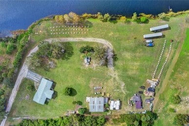
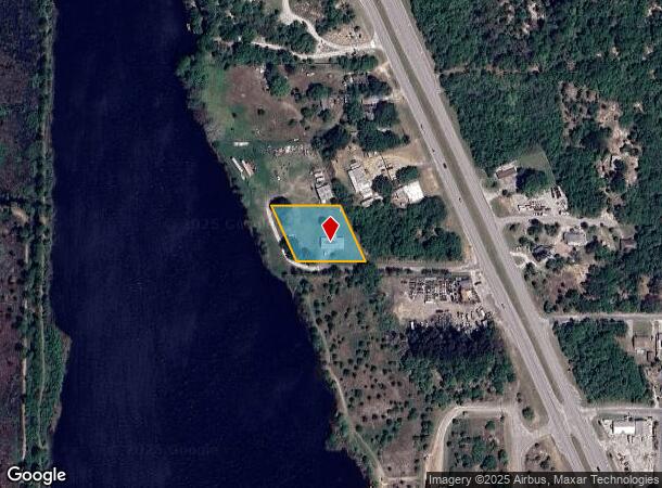
This Property Is For Sale
NEARBY LISTINGS FOR SALE OR LEASE
Property Detail
5379 N Us Highway 1
Port St Lucie, FL
L W Halbe Land
14-08-701-0001-5009
St Lucie
Sfr
Florida
X
1.01 AC
12061C0390J
Fort Pierce
1,496 SF
Port St Lucie/Fort Pierce
DEMOGRAPHICS near 5379 N Us Highway 1
1 Mile
3 Mile
5 Mile
2024 Total Population
345
19,272
58,780
2029 Population
412
23,091
69,630
Pop Growth 2024-2029
+ 19.42%
+ 19.82%
+ 18.46%
Average Age
41
48
47
2024 Total Households
140
8,321
24,871
HH Growth 2024-2029
+ 19.29%
+ 19.83%
+ 18.56%
Median Household Inc
$51,451
$53,998
$55,063
Avg Household Size
2.10
2.20
2.30
2024 Avg HH Vehicles
1.00
2.00
2.00
Median Home Value
$162,499
$197,973
$246,420
Median Year Built
1958
1987
1987
Nearby Places
- Restaurants
- Banks
- Shops
- Fitness
- Groceries
Nearby Properties
Address
Land Use
TOTAL SIZE
Lot Size
Zoning
Address
Land Use
TOTAL SIZE
Lot Size
Zoning
1,104 SF
299.94 AC
INSTITUTIO
Address
Land Use
TOTAL SIZE
Lot Size
Zoning
147,175 SF
56.96 AC
RS-2 - COU
Address
Land Use
TOTAL SIZE
Lot Size
Zoning
20.21 AC
HUTCH ISLA
Address
Land Use
TOTAL SIZE
Lot Size
Zoning
10.32 AC
Address
Land Use
TOTAL SIZE
Lot Size
Zoning
54,826 SF
353 AC
UTILITIES
Address
Land Use
TOTAL SIZE
Lot Size
Zoning
132,572 SF
17.39 AC
COMM GENRA
Address
Land Use
TOTAL SIZE
Lot Size
Zoning
123.19 AC
HUTCH ISLA
Address
Land Use
TOTAL SIZE
Lot Size
Zoning
216.28 AC
HUTCH ISLA
Address
Land Use
TOTAL SIZE
Lot Size
Zoning
38,158 SF
4.10 AC
CG - CO
Address
Land Use
TOTAL SIZE
Lot Size
Zoning
151,710 SF
7.30 AC
INDUSTRIAL
Address
Land Use
TOTAL SIZE
Lot Size
Zoning
76,130 SF
13.71 AC
INDUSTRIAL
Address
Land Use
TOTAL SIZE
Lot Size
Zoning
52.31 AC
HUTCH ISLA
Address
Land Use
TOTAL SIZE
Lot Size
Zoning
108,550 SF
8.51 AC
INDUSTRIAL
Address
Land Use
TOTAL SIZE
Lot Size
Zoning
37,090 SF
35.84 AC
PLANNED MX
Address
Land Use
TOTAL SIZE
Lot Size
Zoning
57,024 SF
10.45 AC
RM-9 COUNT
Address
Land Use
TOTAL SIZE
Lot Size
Zoning
924 SF
30.87 AC
RS-6
Address
Land Use
TOTAL SIZE
Lot Size
Zoning
70,000 SF
4.87 AC
INDUSTRIAL
Address
Land Use
TOTAL SIZE
Lot Size
Zoning
87,207 SF
17.16 AC
INSTITUTIO
Address
Land Use
TOTAL SIZE
Lot Size
Zoning
3.55 AC
HUTCH ISLA
Address
Land Use
TOTAL SIZE
Lot Size
Zoning
17,513 SF
325.01 AC
CONSERVATI
Address
Land Use
TOTAL SIZE
Lot Size
Zoning
242.35 AC
UTILITIES
Address
Land Use
TOTAL SIZE
Lot Size
Zoning
75.56 AC
Address
Land Use
TOTAL SIZE
Lot Size
Zoning
105.13 AC
CONSERVATI
Address
Land Use
TOTAL SIZE
Lot Size
Zoning
3,082 SF
15.24 AC
RMH-5 - CO
Address
Land Use
TOTAL SIZE
Lot Size
Zoning
2.18 AC
HUTCH ISLA
Address
Land Use
TOTAL SIZE
Lot Size
Zoning
160.93 AC
INDUSTRIAL
Address
Land Use
TOTAL SIZE
Lot Size
Zoning
50,635 SF
3.48 AC
COMM GENRA
Address
Land Use
TOTAL SIZE
Lot Size
Zoning
50,400 SF
18.98 AC
RS-6
Address
Land Use
TOTAL SIZE
Lot Size
Zoning
11,200 SF
1.72 AC
COMM GENRA
Address
Land Use
TOTAL SIZE
Lot Size
Zoning
1 AC
HUTCH ISLA
The World's #1 Commercial Real Estate Marketplace
Connect with us
© 2025 CoStar Group
The information above has been obtained from sources believed reliable. While we do not doubt its accuracy we have not verified it and make no guarantee, warranty or representation about it. It is your responsibility to independently confirm its accuracy and completeness. Any projections, opinions, assumptions, or estimates used are for example only and do not represent the current or future performance of the property. The value of this transaction to you depends on tax and other factors which should be evaluated by your tax, financial, and legal advisors. You and your advisors should conduct a careful, independent investigation of the property to determine to your satisfaction the suitability of the property for your needs.