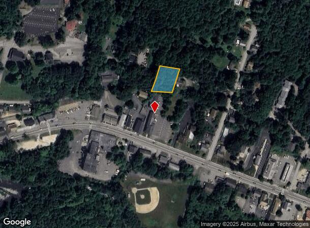
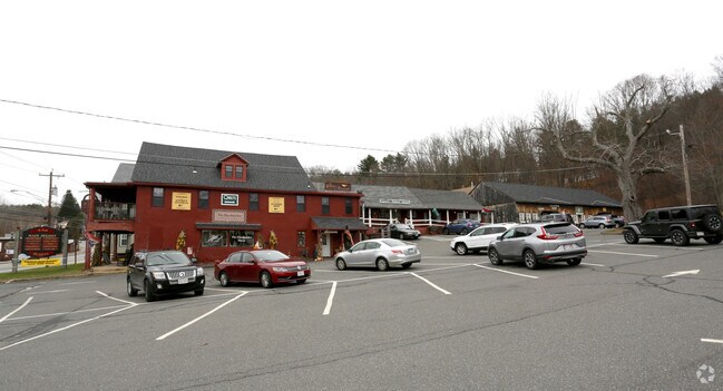
Property Record
538A Main St, Fiskdale, MA 01518

NEARBY LISTINGS FOR SALE OR LEASE
-
-
View all Fiskdale listings for lease on LoopNet.com
Property Detail
538A Main St
STUR-000415-000000-002421-000538A
Worcester
Nonbuildableland
Massachusetts
X
2421
09015C0025F
0.36 AC
2025
Outlying Worcester
2025
Boston
758103
Worcester, MA-CT
DEMOGRAPHICS near 538A Main St
1 Mile
3 Mile
5 Mile
2024 Total Population
2,261
8,318
25,919
2029 Population
2,258
8,334
25,815
Pop Growth 2024-2029
(0.13%)
+ 0.19%
(0.40%)
Average Age
40
42
42
2024 Total Households
902
3,301
10,423
HH Growth 2024-2029
(0.22%)
+ 0.15%
(0.44%)
Median Household Inc
$79,506
$102,027
$77,513
Avg Household Size
2.50
2.50
2.50
2024 Avg HH Vehicles
2.00
2.00
2.00
Median Home Value
$335,924
$368,198
$336,021
Median Year Built
1979
1980
1971
Nearby Places
- Restaurants
- Banks
- Shops
- Fitness
- Groceries
PUBLIC TRANSPORTATION
AIRPORT
Worcester Regional
DRIVE
WALK
Distance
Worcester Regional
37 min
23.2 mi
Freight Ports
Port of Davisville, RI
DRIVE
WALK
Distance
Port of Davisville, RI
95 min
74.5 mi
SALE & LEASE HISTORY
LISTING DATE
SALE/LEASE

Nov 20, 2018
For Lease
Nearby Properties
Address
Land Use
TOTAL SIZE
Lot Size
Zoning
Address
Land Use
TOTAL SIZE
Lot Size
Zoning
127,762 SF
19.28 AC
Address
Land Use
TOTAL SIZE
Lot Size
Zoning
102,966 SF
30.95 AC
Address
Land Use
TOTAL SIZE
Lot Size
Zoning
Address
Land Use
TOTAL SIZE
Lot Size
Zoning
208,444 SF
14.09 AC
Address
Land Use
TOTAL SIZE
Lot Size
Zoning
40,910 SF
25.36 AC
Address
Land Use
TOTAL SIZE
Lot Size
Zoning
Address
Land Use
TOTAL SIZE
Lot Size
Zoning
4,704 SF
76 AC
Address
Land Use
TOTAL SIZE
Lot Size
Zoning
189.22 AC
B
Address
Land Use
TOTAL SIZE
Lot Size
Zoning
105,660 SF
Address
Land Use
TOTAL SIZE
Lot Size
Zoning
93,552 SF
40.84 AC
Address
Land Use
TOTAL SIZE
Lot Size
Zoning
15,000 SF
2 AC
Address
Land Use
TOTAL SIZE
Lot Size
Zoning
5,024 SF
10.60 AC
Address
Land Use
TOTAL SIZE
Lot Size
Zoning
43,817 SF
3.17 AC
Address
Land Use
TOTAL SIZE
Lot Size
Zoning
55,530 SF
4.74 AC
Address
Land Use
TOTAL SIZE
Lot Size
Zoning
68,898 SF
49.02 AC
Address
Land Use
TOTAL SIZE
Lot Size
Zoning
52,255 SF
Address
Land Use
TOTAL SIZE
Lot Size
Zoning
36,220 SF
1.42 AC
Address
Land Use
TOTAL SIZE
Lot Size
Zoning
65,104 SF
9.60 AC
Address
Land Use
TOTAL SIZE
Lot Size
Zoning
4,888 SF
12.33 AC
Address
Land Use
TOTAL SIZE
Lot Size
Zoning
51,006 SF
10.54 AC
Address
Land Use
TOTAL SIZE
Lot Size
Zoning
73,136 SF
7.70 AC
Address
Land Use
TOTAL SIZE
Lot Size
Zoning
35,281 SF
2.68 AC
Address
Land Use
TOTAL SIZE
Lot Size
Zoning
28,371 SF
1.85 AC
Address
Land Use
TOTAL SIZE
Lot Size
Zoning
180,013 SF
6.84 AC
Address
Land Use
TOTAL SIZE
Lot Size
Zoning
39,576 SF
3.48 AC
Address
Land Use
TOTAL SIZE
Lot Size
Zoning
2,752 SF
0.22 AC
Address
Land Use
TOTAL SIZE
Lot Size
Zoning
10,678 SF
4.33 AC
Address
Land Use
TOTAL SIZE
Lot Size
Zoning
14,671 SF
1 AC
Address
Land Use
TOTAL SIZE
Lot Size
Zoning
10,148 SF
4.37 AC
Address
Land Use
TOTAL SIZE
Lot Size
Zoning
54,599 SF
5.37 AC
The World's #1 Commercial Real Estate Marketplace
Connect with us
© 2025 CoStar Group
The information above has been obtained from sources believed reliable. While we do not doubt its accuracy we have not verified it and make no guarantee, warranty or representation about it. It is your responsibility to independently confirm its accuracy and completeness. Any projections, opinions, assumptions, or estimates used are for example only and do not represent the current or future performance of the property. The value of this transaction to you depends on tax and other factors which should be evaluated by your tax, financial, and legal advisors. You and your advisors should conduct a careful, independent investigation of the property to determine to your satisfaction the suitability of the property for your needs.