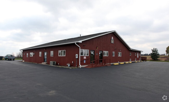
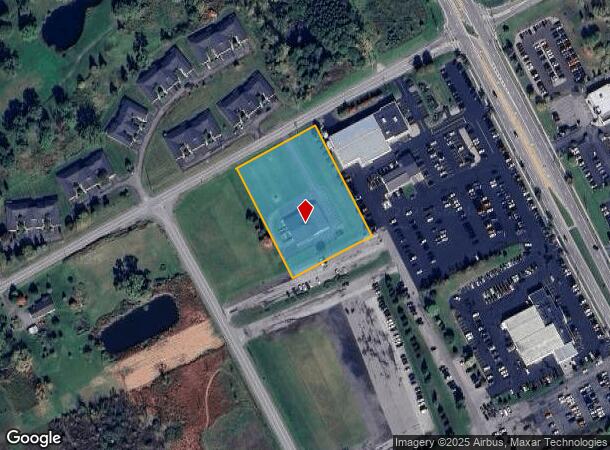
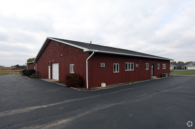
Property Record
5383 Thomas Rd, Canandaigua, NY 14424
NEARBY LISTINGS FOR SALE OR LEASE
Property Detail
5383 Thomas Rd
Rochester, NY
Ontario
322400-070-006-0001-062-411
New York
Animalhospitalvet
62.411
2025
2.10 AC
2024
Outlying Ontario County
050603
Rochester
7,488 SF
DEMOGRAPHICS near 5383 Thomas Rd
1 Mile
3 Mile
5 Mile
2024 Total Population
1,309
15,819
31,724
2029 Population
1,336
15,811
31,859
Pop Growth 2024-2029
+ 2.06%
(0.05%)
+ 0.43%
Average Age
45
42
43
2024 Total Households
674
6,973
13,509
HH Growth 2024-2029
+ 2.23%
(0.03%)
+ 0.47%
Median Household Inc
$81,250
$70,898
$75,847
Avg Household Size
1.90
2.20
2.20
2024 Avg HH Vehicles
2.00
2.00
2.00
Median Home Value
$149,444
$203,903
$203,604
Median Year Built
1996
1975
1980
Nearby Places
- Restaurants
- Banks
- Shops
- Fitness
- Groceries
PUBLIC TRANSPORTATION
AIRPORT
Frederick Douglass/Greater Rochester International
DRIVE
WALK
Distance
Frederick Douglass/Greater Rochester International
40 min
28.4 mi
Freight Ports
Albany, NY Port
DRIVE
WALK
Distance
Albany, NY Port
249 min
210.7 mi
Nearby Properties
Address
Land Use
TOTAL SIZE
Lot Size
Zoning
Address
Land Use
TOTAL SIZE
Lot Size
Zoning
56,880 SF
328.70 AC
AR1
Address
Land Use
TOTAL SIZE
Lot Size
Zoning
246,702 SF
30 AC
R1A
Address
Land Use
TOTAL SIZE
Lot Size
Zoning
266,624 SF
59.10 AC
R1B
Address
Land Use
TOTAL SIZE
Lot Size
Zoning
39,480 SF
10.90 AC
PUD
Address
Land Use
TOTAL SIZE
Lot Size
Zoning
75,357 SF
13.10 AC
MH
Address
Land Use
TOTAL SIZE
Lot Size
Zoning
800,000 SF
102 AC
IND M
Address
Land Use
TOTAL SIZE
Lot Size
Zoning
74,343 SF
88.50 AC
IND M
Address
Land Use
TOTAL SIZE
Lot Size
Zoning
146,058 SF
21.40 AC
R1B
Address
Land Use
TOTAL SIZE
Lot Size
Zoning
10,306 SF
29.60 AC
PUD
Address
Land Use
TOTAL SIZE
Lot Size
Zoning
4,519 SF
40 AC
M1
Address
Land Use
TOTAL SIZE
Lot Size
Zoning
14,220 SF
35.50 AC
M1
Address
Land Use
TOTAL SIZE
Lot Size
Zoning
48,000 SF
33.60 AC
IND
Address
Land Use
TOTAL SIZE
Lot Size
Zoning
38,181 SF
8.40 AC
MR
Address
Land Use
TOTAL SIZE
Lot Size
Zoning
38,181 SF
13.40 AC
MR
Address
Land Use
TOTAL SIZE
Lot Size
Zoning
7,735 SF
8.40 AC
03 - MULTI
Address
Land Use
TOTAL SIZE
Lot Size
Zoning
18,000 SF
2.35 AC
R1B
Address
Land Use
TOTAL SIZE
Lot Size
Zoning
12,052 SF
10.10 AC
R3
Address
Land Use
TOTAL SIZE
Lot Size
Zoning
38,000 SF
28 AC
IND
Address
Land Use
TOTAL SIZE
Lot Size
Zoning
115,200 SF
10 AC
PUD
Address
Land Use
TOTAL SIZE
Lot Size
Zoning
29,444 SF
7.30 AC
R3
Address
Land Use
TOTAL SIZE
Lot Size
Zoning
13,508 SF
2.40 AC
HRI
Address
Land Use
TOTAL SIZE
Lot Size
Zoning
193,692 SF
13 AC
M1
Address
Land Use
TOTAL SIZE
Lot Size
Zoning
95,406 SF
4.80 AC
R3
Address
Land Use
TOTAL SIZE
Lot Size
Zoning
20,675 SF
55.80 AC
RI
Address
Land Use
TOTAL SIZE
Lot Size
Zoning
3,660 SF
13.60 AC
R3
Address
Land Use
TOTAL SIZE
Lot Size
Zoning
5,320 SF
8.90 AC
PUD
Address
Land Use
TOTAL SIZE
Lot Size
Zoning
24,540 SF
23.10 AC
AR2
Address
Land Use
TOTAL SIZE
Lot Size
Zoning
108,722 SF
4.84 AC
M1
Address
Land Use
TOTAL SIZE
Lot Size
Zoning
37,432 SF
1.50 AC
HRI
Address
Land Use
TOTAL SIZE
Lot Size
Zoning
31,902 SF
1.80 AC
RI
The World's #1 Commercial Real Estate Marketplace
Connect with us
© 2025 CoStar Group
The information above has been obtained from sources believed reliable. While we do not doubt its accuracy we have not verified it and make no guarantee, warranty or representation about it. It is your responsibility to independently confirm its accuracy and completeness. Any projections, opinions, assumptions, or estimates used are for example only and do not represent the current or future performance of the property. The value of this transaction to you depends on tax and other factors which should be evaluated by your tax, financial, and legal advisors. You and your advisors should conduct a careful, independent investigation of the property to determine to your satisfaction the suitability of the property for your needs.