Property Record
5384 Highway 20 S, Covington, GA 30016
NEARBY LISTINGS FOR SALE OR LEASE
-
-
View all Covington listings for sale on LoopNet.com
Property Detail
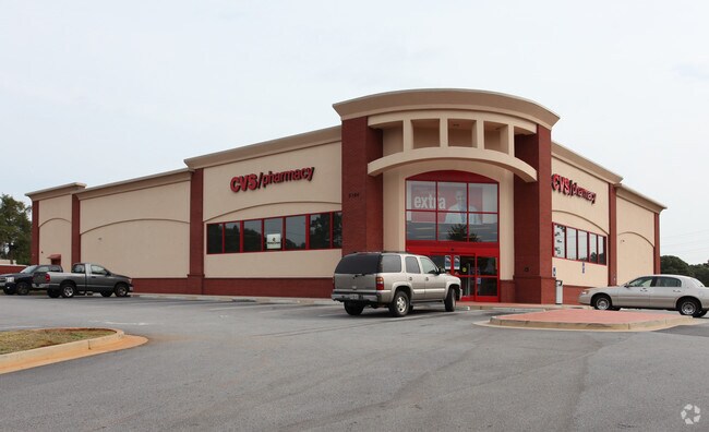
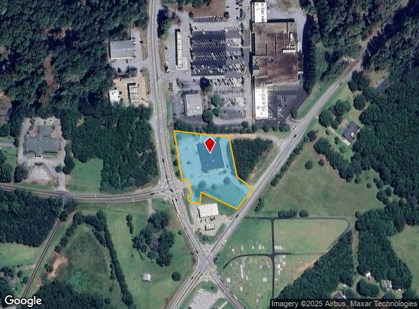
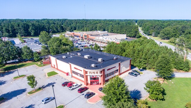
5384 Highway 20 S
Atlanta-Sandy Springs-Roswell, GA
Georgia 20 Corridor
0007A00000008000
1.89AC HWY 20
Drugstorepharmacycvswalgreens
Newton
X
Georgia
13247C0167D
78
2025
1.89 AC
2025
Lithonia/Conyers
100903
Atlanta
13,182 SF
DEMOGRAPHICS near 5384 Highway 20 S
1 Mile
3 Mile
5 Mile
2024 Total Population
2,817
23,683
62,985
2029 Population
3,017
25,274
67,680
Pop Growth 2024-2029
+ 7.10%
+ 6.72%
+ 7.45%
Average Age
39
40
39
2024 Total Households
1,004
8,259
21,777
HH Growth 2024-2029
+ 7.37%
+ 6.80%
+ 7.60%
Median Household Inc
$74,718
$80,824
$76,161
Avg Household Size
2.80
2.80
2.80
2024 Avg HH Vehicles
2.00
2.00
2.00
Median Home Value
$164,225
$210,209
$216,837
Median Year Built
1985
1992
1994
Nearby Places
Map Layers
Map Styles
 Street
 Aerial
- Restaurants
- Banks
- Shops
- Fitness
- Groceries
PUBLIC TRANSPORTATION
AIRPORT
Hartsfield - Jackson Atlanta International
DRIVE
WALK
Distance
Hartsfield - Jackson Atlanta International
48 min
31.8 mi
Freight Ports
Georgia Ports - Savannah
DRIVE
WALK
Distance
Georgia Ports - Savannah
265 min
232.1 mi
SALE & LEASE HISTORY
LISTING DATE
SALE/LEASE

Sep 20, 2023
For Sale
Nearby Properties
Address
Land Use
TOTAL SIZE
Lot Size
Zoning
Address
Land Use
TOTAL SIZE
Lot Size
Zoning
65,360 SF
75.51 AC
E6
Address
Land Use
TOTAL SIZE
Lot Size
Zoning
81,730 SF
17.98 AC
C1
Address
Land Use
TOTAL SIZE
Lot Size
Zoning
65,360 SF
30.63 AC
E6
Address
Land Use
TOTAL SIZE
Lot Size
Zoning
50,096 SF
4.19 AC
C1
Address
Land Use
TOTAL SIZE
Lot Size
Zoning
63,328 SF
10.67 AC
C2
Address
Land Use
TOTAL SIZE
Lot Size
Zoning
64,800 SF
16.19 AC
AR
Address
Land Use
TOTAL SIZE
Lot Size
Zoning
18,751 SF
4.14 AC
C2/OI
Address
Land Use
TOTAL SIZE
Lot Size
Zoning
6,000 SF
2.61 AC
C1
Address
Land Use
TOTAL SIZE
Lot Size
Zoning
19,363 SF
4 AC
AR
Address
Land Use
TOTAL SIZE
Lot Size
Zoning
17,558 SF
5.08 AC
AR/C1
Address
Land Use
TOTAL SIZE
Lot Size
Zoning
3,500 SF
0.85 AC
C1
Address
Land Use
TOTAL SIZE
Lot Size
Zoning
12,600 SF
1.33 AC
C2
Address
Land Use
TOTAL SIZE
Lot Size
Zoning
12,934 SF
2.37 AC
E3
Address
Land Use
TOTAL SIZE
Lot Size
Zoning
2,065 SF
15 AC
E2
Address
Land Use
TOTAL SIZE
Lot Size
Zoning
16,620 SF
10.86 AC
AR
Address
Land Use
TOTAL SIZE
Lot Size
Zoning
7,200 SF
1.07 AC
C2/C
Address
Land Use
TOTAL SIZE
Lot Size
Zoning
359.47 AC
A
Address
Land Use
TOTAL SIZE
Lot Size
Zoning
3,780 SF
78.28 AC
E2
Address
Land Use
TOTAL SIZE
Lot Size
Zoning
8,400 SF
6.03 AC
AR
Address
Land Use
TOTAL SIZE
Lot Size
Zoning
13,130 SF
1.20 AC
OI
Address
Land Use
TOTAL SIZE
Lot Size
Zoning
1,754 SF
1.14 AC
C2
Address
Land Use
TOTAL SIZE
Lot Size
Zoning
4,745 SF
0.63 AC
C1
Address
Land Use
TOTAL SIZE
Lot Size
Zoning
4,800 SF
1.41 AC
C1
Address
Land Use
TOTAL SIZE
Lot Size
Zoning
7,980 SF
5 AC
AR
Address
Land Use
TOTAL SIZE
Lot Size
Zoning
4.60 AC
OI
Address
Land Use
TOTAL SIZE
Lot Size
Zoning
8,400 SF
0.82 AC
C1
Address
Land Use
TOTAL SIZE
Lot Size
Zoning
4,200 SF
1.16 AC
C1
Address
Land Use
TOTAL SIZE
Lot Size
Zoning
5,491 SF
0.66 AC
AR&R1`
Address
Land Use
TOTAL SIZE
Lot Size
Zoning
6,400 SF
1 AC
C1
The World's #1 Commercial Real Estate Marketplace
Connect with us
© 2025 CoStar Group
The information above has been obtained from sources believed reliable. While we do not doubt its accuracy we have not verified it and make no guarantee, warranty or representation about it. It is your responsibility to independently confirm its accuracy and completeness. Any projections, opinions, assumptions, or estimates used are for example only and do not represent the current or future performance of the property. The value of this transaction to you depends on tax and other factors which should be evaluated by your tax, financial, and legal advisors. You and your advisors should conduct a careful, independent investigation of the property to determine to your satisfaction the suitability of the property for your needs.