Property Record
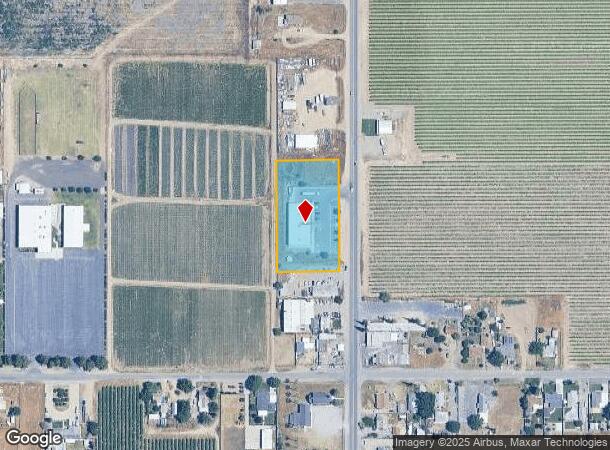
5385 S Elm Ave, Fresno, CA 93706
NEARBY LISTINGS FOR SALE OR LEASE
Property Detail
5385 S Elm Ave
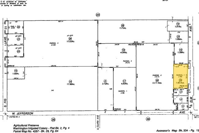
334-150-29
Parcel Map No 8035
Storebuilding
1.60 AC PARCEL 1 P/M 8035 BK 69 PG 16
X
Fresno
06019C2125H
California
2025
1.60 AC
2025
W Outlying Fresno County
001800
Fresno
9,100 SF
Fresno, CA
DEMOGRAPHICS near 5385 S Elm Ave
1 Mile
3 Mile
5 Mile
2024 Total Population
1,692
8,160
50,208
2029 Population
1,707
8,269
50,811
Pop Growth 2024-2029
+ 0.89%
+ 1.34%
+ 1.20%
Average Age
39
36
34
2024 Total Households
523
2,150
13,199
HH Growth 2024-2029
+ 0.76%
+ 1.30%
+ 1.15%
Median Household Inc
$85,937
$59,966
$43,492
Avg Household Size
3.10
3.40
3.50
2024 Avg HH Vehicles
3.00
2.00
2.00
Median Home Value
$384,482
$337,608
$246,481
Median Year Built
1963
1969
1971
Nearby Places
Map Layers
Map Styles
 Street
 Aerial
- Restaurants
- Banks
- Shops
- Fitness
- Groceries
PUBLIC TRANSPORTATION
AIRPORT
Fresno Yosemite International
DRIVE
WALK
Distance
Fresno Yosemite International
18 min
11.5 mi
Nearby Properties
Address
Land Use
TOTAL SIZE
Lot Size
Zoning
Address
Land Use
TOTAL SIZE
Lot Size
Zoning
855,000 SF
63.99 AC
IH
Address
Land Use
TOTAL SIZE
Lot Size
Zoning
226,597 SF
12.80 AC
M3
Address
Land Use
TOTAL SIZE
Lot Size
Zoning
291,527 SF
28.85 AC
M3
Address
Land Use
TOTAL SIZE
Lot Size
Zoning
670,680 SF
30.16 AC
IH
Address
Land Use
TOTAL SIZE
Lot Size
Zoning
343,038 SF
19.54 AC
AE20
Address
Land Use
TOTAL SIZE
Lot Size
Zoning
238,160 SF
18.77 AC
M3
Address
Land Use
TOTAL SIZE
Lot Size
Zoning
259,852 SF
56.49 AC
AE20
Address
Land Use
TOTAL SIZE
Lot Size
Zoning
198,436 SF
20.85 AC
M3
Address
Land Use
TOTAL SIZE
Lot Size
Zoning
409,374 SF
24.73 AC
SPLIT
Address
Land Use
TOTAL SIZE
Lot Size
Zoning
54,526 SF
5.88 AC
M3
Address
Land Use
TOTAL SIZE
Lot Size
Zoning
104,036 SF
6.73 AC
M3
Address
Land Use
TOTAL SIZE
Lot Size
Zoning
202,038 SF
10.83 AC
IH
Address
Land Use
TOTAL SIZE
Lot Size
Zoning
100,800 SF
5.16 AC
Address
Land Use
TOTAL SIZE
Lot Size
Zoning
364,000 SF
16.51 AC
M3
Address
Land Use
TOTAL SIZE
Lot Size
Zoning
384,000 SF
17.22 AC
M3
Address
Land Use
TOTAL SIZE
Lot Size
Zoning
47,704 SF
9.71 AC
M3
Address
Land Use
TOTAL SIZE
Lot Size
Zoning
160,351 SF
19.29 AC
M3
Address
Land Use
TOTAL SIZE
Lot Size
Zoning
188,274 SF
11 AC
M3
Address
Land Use
TOTAL SIZE
Lot Size
Zoning
93,704 SF
5.41 AC
M3
Address
Land Use
TOTAL SIZE
Lot Size
Zoning
201,600 SF
10.21 AC
M3
Address
Land Use
TOTAL SIZE
Lot Size
Zoning
299,040 SF
14.41 AC
M3
Address
Land Use
TOTAL SIZE
Lot Size
Zoning
144,000 SF
7.32 AC
M3
Address
Land Use
TOTAL SIZE
Lot Size
Zoning
38,398 SF
14.24 AC
M3
Address
Land Use
TOTAL SIZE
Lot Size
Zoning
47,784 SF
12.51 AC
M3
Address
Land Use
TOTAL SIZE
Lot Size
Zoning
116,964 SF
6.25 AC
SPLIT
Address
Land Use
TOTAL SIZE
Lot Size
Zoning
186,900 SF
9.48 AC
IH
Address
Land Use
TOTAL SIZE
Lot Size
Zoning
42,704 SF
4.95 AC
M3
Address
Land Use
TOTAL SIZE
Lot Size
Zoning
110,559 SF
5.76 AC
Address
Land Use
TOTAL SIZE
Lot Size
Zoning
329,056 SF
9.27 AC
M3
The World's #1 Commercial Real Estate Marketplace
Connect with us
© 2026 CoStar Group
The information above has been obtained from sources believed reliable. While we do not doubt its accuracy we have not verified it and make no guarantee, warranty or representation about it. It is your responsibility to independently confirm its accuracy and completeness. Any projections, opinions, assumptions, or estimates used are for example only and do not represent the current or future performance of the property. The value of this transaction to you depends on tax and other factors which should be evaluated by your tax, financial, and legal advisors. You and your advisors should conduct a careful, independent investigation of the property to determine to your satisfaction the suitability of the property for your needs.