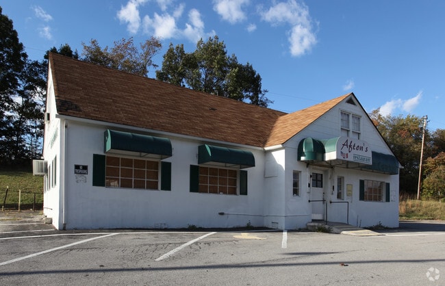
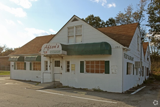
Property Record
5385 W Main St, Salem, VA 24153

Save to a Folder
{{folder.Name}}
{{folder.ListingIds.length}} Properties
{{folder.ListingIds.length}} Property
Create a New Folder
Property Detail
5385 W Main St
064.01-03-13
BOUNDARY SUR FOR PATEL OFF WEST MAIN ST
Hotelormotel
ROANOKE
C2S
Virginia
B and X Area of moderate flood hazard, usually the area between the limits of the 100-year and 500-year floods.
3.41 AC
2026
Southwest Roanoke
2026
Roanoke
010200
Roanoke, VA
4,858 SF
NEARBY LISTINGS FOR SALE OR LEASE
DEMOGRAPHICS near 5385 W Main St
1 mile
3 mile
5 mile
2025 Total Population
423
4,898
13,699
2030 Population
431
4,977
13,856
Pop Growth 2025-2030
+ 1.89%
+ 1.61%
+ 1.15%
Average Age
49
46
45
2025 Total Households
172
1,815
5,206
HH Growth 2025-2030
+ 2.33%
+ 1.82%
+ 1.21%
Median Household Inc
$69,999
$77,273
$82,597
Avg Household Size
2.20
2.30
2.40
2025 Avg HH Vehicles
2.00
2.00
2.00
Median Home Value
$262,222
$259,827
$261,488
Median Year Built
1981
1978
1977
Nearby Places
Map Layers
Map Styles
 Street
 Aerial
Layers
 Traffic
 Biking
Places
Listings with unknown addresses are not visible on the map
- Restaurants
- Banks
- Shops
- Fitness
- Groceries
PUBLIC TRANSPORTATION
AIRPORT
Roanoke/Blacksburg Regional (Woodrum Field)
Drive
Walk
Distance
Roanoke/Blacksburg Regional (Woodrum Field)
25 min
16.7 mi
Freight Ports
Virginia Port Authority - Richmond
Drive
Walk
Distance
Virginia Port Authority - Richmond
227 min
200.5 mi
Nearby Properties
Address
Land Use
TOTAL SIZE
Lot Size
Zoning
Address
Land Use
TOTAL SIZE
Lot Size
Zoning
265,000 SF
42.71 AC
AG3S
Address
Land Use
TOTAL SIZE
Lot Size
Zoning
78,701 SF
31.20 AC
C2S
Address
Land Use
TOTAL SIZE
Lot Size
Zoning
103,882 SF
93.53 AC
R1S
Address
Land Use
TOTAL SIZE
Lot Size
Zoning
375,302 SF
37.71 AC
PIN
Address
Land Use
TOTAL SIZE
Lot Size
Zoning
394,937 SF
25.15 AC
I2
Address
Land Use
TOTAL SIZE
Lot Size
Zoning
278,331 SF
134.03 AC
I2
Address
Land Use
TOTAL SIZE
Lot Size
Zoning
36,873 SF
29.63 AC
I2
Address
Land Use
TOTAL SIZE
Lot Size
Zoning
52,390 SF
8.77 AC
C2S
Address
Land Use
TOTAL SIZE
Lot Size
Zoning
50,708 SF
5.75 AC
C2S
Address
Land Use
TOTAL SIZE
Lot Size
Zoning
90,300 SF
20.18 AC
Address
Land Use
TOTAL SIZE
Lot Size
Zoning
123,361 SF
29.72 AC
I1
Address
Land Use
TOTAL SIZE
Lot Size
Zoning
6,300 SF
617.74 AC
AG3
Address
Land Use
TOTAL SIZE
Lot Size
Zoning
76,720 SF
4.90 AC
C2S
Address
Land Use
TOTAL SIZE
Lot Size
Zoning
65,496 SF
22.03 AC
I2
Address
Land Use
TOTAL SIZE
Lot Size
Zoning
63,192 SF
20 AC
PTD
Address
Land Use
TOTAL SIZE
Lot Size
Zoning
60,000 SF
8.45 AC
I2C
Address
Land Use
TOTAL SIZE
Lot Size
Zoning
41,600 SF
26.72 AC
I1
Address
Land Use
TOTAL SIZE
Lot Size
Zoning
26,766 SF
16.94 AC
PTD
Address
Land Use
TOTAL SIZE
Lot Size
Zoning
24,609 SF
18.65 AC
I2
Address
Land Use
TOTAL SIZE
Lot Size
Zoning
15,245 SF
3.44 AC
C1
Address
Land Use
TOTAL SIZE
Lot Size
Zoning
352.94 AC
PTD
Address
Land Use
TOTAL SIZE
Lot Size
Zoning
56,288 SF
13.28 AC
I2
Address
Land Use
TOTAL SIZE
Lot Size
Zoning
19,200 SF
7.34 AC
R1S
Address
Land Use
TOTAL SIZE
Lot Size
Zoning
76,584 SF
4.81 AC
I2
Address
Land Use
TOTAL SIZE
Lot Size
Zoning
11,152 SF
1 AC
C1
Address
Land Use
TOTAL SIZE
Lot Size
Zoning
14,988 SF
4.30 AC
C2S
Address
Land Use
TOTAL SIZE
Lot Size
Zoning
18,414 SF
6.63 AC
I1
Address
Land Use
TOTAL SIZE
Lot Size
Zoning
12,719 SF
2.63 AC
C2S
Address
Land Use
TOTAL SIZE
Lot Size
Zoning
1,536 SF
34.56 AC
I2
Address
Land Use
TOTAL SIZE
Lot Size
Zoning
24,835 SF
3.91 AC
C2S
The World's #1 Commercial Real Estate Marketplace
Connect with us
© 2026 CoStar Group
The information above has been obtained from sources believed reliable. While we do not doubt its accuracy we have not verified it and make no guarantee, warranty or representation about it. It is your responsibility to independently confirm its accuracy and completeness. Any projections, opinions, assumptions, or estimates used are for example only and do not represent the current or future performance of the property. The value of this transaction to you depends on tax and other factors which should be evaluated by your tax, financial, and legal advisors. You and your advisors should conduct a careful, independent investigation of the property to determine to your satisfaction the suitability of the property for your needs.