Property Record
539 Mccarty Rd, San Antonio, TX 78216

NEARBY LISTINGS FOR SALE OR LEASE
-
-
View all San Antonio listings for sale on LoopNet.com
Property Detail
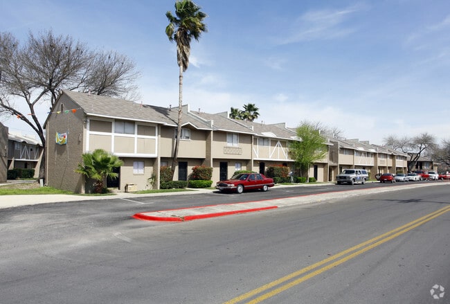
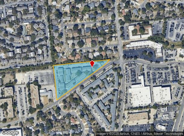
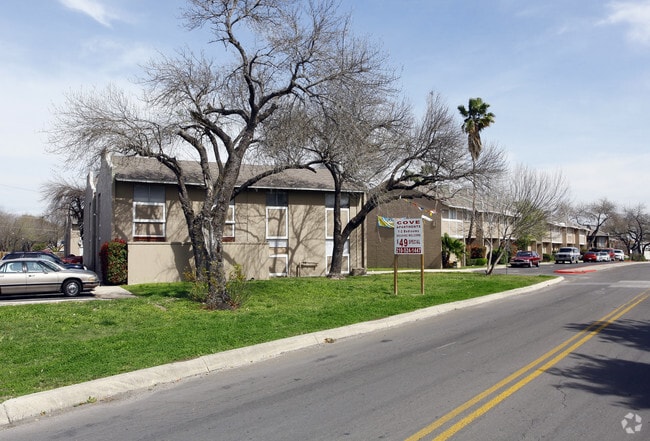
539 Mccarty Rd
San Antonio-New Braunfels, TX
North Star Hills Sub Un 5A Ncb
13824-001-0010
NCB 13824 BLK 1 LOT 1
Multifamilydwelling
Bexar
X
Texas
48029C0245G
1
2024
2.91 AC
2025
North Park
191202
San Antonio
62,696 SF
DEMOGRAPHICS near 539 Mccarty Rd
1 Mile
3 Mile
5 Mile
2024 Total Population
11,868
103,036
313,845
2029 Population
12,793
109,797
334,013
Pop Growth 2024-2029
+ 7.79%
+ 6.56%
+ 6.43%
Average Age
39
39
39
2024 Total Households
4,844
44,445
135,802
HH Growth 2024-2029
+ 8.09%
+ 6.85%
+ 6.70%
Median Household Inc
$52,687
$53,375
$57,363
Avg Household Size
2.40
2.30
2.20
2024 Avg HH Vehicles
2.00
2.00
2.00
Median Home Value
$272,201
$255,852
$275,224
Median Year Built
1967
1976
1978
Nearby Places
Map Layers
Map Styles
 Street
 Aerial
- Restaurants
- Banks
- Shops
- Fitness
- Groceries
PUBLIC TRANSPORTATION
COMMUTER RAIL
San Antonio Amtrak Station (Sunset Limited - Amtrak, Texas Eagle - Amtrak)
DRIVE
WALK
Distance
San Antonio Amtrak Station (Sunset Limited - Amtrak, Texas Eagle - Amtrak)
14 min
9.9 mi
AIRPORT
San Antonio International
DRIVE
WALK
Distance
San Antonio International
5 min
2.6 mi
Freight Ports
Calhoun Port
DRIVE
WALK
Distance
Calhoun Port
189 min
155.4 mi
Nearby Properties
Address
Land Use
TOTAL SIZE
Lot Size
Zoning
Address
Land Use
TOTAL SIZE
Lot Size
Zoning
557,078 SF
10.73 AC
Address
Land Use
TOTAL SIZE
Lot Size
Zoning
632,091 SF
27.82 AC
Address
Land Use
TOTAL SIZE
Lot Size
Zoning
338,255 SF
29.62 AC
Address
Land Use
TOTAL SIZE
Lot Size
Zoning
324,360 SF
15.05 AC
Address
Land Use
TOTAL SIZE
Lot Size
Zoning
246,000 SF
22.54 AC
Address
Land Use
TOTAL SIZE
Lot Size
Zoning
559,808 SF
24.43 AC
Address
Land Use
TOTAL SIZE
Lot Size
Zoning
46,451 SF
7.03 AC
Address
Land Use
TOTAL SIZE
Lot Size
Zoning
641,471 SF
41.71 AC
Address
Land Use
TOTAL SIZE
Lot Size
Zoning
317,537 SF
25.06 AC
Address
Land Use
TOTAL SIZE
Lot Size
Zoning
56,042 SF
14.60 AC
Address
Land Use
TOTAL SIZE
Lot Size
Zoning
223,288 SF
17.01 AC
Address
Land Use
TOTAL SIZE
Lot Size
Zoning
262,515 SF
6.38 AC
Address
Land Use
TOTAL SIZE
Lot Size
Zoning
506,058 SF
25.23 AC
Address
Land Use
TOTAL SIZE
Lot Size
Zoning
250,990 SF
4.89 AC
Address
Land Use
TOTAL SIZE
Lot Size
Zoning
353,293 SF
18.74 AC
Address
Land Use
TOTAL SIZE
Lot Size
Zoning
23,738 SF
4.84 AC
Address
Land Use
TOTAL SIZE
Lot Size
Zoning
152,676 SF
13.74 AC
Address
Land Use
TOTAL SIZE
Lot Size
Zoning
33,045 SF
23.63 AC
Address
Land Use
TOTAL SIZE
Lot Size
Zoning
314,264 SF
4.27 AC
Address
Land Use
TOTAL SIZE
Lot Size
Zoning
219,400 SF
6.16 AC
Address
Land Use
TOTAL SIZE
Lot Size
Zoning
360,836 SF
16.87 AC
Address
Land Use
TOTAL SIZE
Lot Size
Zoning
307,193 SF
7.18 AC
Address
Land Use
TOTAL SIZE
Lot Size
Zoning
402,327 SF
16.65 AC
Address
Land Use
TOTAL SIZE
Lot Size
Zoning
329,440 SF
14.89 AC
Address
Land Use
TOTAL SIZE
Lot Size
Zoning
223,381 SF
9.84 AC
Address
Land Use
TOTAL SIZE
Lot Size
Zoning
245,160 SF
15.10 AC
Address
Land Use
TOTAL SIZE
Lot Size
Zoning
392,678 SF
21.04 AC
Address
Land Use
TOTAL SIZE
Lot Size
Zoning
248,547 SF
3.30 AC
Address
Land Use
TOTAL SIZE
Lot Size
Zoning
74,510 SF
6.58 AC
Address
Land Use
TOTAL SIZE
Lot Size
Zoning
272,273 SF
13.62 AC
The World's #1 Commercial Real Estate Marketplace
Connect with us
© 2025 CoStar Group
The information above has been obtained from sources believed reliable. While we do not doubt its accuracy we have not verified it and make no guarantee, warranty or representation about it. It is your responsibility to independently confirm its accuracy and completeness. Any projections, opinions, assumptions, or estimates used are for example only and do not represent the current or future performance of the property. The value of this transaction to you depends on tax and other factors which should be evaluated by your tax, financial, and legal advisors. You and your advisors should conduct a careful, independent investigation of the property to determine to your satisfaction the suitability of the property for your needs.