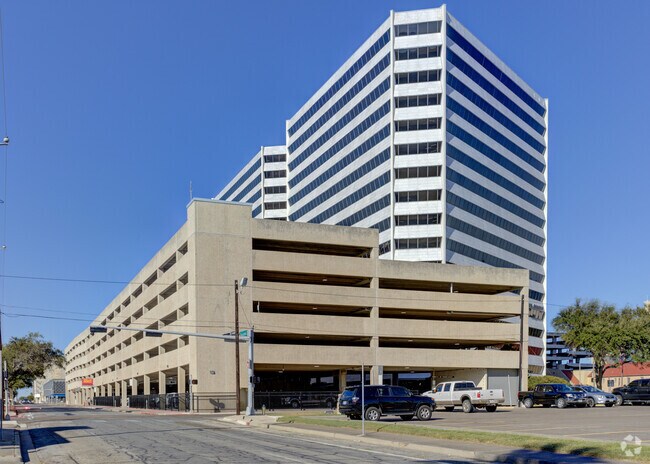
Property Record
539 N Carancahua St, Corpus Christi, TX 78401

NEARBY LISTINGS FOR SALE OR LEASE
Property Detail
539 N Carancahua St
Corpus Christi, TX
Bluff
196821
BLUFF PORTION LT 10-F BK 12
Commercialnec
Nueces
X
Texas
48355C0320G
10f
2024
0.43 AC
2025
CBD
006400
Corpus Christi
298,782 SF
DEMOGRAPHICS near 539 N Carancahua St
1 Mile
3 Mile
5 Mile
2024 Total Population
7,014
50,864
102,351
2029 Population
7,136
51,055
101,661
Pop Growth 2024-2029
+ 1.74%
+ 0.38%
(0.67%)
Average Age
43
40
39
2024 Total Households
2,651
18,790
37,752
HH Growth 2024-2029
+ 2.72%
+ 0.51%
(0.63%)
Median Household Inc
$30,351
$37,166
$41,422
Avg Household Size
1.90
2.50
2.60
2024 Avg HH Vehicles
1.00
1.00
2.00
Median Home Value
$139,843
$83,794
$98,526
Median Year Built
1971
1958
1958
Nearby Places
Map Layers
Map Styles
 Street
 Aerial
- Restaurants
- Banks
- Shops
- Fitness
- Groceries
PUBLIC TRANSPORTATION
AIRPORT
Corpus Christi International
DRIVE
WALK
Distance
Corpus Christi International
15 min
8.2 mi
Freight Ports
Port of Corpus Christi
DRIVE
WALK
Distance
Port of Corpus Christi
2 min
1.2 mi
SALE & LEASE HISTORY
LISTING DATE
SALE/LEASE

Sep 26, 2016
For Lease
Sep 25, 2016
For Lease
Aug 22, 2017
For Lease
Nearby Properties
Address
Land Use
TOTAL SIZE
Lot Size
Zoning
Address
Land Use
TOTAL SIZE
Lot Size
Zoning
382,448 SF
14.98 AC
Address
Land Use
TOTAL SIZE
Lot Size
Zoning
674,927 SF
10.54 AC
B4
Address
Land Use
TOTAL SIZE
Lot Size
Zoning
594,377 SF
29.96 AC
B5
Address
Land Use
TOTAL SIZE
Lot Size
Zoning
1 SF
62.73 AC
III
Address
Land Use
TOTAL SIZE
Lot Size
Zoning
24,217 SF
4.39 AC
B2
Address
Land Use
TOTAL SIZE
Lot Size
Zoning
370,000 SF
1.47 AC
B-2
Address
Land Use
TOTAL SIZE
Lot Size
Zoning
15.10 AC
I3
Address
Land Use
TOTAL SIZE
Lot Size
Zoning
1 SF
13.71 AC
B5
Address
Land Use
TOTAL SIZE
Lot Size
Zoning
302,344 SF
5 AC
Address
Land Use
TOTAL SIZE
Lot Size
Zoning
392,617 SF
2.20 AC
B2
Address
Land Use
TOTAL SIZE
Lot Size
Zoning
131,533 SF
23.24 AC
I3
Address
Land Use
TOTAL SIZE
Lot Size
Zoning
1 SF
10.53 AC
I2
Address
Land Use
TOTAL SIZE
Lot Size
Zoning
10,000 SF
35.96 AC
R1B
Address
Land Use
TOTAL SIZE
Lot Size
Zoning
72,106 SF
1.96 AC
B-5
Address
Land Use
TOTAL SIZE
Lot Size
Zoning
11.03 AC
I3
Address
Land Use
TOTAL SIZE
Lot Size
Zoning
75,120 SF
1.93 AC
B2
Address
Land Use
TOTAL SIZE
Lot Size
Zoning
65,301 SF
7.37 AC
B-4
Address
Land Use
TOTAL SIZE
Lot Size
Zoning
177,545 SF
7.75 AC
B2
Address
Land Use
TOTAL SIZE
Lot Size
Zoning
52,121 SF
27.73 AC
Address
Land Use
TOTAL SIZE
Lot Size
Zoning
74,261 SF
4.44 AC
R1B
Address
Land Use
TOTAL SIZE
Lot Size
Zoning
361,000 SF
2.20 AC
B6PUD2
Address
Land Use
TOTAL SIZE
Lot Size
Zoning
13,773 SF
28.82 AC
R1B
Address
Land Use
TOTAL SIZE
Lot Size
Zoning
103,628 SF
2.61 AC
Address
Land Use
TOTAL SIZE
Lot Size
Zoning
145,296 SF
1.21 AC
B6
Address
Land Use
TOTAL SIZE
Lot Size
Zoning
186,106 SF
6.54 AC
B1
Address
Land Use
TOTAL SIZE
Lot Size
Zoning
94,600 SF
9.29 AC
R2
Address
Land Use
TOTAL SIZE
Lot Size
Zoning
129,210 SF
11.63 AC
R1B
Address
Land Use
TOTAL SIZE
Lot Size
Zoning
315,038 SF
1.38 AC
B-6
Address
Land Use
TOTAL SIZE
Lot Size
Zoning
108,064 SF
6.09 AC
R1A
Address
Land Use
TOTAL SIZE
Lot Size
Zoning
73,595 SF
2.63 AC
B5
The World's #1 Commercial Real Estate Marketplace
Connect with us
© 2026 CoStar Group
The information above has been obtained from sources believed reliable. While we do not doubt its accuracy we have not verified it and make no guarantee, warranty or representation about it. It is your responsibility to independently confirm its accuracy and completeness. Any projections, opinions, assumptions, or estimates used are for example only and do not represent the current or future performance of the property. The value of this transaction to you depends on tax and other factors which should be evaluated by your tax, financial, and legal advisors. You and your advisors should conduct a careful, independent investigation of the property to determine to your satisfaction the suitability of the property for your needs.