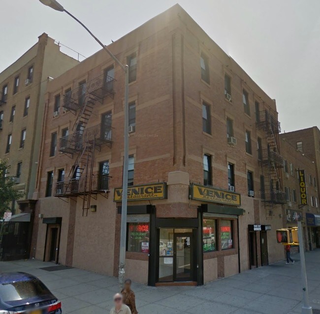
Property Record
539 Wales Ave, Bronx, NY 10455
NEARBY LISTINGS FOR SALE OR LEASE
Property Detail
539 Wales Ave
02580-0024
Bronx
Apartment
New York
X
24
3604970083F
0.06 AC
2024
North New York
2025
Westchester/So Connecticut
003500
New York-Jersey City-White Plains, NY-NJ
7,828 SF
DEMOGRAPHICS near 539 Wales Ave
1 Mile
3 Mile
5 Mile
2024 Total Population
143,477
1,136,214
2,709,022
2029 Population
133,963
1,054,528
2,522,308
Pop Growth 2024-2029
(6.63%)
(7.19%)
(6.89%)
Average Age
36
38
40
2024 Total Households
50,059
421,709
1,069,921
HH Growth 2024-2029
(7.41%)
(7.72%)
(7.23%)
Median Household Inc
$28,440
$40,549
$59,425
Avg Household Size
2.70
2.50
2.40
2024 Avg HH Vehicles
.00
.00
.00
Median Home Value
$396,179
$632,775
$748,791
Median Year Built
1968
1955
1952
Nearby Places
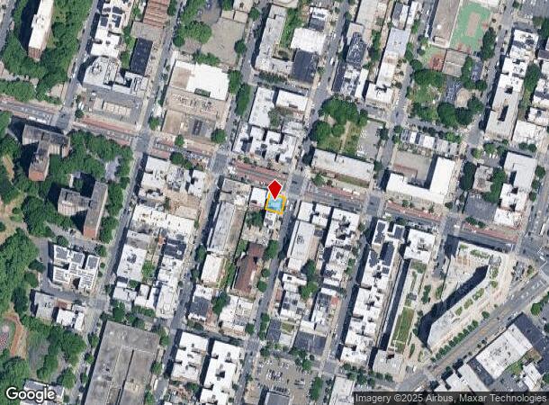
Map Layers
Map Styles
 Street
 Aerial
- Restaurants
- Banks
- Shops
- Fitness
- Groceries
PUBLIC TRANSPORTATION
TRANSIT/SUBWAY
Jackson Avenue (2 - New York MTA Subway (The Subway), 5 - New York MTA Subway (The Subway))
DRIVE
WALK
Distance
Jackson Avenue (2 - New York MTA Subway (The Subway), 5 - New York MTA Subway (The Subway))
1 min
5 min
0.3 mi
East 143 Street-St Marys Street (6 - New York MTA Subway (The Subway))
DRIVE
WALK
Distance
East 143 Street-St Marys Street (6 - New York MTA Subway (The Subway))
1 min
7 min
0.4 mi
East 149 Street (6 - New York MTA Subway (The Subway))
DRIVE
WALK
Distance
East 149 Street (6 - New York MTA Subway (The Subway))
1 min
7 min
0.4 mi
3 Avenue-149 Street (2 - New York MTA Subway (The Subway), 5 - New York MTA Subway (The Subway))
DRIVE
WALK
Distance
3 Avenue-149 Street (2 - New York MTA Subway (The Subway), 5 - New York MTA Subway (The Subway))
1 min
7 min
0.4 mi
Cypress Avenue (6 - New York MTA Subway (The Subway))
DRIVE
WALK
Distance
Cypress Avenue (6 - New York MTA Subway (The Subway))
3 min
16 min
0.8 mi
COMMUTER RAIL
Harlem-125th Street Station (Harlem Line - Metro-North Commuter Railroad Company (Metro-North), Hudson Line - Metro-North Commuter Railroad Company (Metro-North), New Haven Line - Metro-North Commuter Railroad Company (Metro-North))
DRIVE
WALK
Distance
Harlem-125th Street Station (Harlem Line - Metro-North Commuter Railroad Company (Metro-North), Hudson Line - Metro-North Commuter Railroad Company (Metro-North), New Haven Line - Metro-North Commuter Railroad Company (Metro-North))
7 min
2.6 mi
Yankees-E 153rd Street Station (Hudson Line - Metro-North Commuter Railroad Company (Metro-North))
DRIVE
WALK
Distance
Yankees-E 153rd Street Station (Hudson Line - Metro-North Commuter Railroad Company (Metro-North))
6 min
3.3 mi
AIRPORT
LaGuardia
DRIVE
WALK
Distance
LaGuardia
12 min
7.0 mi
John F Kennedy International
DRIVE
WALK
Distance
John F Kennedy International
22 min
17.0 mi
Westchester County
DRIVE
WALK
Distance
Westchester County
34 min
26.5 mi
Freight Ports
NY - Red Hook Container Terminal
DRIVE
WALK
Distance
NY - Red Hook Container Terminal
1 min
10.2 mi
SALE & LEASE HISTORY
LISTING DATE
SALE/LEASE

Dec 23, 2016
For Lease
Nearby Properties
Address
Land Use
TOTAL SIZE
Lot Size
Zoning
Address
Land Use
TOTAL SIZE
Lot Size
Zoning
5,519,372 SF
409.21 AC
C8-2
Address
Land Use
TOTAL SIZE
Lot Size
Zoning
3,693,539 SF
8.37 AC
R8
Address
Land Use
TOTAL SIZE
Lot Size
Zoning
400,160 SF
10.96 AC
R7-2
Address
Land Use
TOTAL SIZE
Lot Size
Zoning
2,215,000 SF
6.43 AC
R9
Address
Land Use
TOTAL SIZE
Lot Size
Zoning
1,368,870 SF
16.86 AC
R8
Address
Land Use
TOTAL SIZE
Lot Size
Zoning
2,278,432 SF
5.99 AC
R7-2
Address
Land Use
TOTAL SIZE
Lot Size
Zoning
755,000 SF
1.85 AC
R7-2
Address
Land Use
TOTAL SIZE
Lot Size
Zoning
11.92 AC
R7-2
Address
Land Use
TOTAL SIZE
Lot Size
Zoning
11.92 AC
R7-2
Address
Land Use
TOTAL SIZE
Lot Size
Zoning
11.92 AC
R7-2
Address
Land Use
TOTAL SIZE
Lot Size
Zoning
11.92 AC
R7-2
Address
Land Use
TOTAL SIZE
Lot Size
Zoning
11.92 AC
R7-2
Address
Land Use
TOTAL SIZE
Lot Size
Zoning
11.92 AC
R7-2
Address
Land Use
TOTAL SIZE
Lot Size
Zoning
11.92 AC
R7-2
Address
Land Use
TOTAL SIZE
Lot Size
Zoning
11.92 AC
R7-2
Address
Land Use
TOTAL SIZE
Lot Size
Zoning
11.92 AC
R7-2
Address
Land Use
TOTAL SIZE
Lot Size
Zoning
11.92 AC
R7-2
Address
Land Use
TOTAL SIZE
Lot Size
Zoning
11.92 AC
R7-2
Address
Land Use
TOTAL SIZE
Lot Size
Zoning
11.92 AC
R7-2
Address
Land Use
TOTAL SIZE
Lot Size
Zoning
11.92 AC
R7-2
Address
Land Use
TOTAL SIZE
Lot Size
Zoning
11.92 AC
R7-2
Address
Land Use
TOTAL SIZE
Lot Size
Zoning
11.92 AC
R7-2
Address
Land Use
TOTAL SIZE
Lot Size
Zoning
11.92 AC
R7-2
Address
Land Use
TOTAL SIZE
Lot Size
Zoning
11.92 AC
R7-2
Address
Land Use
TOTAL SIZE
Lot Size
Zoning
11.92 AC
R7-2
Address
Land Use
TOTAL SIZE
Lot Size
Zoning
11.92 AC
R7-2
Address
Land Use
TOTAL SIZE
Lot Size
Zoning
11.92 AC
R7-2
Address
Land Use
TOTAL SIZE
Lot Size
Zoning
11.92 AC
R7-2
Address
Land Use
TOTAL SIZE
Lot Size
Zoning
11.92 AC
R7-2
Address
Land Use
TOTAL SIZE
Lot Size
Zoning
11.92 AC
R7-2
The World's #1 Commercial Real Estate Marketplace
Connect with us
© 2026 CoStar Group
The information above has been obtained from sources believed reliable. While we do not doubt its accuracy we have not verified it and make no guarantee, warranty or representation about it. It is your responsibility to independently confirm its accuracy and completeness. Any projections, opinions, assumptions, or estimates used are for example only and do not represent the current or future performance of the property. The value of this transaction to you depends on tax and other factors which should be evaluated by your tax, financial, and legal advisors. You and your advisors should conduct a careful, independent investigation of the property to determine to your satisfaction the suitability of the property for your needs.