Property Record
5930 Cherry Glen Rd, Vacaville, CA 95688


This Property Is For Sale
Property Detail
5930 Cherry Glen Rd
Vallejo, CA
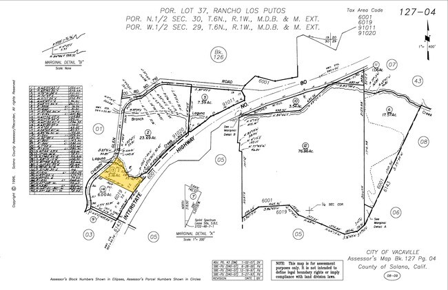
BK-BG 32-22 LOT 2
0127-040-130
Solano
Commercialnec
California
AE The base floodplain where base flood elevations are provided. AE Zones are now used on new format FIRMs instead of A1-A30 Zones.
2
2024
3.16 AC
2025
Vacaville
253101
North Bay/Santa Rosa
360 SF
NEARBY LISTINGS FOR SALE OR LEASE
DEMOGRAPHICS near 5930 Cherry Glen Rd
1 mile
3 mile
5 mile
2025 Total Population
895
50,306
146,357
2030 Population
892
50,645
147,929
Pop Growth 2025-2030
(0.34%)
+ 0.67%
+ 1.07%
Average Age
43
41
41
2025 Total Households
359
16,602
49,733
HH Growth 2025-2030
(0.28%)
+ 0.79%
+ 1.06%
Median Household Inc
$128,804
$96,574
$111,783
Avg Household Size
2.50
2.60
2.80
2025 Avg HH Vehicles
2.00
2.00
2.00
Median Home Value
$783,439
$690,453
$704,278
Median Year Built
1973
1977
1984
Nearby Places
Map Layers
Map Styles
 Street
 Aerial
Layers
 Traffic
 Biking
Places
Listings with unknown addresses are not visible on the map
- Restaurants
- Banks
- Shops
- Fitness
- Groceries
PUBLIC TRANSPORTATION
COMMUTER RAIL
Fairfield-Vacaville Amtrak Station (Capitol Corridor - Amtrak)
Drive
Walk
Distance
Fairfield-Vacaville Amtrak Station (Capitol Corridor - Amtrak)
13 min
7.4 mi
Suisun-Fairfield (Capitol Corridor - Capitol Corridor Joint Powers Authority)
Drive
Walk
Distance
Suisun-Fairfield (Capitol Corridor - Capitol Corridor Joint Powers Authority)
14 min
9.3 mi
Freight Ports
Port of Richmond
Drive
Walk
Distance
Port of Richmond
54 min
41.6 mi
Nearby Properties
Address
Land Use
TOTAL SIZE
Lot Size
Zoning
Address
Land Use
TOTAL SIZE
Lot Size
Zoning
67.79 AC
Address
Land Use
TOTAL SIZE
Lot Size
Zoning
12.64 AC
Address
Land Use
TOTAL SIZE
Lot Size
Zoning
159,056 SF
11.07 AC
Address
Land Use
TOTAL SIZE
Lot Size
Zoning
8.80 AC
Address
Land Use
TOTAL SIZE
Lot Size
Zoning
9.78 AC
Address
Land Use
TOTAL SIZE
Lot Size
Zoning
323,918 SF
7.18 AC
Address
Land Use
TOTAL SIZE
Lot Size
Zoning
7,302 SF
17.10 AC
Address
Land Use
TOTAL SIZE
Lot Size
Zoning
323,918 SF
7.72 AC
Address
Land Use
TOTAL SIZE
Lot Size
Zoning
123,136 SF
5.27 AC
Address
Land Use
TOTAL SIZE
Lot Size
Zoning
177,626 SF
10.04 AC
Address
Land Use
TOTAL SIZE
Lot Size
Zoning
38,696 SF
5.47 AC
Address
Land Use
TOTAL SIZE
Lot Size
Zoning
159,947 SF
10.98 AC
Address
Land Use
TOTAL SIZE
Lot Size
Zoning
100,079 SF
6.37 AC
RM2000PD
Address
Land Use
TOTAL SIZE
Lot Size
Zoning
112,080 SF
9.06 AC
Address
Land Use
TOTAL SIZE
Lot Size
Zoning
111,044 SF
6.11 AC
Address
Land Use
TOTAL SIZE
Lot Size
Zoning
50,456 SF
4.14 AC
Address
Land Use
TOTAL SIZE
Lot Size
Zoning
3.87 AC
Address
Land Use
TOTAL SIZE
Lot Size
Zoning
56,749 SF
3.66 AC
COMMERCIAL
Address
Land Use
TOTAL SIZE
Lot Size
Zoning
111,143 SF
10.84 AC
COM
Address
Land Use
TOTAL SIZE
Lot Size
Zoning
75,569 SF
4.82 AC
COMML
Address
Land Use
TOTAL SIZE
Lot Size
Zoning
78,268 SF
2.73 AC
COMML
Address
Land Use
TOTAL SIZE
Lot Size
Zoning
33,280 SF
8.64 AC
Address
Land Use
TOTAL SIZE
Lot Size
Zoning
109,004 SF
5.12 AC
Address
Land Use
TOTAL SIZE
Lot Size
Zoning
5.82 AC
Address
Land Use
TOTAL SIZE
Lot Size
Zoning
43,780 SF
4.02 AC
Address
Land Use
TOTAL SIZE
Lot Size
Zoning
43,264 SF
1.96 AC
Address
Land Use
TOTAL SIZE
Lot Size
Zoning
74,380 SF
3.14 AC
Address
Land Use
TOTAL SIZE
Lot Size
Zoning
123,136 SF
1.37 AC
Address
Land Use
TOTAL SIZE
Lot Size
Zoning
5.47 AC
Address
Land Use
TOTAL SIZE
Lot Size
Zoning
78,268 SF
5.33 AC
COMML
The World's #1 Commercial Real Estate Marketplace
Connect with us
© 2026 CoStar Group
The information above has been obtained from sources believed reliable. While we do not doubt its accuracy we have not verified it and make no guarantee, warranty or representation about it. It is your responsibility to independently confirm its accuracy and completeness. Any projections, opinions, assumptions, or estimates used are for example only and do not represent the current or future performance of the property. The value of this transaction to you depends on tax and other factors which should be evaluated by your tax, financial, and legal advisors. You and your advisors should conduct a careful, independent investigation of the property to determine to your satisfaction the suitability of the property for your needs.