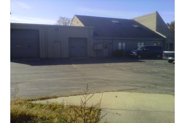
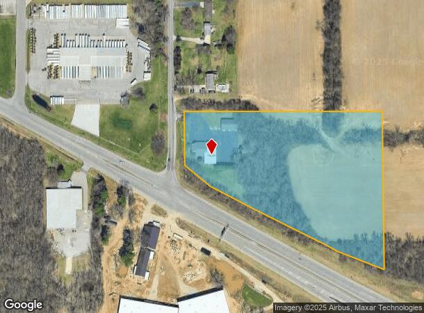
Property Record
53922 Olive Rd, South Bend, IN 46628
NEARBY LISTINGS FOR SALE OR LEASE
Property Detail
53922 Olive Rd
71-03-30-376-007.000-008
IRREG TRACT 8.736 AC +/- NE COR US 20 & OLIVE RD SE SW SEC 30 38 2E EX STRIP OFF W FRONTAGE FOR ROAD SPLIT 11/12 TO CITY WD #9302 12/22/10 13/14 CONS W/004-1020-034711 PER OWNERS REQ
Religious
St Joseph
X
Indiana
18141C0178D
44 SF
0
Greater South Bend
2024
South Bend/Mishawaka
011001
South Bend-Mishawaka, IN-MI
10,277 SF
DEMOGRAPHICS near 53922 Olive Rd
1 Mile
3 Mile
5 Mile
2024 Total Population
224
13,108
62,247
2029 Population
221
12,935
62,294
Pop Growth 2024-2029
(1.34%)
(1.32%)
+ 0.08%
Average Age
42
41
38
2024 Total Households
88
5,142
23,238
HH Growth 2024-2029
(2.27%)
(1.40%)
(0.11%)
Median Household Inc
$66,666
$56,051
$49,209
Avg Household Size
2.50
2.40
2.50
2024 Avg HH Vehicles
2.00
2.00
2.00
Median Home Value
$180,555
$152,059
$126,556
Median Year Built
1993
1964
1958
Nearby Places
Map Layers
Map Styles
 Street
 Aerial
- Restaurants
- Banks
- Shops
- Fitness
- Groceries
PUBLIC TRANSPORTATION
COMMUTER RAIL
South Bend Airport Station (South Shore Line - Northern Indiana Commuter Transportation District (South Shore Line))
DRIVE
WALK
Distance
South Bend Airport Station (South Shore Line - Northern Indiana Commuter Transportation District (South Shore Line))
6 min
3.0 mi
South Bend Amtrak Station (Capitol Limited - Amtrak, Lake Shore Limited - Amtrak)
DRIVE
WALK
Distance
South Bend Amtrak Station (Capitol Limited - Amtrak, Lake Shore Limited - Amtrak)
8 min
5.0 mi
AIRPORT
South Bend International
DRIVE
WALK
Distance
South Bend International
12 min
3.2 mi
Freight Ports
Port Milwaukee
DRIVE
WALK
Distance
Port Milwaukee
211 min
175.7 mi
Nearby Properties
Address
Land Use
TOTAL SIZE
Lot Size
Zoning
Address
Land Use
TOTAL SIZE
Lot Size
Zoning
252,327 SF
131 SF
Address
Land Use
TOTAL SIZE
Lot Size
Zoning
232,200 SF
87 SF
Address
Land Use
TOTAL SIZE
Lot Size
Zoning
633,966 SF
87 SF
Address
Land Use
TOTAL SIZE
Lot Size
Zoning
213,400 SF
44 SF
Address
Land Use
TOTAL SIZE
Lot Size
Zoning
343,964 SF
131 SF
Address
Land Use
TOTAL SIZE
Lot Size
Zoning
225,000 SF
19.59 AC
Address
Land Use
TOTAL SIZE
Lot Size
Zoning
210,420 SF
131 SF
Address
Land Use
TOTAL SIZE
Lot Size
Zoning
212,497 SF
131 SF
Address
Land Use
TOTAL SIZE
Lot Size
Zoning
210,420 SF
131 SF
Address
Land Use
TOTAL SIZE
Lot Size
Zoning
111,803 SF
7.45 AC
Address
Land Use
TOTAL SIZE
Lot Size
Zoning
72,418 SF
131 SF
Address
Land Use
TOTAL SIZE
Lot Size
Zoning
79,451 SF
87 SF
Address
Land Use
TOTAL SIZE
Lot Size
Zoning
4,428 SF
0.02 AC
Address
Land Use
TOTAL SIZE
Lot Size
Zoning
204,880 SF
44 SF
Address
Land Use
TOTAL SIZE
Lot Size
Zoning
255,684 SF
23.71 AC
Address
Land Use
TOTAL SIZE
Lot Size
Zoning
165,000 SF
87 SF
Address
Land Use
TOTAL SIZE
Lot Size
Zoning
397,100 SF
45.61 AC
Address
Land Use
TOTAL SIZE
Lot Size
Zoning
92,456 SF
44 SF
Address
Land Use
TOTAL SIZE
Lot Size
Zoning
84,398 SF
44 SF
Address
Land Use
TOTAL SIZE
Lot Size
Zoning
143,917 SF
87 SF
Address
Land Use
TOTAL SIZE
Lot Size
Zoning
85,928 SF
7.83 AC
Address
Land Use
TOTAL SIZE
Lot Size
Zoning
266,881 SF
26.20 AC
Address
Land Use
TOTAL SIZE
Lot Size
Zoning
164,850 SF
44 SF
Address
Land Use
TOTAL SIZE
Lot Size
Zoning
499,104 SF
87 SF
Address
Land Use
TOTAL SIZE
Lot Size
Zoning
194,712 SF
14.81 AC
Address
Land Use
TOTAL SIZE
Lot Size
Zoning
211,200 SF
44 SF
Address
Land Use
TOTAL SIZE
Lot Size
Zoning
143,890 SF
87 SF
Address
Land Use
TOTAL SIZE
Lot Size
Zoning
58,827 SF
131 SF
Address
Land Use
TOTAL SIZE
Lot Size
Zoning
143,805 SF
8.44 AC
Address
Land Use
TOTAL SIZE
Lot Size
Zoning
152,807 SF
87 SF
The World's #1 Commercial Real Estate Marketplace
Connect with us
© 2025 CoStar Group
The information above has been obtained from sources believed reliable. While we do not doubt its accuracy we have not verified it and make no guarantee, warranty or representation about it. It is your responsibility to independently confirm its accuracy and completeness. Any projections, opinions, assumptions, or estimates used are for example only and do not represent the current or future performance of the property. The value of this transaction to you depends on tax and other factors which should be evaluated by your tax, financial, and legal advisors. You and your advisors should conduct a careful, independent investigation of the property to determine to your satisfaction the suitability of the property for your needs.