Property Record
5127 Sw Wanamaker Rd, Topeka, KS 66610
NEARBY LISTINGS FOR SALE OR LEASE
Property Detail
5127 Sw Wanamaker Rd
Topeka, KS
Afc Subdivision
149-29-0-40-01-013-000
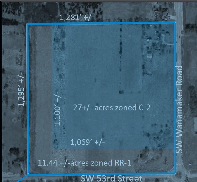
AFC SUBDIVISION, S29, T12, R15, BLOCK A, LOT 1 +, ACRES 37.28, BLK A LOTS 1-2, AFC SUB
Agriculturalland
Shawnee
X
Kansas
20177C0282E
1
2024
11.85 AC
2025
Topeka
003605
Kansas City
6,498 SF
DEMOGRAPHICS near 5127 Sw Wanamaker Rd
1 Mile
3 Mile
5 Mile
2024 Total Population
1,190
17,692
63,141
2029 Population
1,186
17,329
62,189
Pop Growth 2024-2029
(0.34%)
(2.05%)
(1.51%)
Average Age
43
44
41
2024 Total Households
407
7,310
26,907
HH Growth 2024-2029
(0.25%)
(2.23%)
(1.57%)
Median Household Inc
$112,065
$87,003
$63,772
Avg Household Size
2.80
2.40
2.30
2024 Avg HH Vehicles
2.00
2.00
2.00
Median Home Value
$333,536
$230,943
$165,977
Median Year Built
2002
1987
1976
Nearby Places
Map Layers
Map Styles
 Street
 Aerial
- Restaurants
- Banks
- Shops
- Fitness
- Groceries
SALE & LEASE HISTORY
LISTING DATE
SALE/LEASE

Sep 24, 2016
For Sale
Nearby Properties
Address
Land Use
TOTAL SIZE
Lot Size
Zoning
Address
Land Use
TOTAL SIZE
Lot Size
Zoning
189,886 SF
37.38 AC
RR1
Address
Land Use
TOTAL SIZE
Lot Size
Zoning
88,935 SF
20.24 AC
C4
Address
Land Use
TOTAL SIZE
Lot Size
Zoning
176,935 SF
37.83 AC
RR1
Address
Land Use
TOTAL SIZE
Lot Size
Zoning
71,575 SF
10.93 AC
C2,C4
Address
Land Use
TOTAL SIZE
Lot Size
Zoning
19.37 AC
Address
Land Use
TOTAL SIZE
Lot Size
Zoning
72,482 SF
19.53 AC
R1
Address
Land Use
TOTAL SIZE
Lot Size
Zoning
74,659 SF
15.24 AC
RR1
Address
Land Use
TOTAL SIZE
Lot Size
Zoning
36,511 SF
7.05 AC
R1
Address
Land Use
TOTAL SIZE
Lot Size
Zoning
11,460 SF
5.03 AC
R1
Address
Land Use
TOTAL SIZE
Lot Size
Zoning
23,026 SF
8.62 AC
R1,RR1
Address
Land Use
TOTAL SIZE
Lot Size
Zoning
78,287 SF
6.41 AC
C4
Address
Land Use
TOTAL SIZE
Lot Size
Zoning
87.23 AC
R1
Address
Land Use
TOTAL SIZE
Lot Size
Zoning
77,954 SF
10.84 AC
C4
Address
Land Use
TOTAL SIZE
Lot Size
Zoning
122,186 SF
12.73 AC
PUD,M2
Address
Land Use
TOTAL SIZE
Lot Size
Zoning
19,216 SF
6.89 AC
RR1
Address
Land Use
TOTAL SIZE
Lot Size
Zoning
10.46 AC
M2,OI2,RR1
Address
Land Use
TOTAL SIZE
Lot Size
Zoning
15,082 SF
2.67 AC
C4
Address
Land Use
TOTAL SIZE
Lot Size
Zoning
74,808 SF
8.80 AC
PUD,C2
Address
Land Use
TOTAL SIZE
Lot Size
Zoning
38,035 SF
6.38 AC
PUD,R1
Address
Land Use
TOTAL SIZE
Lot Size
Zoning
62,230 SF
7 AC
PUD,C4
Address
Land Use
TOTAL SIZE
Lot Size
Zoning
17,098 SF
15.98 AC
R1
Address
Land Use
TOTAL SIZE
Lot Size
Zoning
21,246 SF
3.05 AC
PUD,OI2,C2
Address
Land Use
TOTAL SIZE
Lot Size
Zoning
34,404 SF
6.39 AC
C4
Address
Land Use
TOTAL SIZE
Lot Size
Zoning
0.74 AC
RR1
Address
Land Use
TOTAL SIZE
Lot Size
Zoning
99,902 SF
4.13 AC
PUD,M2
Address
Land Use
TOTAL SIZE
Lot Size
Zoning
8,741 SF
1.28 AC
C2
Address
Land Use
TOTAL SIZE
Lot Size
Zoning
1,680 SF
112.95 AC
RR1
Address
Land Use
TOTAL SIZE
Lot Size
Zoning
44,462 SF
4.56 AC
C4
Address
Land Use
TOTAL SIZE
Lot Size
Zoning
8,000 SF
5.30 AC
RR1
Address
Land Use
TOTAL SIZE
Lot Size
Zoning
44,653 SF
4.86 AC
PUD,M2
The World's #1 Commercial Real Estate Marketplace
Connect with us
© 2025 CoStar Group
The information above has been obtained from sources believed reliable. While we do not doubt its accuracy we have not verified it and make no guarantee, warranty or representation about it. It is your responsibility to independently confirm its accuracy and completeness. Any projections, opinions, assumptions, or estimates used are for example only and do not represent the current or future performance of the property. The value of this transaction to you depends on tax and other factors which should be evaluated by your tax, financial, and legal advisors. You and your advisors should conduct a careful, independent investigation of the property to determine to your satisfaction the suitability of the property for your needs.