Property Record
54 Hampton House Rd, Newton, NJ 07860
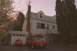

Property Detail
54 Hampton House Rd
10-03603-0000-00013
INCL BLK 3603 P/O LOT 13 UNIT C3 35
Commercialnec
Sussex
HCMF
New Jersey
B and X Area of moderate flood hazard, usually the area between the limits of the 100-year and 500-year floods.
13
2024
1.71 AC
2025
Sussex County
372100
Northern New Jersey
759 SF
Newark, NJ
NEARBY LISTINGS FOR SALE OR LEASE
-
-
View all Newton listings for sale on LoopNet.com
DEMOGRAPHICS near 54 Hampton House Rd
1 mile
3 mile
5 mile
2025 Total Population
1,062
13,964
25,741
2030 Population
1,078
14,173
26,138
Pop Growth 2025-2030
+ 1.51%
+ 1.50%
+ 1.54%
Average Age
48
43
43
2025 Total Households
505
5,749
10,044
HH Growth 2025-2030
+ 1.39%
+ 1.98%
+ 1.66%
Median Household Inc
$94,096
$86,961
$105,659
Avg Household Size
2.10
2.30
2.50
2025 Avg HH Vehicles
2.00
2.00
2.00
Median Home Value
$258,542
$333,393
$392,691
Median Year Built
1982
1970
1973
Nearby Places
Map Layers
Map Styles
 Street
 Aerial
Layers
 Traffic
 Biking
Places
Listings with unknown addresses are not visible on the map
- Restaurants
- Banks
- Shops
- Fitness
- Groceries
Nearby Properties
Address
Land Use
TOTAL SIZE
Lot Size
Zoning
Address
Land Use
TOTAL SIZE
Lot Size
Zoning
20 AC
SD-1
Address
Land Use
TOTAL SIZE
Lot Size
Zoning
49.29 AC
SD-7
Address
Land Use
TOTAL SIZE
Lot Size
Zoning
6.10 AC
T-5+
Address
Land Use
TOTAL SIZE
Lot Size
Zoning
4.56 AC
T-4
Address
Land Use
TOTAL SIZE
Lot Size
Zoning
88.63 AC
SD-2
Address
Land Use
TOTAL SIZE
Lot Size
Zoning
96.14 AC
R-2
Address
Land Use
TOTAL SIZE
Lot Size
Zoning
20.50 AC
SD-6
Address
Land Use
TOTAL SIZE
Lot Size
Zoning
47,400 SF
71 AC
SD-4
Address
Land Use
TOTAL SIZE
Lot Size
Zoning
800 SF
13.50 AC
T-3
Address
Land Use
TOTAL SIZE
Lot Size
Zoning
11.96 AC
SD-3
Address
Land Use
TOTAL SIZE
Lot Size
Zoning
7.21 AC
T-5
Address
Land Use
TOTAL SIZE
Lot Size
Zoning
12,504 SF
3.14 AC
SD-3
Address
Land Use
TOTAL SIZE
Lot Size
Zoning
Address
Land Use
TOTAL SIZE
Lot Size
Zoning
17.79 AC
SD-3
Address
Land Use
TOTAL SIZE
Lot Size
Zoning
2.09 AC
T-5
Address
Land Use
TOTAL SIZE
Lot Size
Zoning
20.62 AC
HCMF
Address
Land Use
TOTAL SIZE
Lot Size
Zoning
52.16 AC
HCMF
Address
Land Use
TOTAL SIZE
Lot Size
Zoning
72,992 SF
4.75 AC
SD-3
Address
Land Use
TOTAL SIZE
Lot Size
Zoning
5.20 AC
T-3
Address
Land Use
TOTAL SIZE
Lot Size
Zoning
50,814 SF
8.62 AC
SD-3
Address
Land Use
TOTAL SIZE
Lot Size
Zoning
26,611 SF
1.21 AC
T-5+
Address
Land Use
TOTAL SIZE
Lot Size
Zoning
45,532 SF
10.31 AC
R1
Address
Land Use
TOTAL SIZE
Lot Size
Zoning
68,221 SF
7.89 AC
SD-1
Address
Land Use
TOTAL SIZE
Lot Size
Zoning
1,140 SF
1.45 AC
SD-6
Address
Land Use
TOTAL SIZE
Lot Size
Zoning
8.90 AC
HCMF
Address
Land Use
TOTAL SIZE
Lot Size
Zoning
11 AC
SD-6
Address
Land Use
TOTAL SIZE
Lot Size
Zoning
0.56 AC
T-5
Address
Land Use
TOTAL SIZE
Lot Size
Zoning
2,982 SF
5.41 AC
SD-3
Address
Land Use
TOTAL SIZE
Lot Size
Zoning
2.24 AC
T-5
Address
Land Use
TOTAL SIZE
Lot Size
Zoning
2.49 AC
SD-3
The World's #1 Commercial Real Estate Marketplace
Connect with us
© 2026 CoStar Group
The information above has been obtained from sources believed reliable. While we do not doubt its accuracy we have not verified it and make no guarantee, warranty or representation about it. It is your responsibility to independently confirm its accuracy and completeness. Any projections, opinions, assumptions, or estimates used are for example only and do not represent the current or future performance of the property. The value of this transaction to you depends on tax and other factors which should be evaluated by your tax, financial, and legal advisors. You and your advisors should conduct a careful, independent investigation of the property to determine to your satisfaction the suitability of the property for your needs.