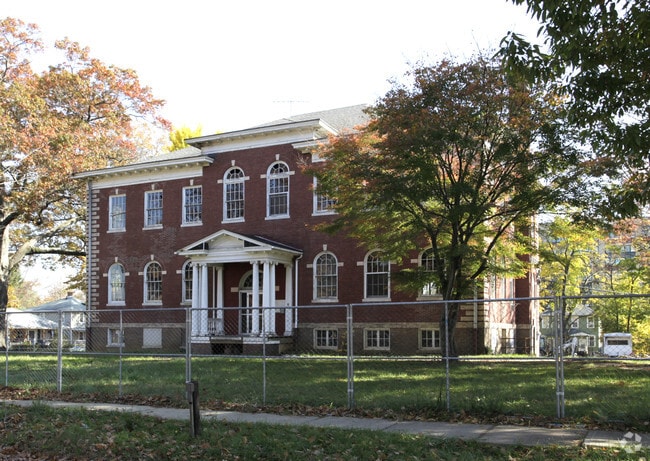
Property Record
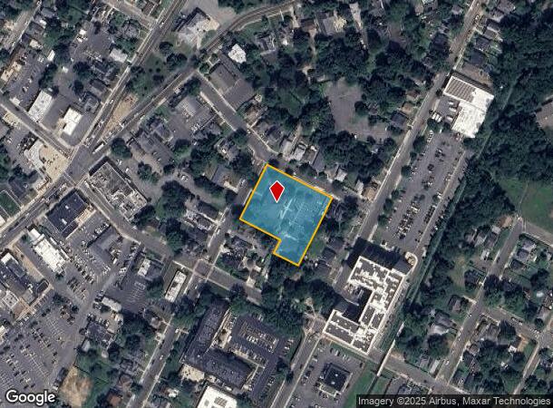
54 Hudson St, Freehold, NJ 07728
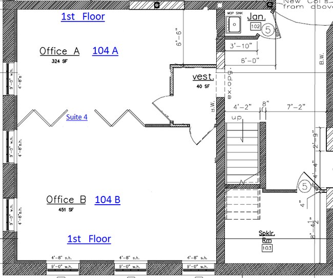
Current Lease Availabilities
NEARBY LISTINGS FOR SALE OR LEASE
Property Detail
54 Hudson St
16-00052-0000-00004
POLICE HDQTRS
Officebuilding
Monmouth
X
New Jersey
34025C0144F
4
2024
1.21 AC
2025
Western Monmouth
810800
Northern New Jersey
11,970 SF
New York-Jersey City-White Plains, NY-NJ
DEMOGRAPHICS near 54 Hudson St
1 Mile
3 Mile
5 Mile
2024 Total Population
14,099
46,220
96,863
2029 Population
13,901
45,588
95,508
Pop Growth 2024-2029
(1.40%)
(1.37%)
(1.40%)
Average Age
38
41
42
2024 Total Households
4,651
15,887
33,617
HH Growth 2024-2029
(1.66%)
(1.62%)
(1.60%)
Median Household Inc
$77,326
$121,186
$133,428
Avg Household Size
2.90
2.80
2.80
2024 Avg HH Vehicles
2.00
2.00
2.00
Median Home Value
$382,106
$498,378
$546,626
Median Year Built
1970
1979
1982
Nearby Places
- Restaurants
- Banks
- Shops
- Fitness
- Groceries
PUBLIC TRANSPORTATION
AIRPORT
Trenton Mercer
DRIVE
WALK
Distance
Trenton Mercer
54 min
35.5 mi
Freight Ports
New York Container Terminal
DRIVE
WALK
Distance
New York Container Terminal
45 min
33.3 mi
Nearby Properties
Address
Land Use
TOTAL SIZE
Lot Size
Zoning
Address
Land Use
TOTAL SIZE
Lot Size
Zoning
825,686 SF
151.47 AC
575
Address
Land Use
TOTAL SIZE
Lot Size
Zoning
52.16 AC
H-1
Address
Land Use
TOTAL SIZE
Lot Size
Zoning
4,649 SF
40.27 AC
ML-7
Address
Land Use
TOTAL SIZE
Lot Size
Zoning
56.99 AC
C1
Address
Land Use
TOTAL SIZE
Lot Size
Zoning
904,310 SF
85.13 AC
M2M1
Address
Land Use
TOTAL SIZE
Lot Size
Zoning
285,037 SF
40.82 AC
H-1
Address
Land Use
TOTAL SIZE
Lot Size
Zoning
15.69 AC
HMUD
Address
Land Use
TOTAL SIZE
Lot Size
Zoning
267,666 SF
29.06 AC
M-1
Address
Land Use
TOTAL SIZE
Lot Size
Zoning
73,884 SF
37.60 AC
R-40
Address
Land Use
TOTAL SIZE
Lot Size
Zoning
114,738 SF
19.02 AC
M-1
Address
Land Use
TOTAL SIZE
Lot Size
Zoning
241,399 SF
69.89 AC
R-40
Address
Land Use
TOTAL SIZE
Lot Size
Zoning
42,982 SF
118.30 AC
R-40
Address
Land Use
TOTAL SIZE
Lot Size
Zoning
2.91 AC
RCR
Address
Land Use
TOTAL SIZE
Lot Size
Zoning
278,199 SF
6.92 AC
R-10
Address
Land Use
TOTAL SIZE
Lot Size
Zoning
81,690 SF
42.46 AC
RMZ-
Address
Land Use
TOTAL SIZE
Lot Size
Zoning
13,730 SF
19.29 AC
CM-3
Address
Land Use
TOTAL SIZE
Lot Size
Zoning
19.02 AC
HD
Address
Land Use
TOTAL SIZE
Lot Size
Zoning
176,661 SF
13.04 AC
OB01
Address
Land Use
TOTAL SIZE
Lot Size
Zoning
138.38 AC
R-E
Address
Land Use
TOTAL SIZE
Lot Size
Zoning
82,872 SF
25.58 AC
B-10
Address
Land Use
TOTAL SIZE
Lot Size
Zoning
21 AC
R-40
Address
Land Use
TOTAL SIZE
Lot Size
Zoning
23,260 SF
17.90 AC
B-10
Address
Land Use
TOTAL SIZE
Lot Size
Zoning
48,451 SF
12.17 AC
B-10
Address
Land Use
TOTAL SIZE
Lot Size
Zoning
200,294 SF
12 AC
R10
Address
Land Use
TOTAL SIZE
Lot Size
Zoning
93.79 AC
R-60
Address
Land Use
TOTAL SIZE
Lot Size
Zoning
7,112 SF
10.01 AC
CM3A
Address
Land Use
TOTAL SIZE
Lot Size
Zoning
13.21 AC
OB01
Address
Land Use
TOTAL SIZE
Lot Size
Zoning
185,237 SF
20.18 AC
VC
Address
Land Use
TOTAL SIZE
Lot Size
Zoning
54,065 SF
19.07 AC
CM3A
Address
Land Use
TOTAL SIZE
Lot Size
Zoning
1,800 SF
83.93 AC
R120
The World's #1 Commercial Real Estate Marketplace
Connect with us
© 2025 CoStar Group
The information above has been obtained from sources believed reliable. While we do not doubt its accuracy we have not verified it and make no guarantee, warranty or representation about it. It is your responsibility to independently confirm its accuracy and completeness. Any projections, opinions, assumptions, or estimates used are for example only and do not represent the current or future performance of the property. The value of this transaction to you depends on tax and other factors which should be evaluated by your tax, financial, and legal advisors. You and your advisors should conduct a careful, independent investigation of the property to determine to your satisfaction the suitability of the property for your needs.