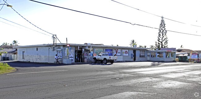
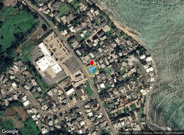
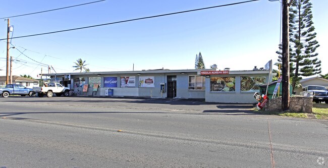
Property Record
54 Kamehameha Hwy, Hauula, HI 96717
NEARBY LISTINGS FOR SALE OR LEASE
-
-
View all Hauula listings for sale on LoopNet.com
Property Detail
54 Kamehameha Hwy
1-5-4-012-004-0000
LOT137-A 13,031 SF MAP 23 LCCONS 23 TOG/E PAR D (171 SF) & PAR E (158 SF) DES
Commercialnec
Honolulu
X
Hawaii
15003C0135F
137-a
2024
0.32 AC
2025
Windward
010202
Hawaii
10,008 SF
Urban Honolulu, HI
DEMOGRAPHICS near 54 Kamehameha Hwy
1 Mile
3 Mile
5 Mile
2024 Total Population
1,796
9,554
12,204
2029 Population
1,699
8,991
11,471
Pop Growth 2024-2029
(5.40%)
(5.89%)
(6.01%)
Average Age
35
34
34
2024 Total Households
420
1,842
2,426
HH Growth 2024-2029
(6.67%)
(7.87%)
(7.83%)
Median Household Inc
$90,104
$100,872
$97,613
Avg Household Size
3.70
3.70
3.70
2024 Avg HH Vehicles
2.00
2.00
2.00
Median Home Value
$889,072
$915,029
$852,046
Median Year Built
1972
1974
1975
Nearby Places
Map Layers
Map Styles
 Street
 Aerial
- Restaurants
- Banks
- Shops
- Fitness
- Groceries
PUBLIC TRANSPORTATION
AIRPORT
Daniel K Inouye International
DRIVE
WALK
Distance
Daniel K Inouye International
64 min
30.8 mi
Nearby Properties
Address
Land Use
TOTAL SIZE
Lot Size
Zoning
Address
Land Use
TOTAL SIZE
Lot Size
Zoning
6,186 SF
204.06 AC
AG-1
Address
Land Use
TOTAL SIZE
Lot Size
Zoning
134,413 SF
18.09 AC
B-2
Address
Land Use
TOTAL SIZE
Lot Size
Zoning
35,148 SF
5.91 AC
Resort
Address
Land Use
TOTAL SIZE
Lot Size
Zoning
31,734 SF
23.76 AC
B-2
Address
Land Use
TOTAL SIZE
Lot Size
Zoning
1,373.40 AC
P-1
Address
Land Use
TOTAL SIZE
Lot Size
Zoning
53,297 SF
6.14 AC
B-1
Address
Land Use
TOTAL SIZE
Lot Size
Zoning
70,773 SF
3.64 AC
B-1
Address
Land Use
TOTAL SIZE
Lot Size
Zoning
506 SF
84.16 AC
AG-2
Address
Land Use
TOTAL SIZE
Lot Size
Zoning
6,883 SF
7.83 AC
AG-2
Address
Land Use
TOTAL SIZE
Lot Size
Zoning
2,539.08 AC
P-1
Address
Land Use
TOTAL SIZE
Lot Size
Zoning
9,226 SF
0.47 AC
B-1
Address
Land Use
TOTAL SIZE
Lot Size
Zoning
73.71 AC
P-2
Address
Land Use
TOTAL SIZE
Lot Size
Zoning
2,206.84 AC
AG-2
Address
Land Use
TOTAL SIZE
Lot Size
Zoning
2,039.90 AC
P-1
Address
Land Use
TOTAL SIZE
Lot Size
Zoning
84.70 AC
AG-2
Address
Land Use
TOTAL SIZE
Lot Size
Zoning
4,462 SF
0.69 AC
B-2
Address
Land Use
TOTAL SIZE
Lot Size
Zoning
2.55 AC
AG-2
Address
Land Use
TOTAL SIZE
Lot Size
Zoning
7,100 SF
5.40 AC
AG-2
Address
Land Use
TOTAL SIZE
Lot Size
Zoning
5,120 SF
0.67 AC
R-5
Address
Land Use
TOTAL SIZE
Lot Size
Zoning
7,311 SF
2.17 AC
A/52/50
Address
Land Use
TOTAL SIZE
Lot Size
Zoning
8,000 SF
0.27 AC
B-1
Address
Land Use
TOTAL SIZE
Lot Size
Zoning
130.95 AC
P-1
Address
Land Use
TOTAL SIZE
Lot Size
Zoning
8.19 AC
AG-2
Address
Land Use
TOTAL SIZE
Lot Size
Zoning
7,524 SF
1.32 AC
AG-1
Address
Land Use
TOTAL SIZE
Lot Size
Zoning
20.75 AC
AG-1
Address
Land Use
TOTAL SIZE
Lot Size
Zoning
6,725 SF
1.59 AC
B-1
Address
Land Use
TOTAL SIZE
Lot Size
Zoning
15,560 SF
0.81 AC
B-1
Address
Land Use
TOTAL SIZE
Lot Size
Zoning
3.07 AC
B-2
Address
Land Use
TOTAL SIZE
Lot Size
Zoning
2,106 SF
8.77 AC
AG-2
Address
Land Use
TOTAL SIZE
Lot Size
Zoning
1,856 SF
13.20 AC
AG-1
The World's #1 Commercial Real Estate Marketplace
Connect with us
© 2025 CoStar Group
The information above has been obtained from sources believed reliable. While we do not doubt its accuracy we have not verified it and make no guarantee, warranty or representation about it. It is your responsibility to independently confirm its accuracy and completeness. Any projections, opinions, assumptions, or estimates used are for example only and do not represent the current or future performance of the property. The value of this transaction to you depends on tax and other factors which should be evaluated by your tax, financial, and legal advisors. You and your advisors should conduct a careful, independent investigation of the property to determine to your satisfaction the suitability of the property for your needs.