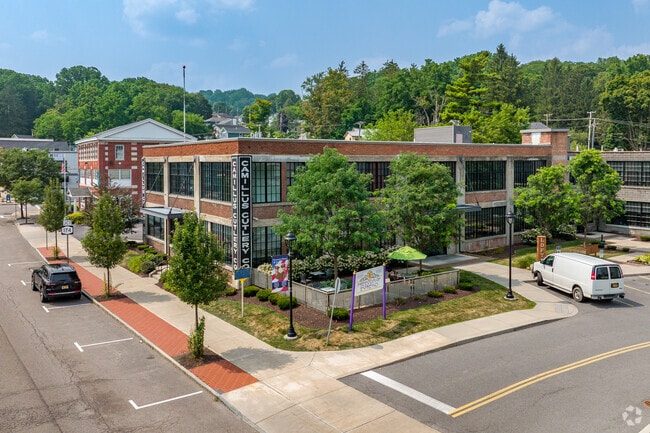
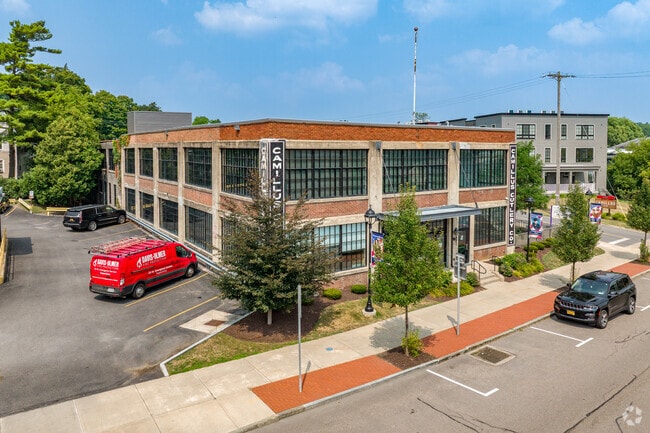
Property Record
54 Main St, Camillus, NY 13031

Property Detail
54 Main St
312001-002-000-0001-004-001-0000
Onondaga
Apartment
New York
05 - COMME
4.001
AE The base floodplain where base flood elevations are provided. AE Zones are now used on new format FIRMs instead of A1-A30 Zones.
2.49 AC
2025
Outer NW Onondaga County
2025
Syracuse
012200
Syracuse, NY
45,800 SF
NEARBY LISTINGS FOR SALE OR LEASE
-
-
View all Camillus listings for sale on LoopNet.com
DEMOGRAPHICS near 54 Main St
1 mile
3 mile
5 mile
2025 Total Population
3,349
17,925
45,361
2030 Population
3,328
17,759
44,933
Pop Growth 2025-2030
(0.63%)
(0.93%)
(0.94%)
Average Age
43
44
43
2025 Total Households
1,457
7,656
18,853
HH Growth 2025-2030
(0.55%)
(1.02%)
(1.01%)
Median Household Inc
$89,831
$96,162
$91,162
Avg Household Size
2.20
2.30
2.30
2025 Avg HH Vehicles
2.00
2.00
2.00
Median Home Value
$227,309
$229,237
$213,207
Median Year Built
1964
1966
1962
Nearby Places
Map Layers
Map Styles
 Street
 Aerial
Layers
 Traffic
 Biking
Places
Listings with unknown addresses are not visible on the map
- Restaurants
- Banks
- Shops
- Fitness
- Groceries
PUBLIC TRANSPORTATION
AIRPORT
Syracuse Hancock International
Drive
Walk
Distance
Syracuse Hancock International
23 min
15.4 mi
Nearby Properties
Address
Land Use
TOTAL SIZE
Lot Size
Zoning
Address
Land Use
TOTAL SIZE
Lot Size
Zoning
256,000 SF
44.31 AC
08 - GOVER
Address
Land Use
TOTAL SIZE
Lot Size
Zoning
6,106 SF
32.71 AC
06
Address
Land Use
TOTAL SIZE
Lot Size
Zoning
22,692 SF
28.07 AC
03 - MULTI
Address
Land Use
TOTAL SIZE
Lot Size
Zoning
109,800 SF
111.52 AC
08 - GOVER
Address
Land Use
TOTAL SIZE
Lot Size
Zoning
10,200 SF
5.96 AC
03 - MULTI
Address
Land Use
TOTAL SIZE
Lot Size
Zoning
205,018 SF
18.15 AC
05 - COMME
Address
Land Use
TOTAL SIZE
Lot Size
Zoning
3,136 SF
16.30 AC
03 - MULTI
Address
Land Use
TOTAL SIZE
Lot Size
Zoning
121,941 SF
30.34 AC
08 - GOVER
Address
Land Use
TOTAL SIZE
Lot Size
Zoning
104,592 SF
20.41 AC
08 - GOVER
Address
Land Use
TOTAL SIZE
Lot Size
Zoning
55,243 SF
9.25 AC
05 - COMME
Address
Land Use
TOTAL SIZE
Lot Size
Zoning
12,325 SF
16.12 AC
07 - MIXED
Address
Land Use
TOTAL SIZE
Lot Size
Zoning
157,675 SF
12.88 AC
Address
Land Use
TOTAL SIZE
Lot Size
Zoning
254,436 SF
21.94 AC
06 - INDUS
Address
Land Use
TOTAL SIZE
Lot Size
Zoning
138,735 SF
13.81 AC
05 - COMME
Address
Land Use
TOTAL SIZE
Lot Size
Zoning
78,545 SF
8.55 AC
05 - COMME
Address
Land Use
TOTAL SIZE
Lot Size
Zoning
13,032 SF
7.63 AC
Address
Land Use
TOTAL SIZE
Lot Size
Zoning
114,396 SF
9.98 AC
05 - COMME
Address
Land Use
TOTAL SIZE
Lot Size
Zoning
118,035 SF
26.43 AC
07 - MIXED
Address
Land Use
TOTAL SIZE
Lot Size
Zoning
72,768 SF
2.70 AC
6
Address
Land Use
TOTAL SIZE
Lot Size
Zoning
3.79 AC
02 - SINGL
Address
Land Use
TOTAL SIZE
Lot Size
Zoning
43,664 SF
1.87 AC
Address
Land Use
TOTAL SIZE
Lot Size
Zoning
44,511 SF
1.97 AC
05 - COMME
Address
Land Use
TOTAL SIZE
Lot Size
Zoning
2,580 SF
48.74 AC
06 - INDUS
Address
Land Use
TOTAL SIZE
Lot Size
Zoning
7,853 SF
28.03 AC
6
Address
Land Use
TOTAL SIZE
Lot Size
Zoning
3,721 SF
12.95 AC
02 - SINGL
Address
Land Use
TOTAL SIZE
Lot Size
Zoning
4.38 AC
02 - SINGL
Address
Land Use
TOTAL SIZE
Lot Size
Zoning
51,222 SF
4.28 AC
05 - COMME
Address
Land Use
TOTAL SIZE
Lot Size
Zoning
13,284 SF
6.59 AC
02 - SINGL
Address
Land Use
TOTAL SIZE
Lot Size
Zoning
9,280 SF
12.45 AC
03 - MULTI
Address
Land Use
TOTAL SIZE
Lot Size
Zoning
69.49 AC
02
The World's #1 Commercial Real Estate Marketplace
Connect with us
© 2026 CoStar Group
The information above has been obtained from sources believed reliable. While we do not doubt its accuracy we have not verified it and make no guarantee, warranty or representation about it. It is your responsibility to independently confirm its accuracy and completeness. Any projections, opinions, assumptions, or estimates used are for example only and do not represent the current or future performance of the property. The value of this transaction to you depends on tax and other factors which should be evaluated by your tax, financial, and legal advisors. You and your advisors should conduct a careful, independent investigation of the property to determine to your satisfaction the suitability of the property for your needs.