Property Record
54 N Dixie Hwy, Stuart, FL 34994


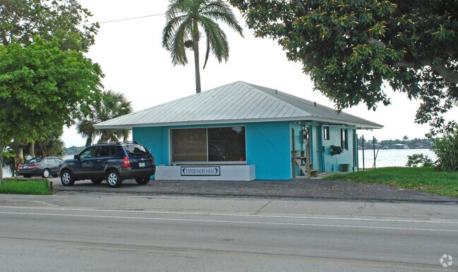
Property Detail
54 N Dixie Hwy
05-38-41-000-000-00040-5
THAT PART OF GOV LOT 3 IN 5-38-41 LYING WEST OF US HWY1 (LESS THAT PORTION THEREOF CONVEYED TO THE STATE OF FL IN OR BK 102 PG 90) TOGETHER WITH GRANTORS RIGHT TITLE AND INTEREST IN A PARCEL OF SUBMERGED LAND IN THE ST LUCIE RIVER IN 5-38-41 DESCRIBE
Commercialacreage
Martin
B1
Florida
AE The base floodplain where base flood elevations are provided. AE Zones are now used on new format FIRMs instead of A1-A30 Zones.
3
2024
6.80 AC
2025
Port St Lucie
000300
Port St Lucie/Fort Pierce
1,842 SF
Port St. Lucie, FL
NEARBY LISTINGS FOR SALE OR LEASE
DEMOGRAPHICS near 54 N Dixie Hwy
1 mile
3 mile
5 mile
2025 Total Population
3,321
47,405
107,217
2030 Population
3,425
49,701
113,906
Pop Growth 2025-2030
+ 3.13%
+ 4.84%
+ 6.24%
Average Age
50
49
48
2025 Total Households
1,610
21,552
47,184
HH Growth 2025-2030
+ 2.86%
+ 4.77%
+ 6.22%
Median Household Inc
$93,281
$72,546
$76,866
Avg Household Size
2.00
2.10
2.20
2025 Avg HH Vehicles
2.00
2.00
2.00
Median Home Value
$642,706
$435,636
$440,428
Median Year Built
1981
1984
1986
Nearby Places
Map Layers
Map Styles
 Street
 Aerial
Transit
 Traffic
 Biking
Places
Listings with unknown addresses are not visible on the map
- Restaurants
- Banks
- Shops
- Fitness
- Groceries
SALE & LEASE HISTORY
LISTING DATE
SALE/LEASE

Nov 01, 2016
For Lease
Nearby Properties
Address
Land Use
TOTAL SIZE
Lot Size
Zoning
Address
Land Use
TOTAL SIZE
Lot Size
Zoning
609,195 SF
13.77 AC
H
Address
Land Use
TOTAL SIZE
Lot Size
Zoning
436,532 SF
636.83 AC
PAF
Address
Land Use
TOTAL SIZE
Lot Size
Zoning
481,508 SF
59.41 AC
PUDC
Address
Land Use
TOTAL SIZE
Lot Size
Zoning
11.34 AC
Address
Land Use
TOTAL SIZE
Lot Size
Zoning
292,279 SF
65.79 AC
R2
Address
Land Use
TOTAL SIZE
Lot Size
Zoning
309,031 SF
76.74 AC
RPUD
Address
Land Use
TOTAL SIZE
Lot Size
Zoning
378,814 SF
34.25 AC
PUDR
Address
Land Use
TOTAL SIZE
Lot Size
Zoning
14.86 AC
M1
Address
Land Use
TOTAL SIZE
Lot Size
Zoning
310,460 SF
48.85 AC
PS2
Address
Land Use
TOTAL SIZE
Lot Size
Zoning
6.66 AC
RPUD
Address
Land Use
TOTAL SIZE
Lot Size
Zoning
23.08 AC
RM8
Address
Land Use
TOTAL SIZE
Lot Size
Zoning
9.45 AC
RS6
Address
Land Use
TOTAL SIZE
Lot Size
Zoning
160,211 SF
17.44 AC
CPUD
Address
Land Use
TOTAL SIZE
Lot Size
Zoning
284,610 SF
33.04 AC
R3
Address
Land Use
TOTAL SIZE
Lot Size
Zoning
195,729 SF
20.25 AC
CPUD
Address
Land Use
TOTAL SIZE
Lot Size
Zoning
545,151 SF
62.49 AC
PAF
Address
Land Use
TOTAL SIZE
Lot Size
Zoning
127,238 SF
3.62 AC
P
Address
Land Use
TOTAL SIZE
Lot Size
Zoning
189,035 SF
20.63 AC
R3
Address
Land Use
TOTAL SIZE
Lot Size
Zoning
171,655 SF
15.17 AC
B2
Address
Land Use
TOTAL SIZE
Lot Size
Zoning
175,170 SF
19.53 AC
B1
Address
Land Use
TOTAL SIZE
Lot Size
Zoning
1,050 SF
5.33 AC
R3
Address
Land Use
TOTAL SIZE
Lot Size
Zoning
23,640 SF
15.28 AC
B2
Address
Land Use
TOTAL SIZE
Lot Size
Zoning
124,082 SF
4.60 AC
P
Address
Land Use
TOTAL SIZE
Lot Size
Zoning
2,221 SF
18.12 AC
R3A
Address
Land Use
TOTAL SIZE
Lot Size
Zoning
2,400 SF
7.31 AC
INDUST
Address
Land Use
TOTAL SIZE
Lot Size
Zoning
116,258 SF
14.58 AC
R3
Address
Land Use
TOTAL SIZE
Lot Size
Zoning
259,952 SF
25.50 AC
PS
Address
Land Use
TOTAL SIZE
Lot Size
Zoning
204,538 SF
22.65 AC
P
Address
Land Use
TOTAL SIZE
Lot Size
Zoning
152,826 SF
15 AC
B2
Address
Land Use
TOTAL SIZE
Lot Size
Zoning
111,534 SF
11.59 AC
PUDC
The World's #1 Commercial Real Estate Marketplace
Connect with us
© 2026 CoStar Group
The information above has been obtained from sources believed reliable. While we do not doubt its accuracy we have not verified it and make no guarantee, warranty or representation about it. It is your responsibility to independently confirm its accuracy and completeness. Any projections, opinions, assumptions, or estimates used are for example only and do not represent the current or future performance of the property. The value of this transaction to you depends on tax and other factors which should be evaluated by your tax, financial, and legal advisors. You and your advisors should conduct a careful, independent investigation of the property to determine to your satisfaction the suitability of the property for your needs.