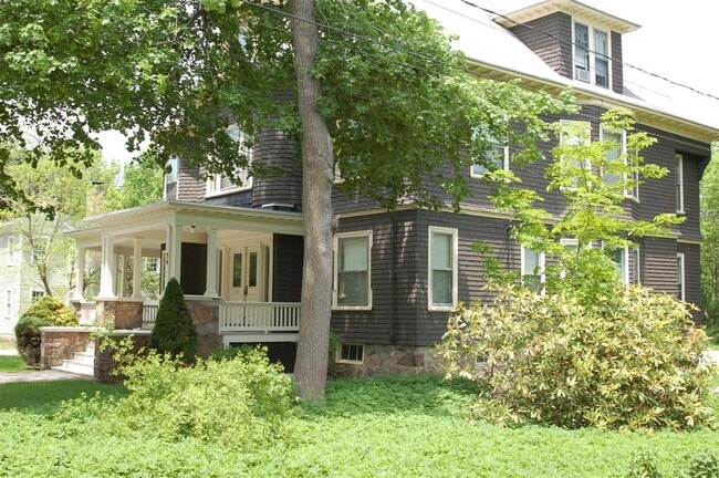
Property Record
54 Salem St, Andover, MA 01810

Save to a Folder
{{folder.Name}}
{{folder.ListingIds.length}} Properties
{{folder.ListingIds.length}} Property
Create a New Folder
Property Detail
54 Salem St
Apartment
Essex
SRB
Massachusetts
B and X Area of moderate flood hazard, usually the area between the limits of the 100-year and 500-year floods.
0.83 AC
2025
Andover
2025
Boston
254302
Boston-Cambridge-Newton, MA-NH
4,739 SF
ANDO-000041-000050
NEARBY LISTINGS FOR SALE OR LEASE
-
-
View all Andover listings for sale on LoopNet.com
DEMOGRAPHICS near 54 Salem St
1 mile
3 mile
5 mile
2025 Total Population
4,774
43,453
139,244
2030 Population
4,910
44,772
142,251
Pop Growth 2025-2030
+ 2.85%
+ 3.04%
+ 2.16%
Average Age
40
40
39
2025 Total Households
1,566
15,349
49,177
HH Growth 2025-2030
+ 2.81%
+ 3.00%
+ 2.33%
Median Household Inc
$198,275
$147,855
$102,160
Avg Household Size
2.70
2.60
2.70
2025 Avg HH Vehicles
2.00
2.00
2.00
Median Home Value
$870,677
$779,390
$702,172
Median Year Built
1957
1971
1968
Nearby Places
Map Layers
Map Styles
 Street
 Aerial
Layers
 Traffic
 Biking
Places
Listings with unknown addresses are not visible on the map
- Restaurants
- Banks
- Shops
- Fitness
- Groceries
PUBLIC TRANSPORTATION
COMMUTER RAIL
Andover (Haverhill Line - Massachusetts Bay Transportation Authority Commuter Rail (Purple Line))
Drive
Walk
Distance
Andover (Haverhill Line - Massachusetts Bay Transportation Authority Commuter Rail (Purple Line))
3 min
1.5 mi
Ballardvale (Haverhill Line - Massachusetts Bay Transportation Authority Commuter Rail (Purple Line))
Drive
Walk
Distance
Ballardvale (Haverhill Line - Massachusetts Bay Transportation Authority Commuter Rail (Purple Line))
7 min
2.7 mi
AIRPORT
General Edward Lawrence Logan International
Drive
Walk
Distance
General Edward Lawrence Logan International
38 min
25.6 mi
Manchester Boston Regional
Drive
Walk
Distance
Manchester Boston Regional
49 min
32.8 mi
Portsmouth International at Pease
Drive
Walk
Distance
Portsmouth International at Pease
55 min
41.5 mi
Nearby Properties
Address
Land Use
TOTAL SIZE
Lot Size
Zoning
Address
Land Use
TOTAL SIZE
Lot Size
Zoning
25.50 AC
IA
Address
Land Use
TOTAL SIZE
Lot Size
Zoning
9,576 SF
56.95 AC
R3
Address
Land Use
TOTAL SIZE
Lot Size
Zoning
3,111 SF
42.18 AC
R5
Address
Land Use
TOTAL SIZE
Lot Size
Zoning
11.11 AC
LS
Address
Land Use
TOTAL SIZE
Lot Size
Zoning
15,621 SF
34 AC
R5
Address
Land Use
TOTAL SIZE
Lot Size
Zoning
26.09 AC
R2
Address
Land Use
TOTAL SIZE
Lot Size
Zoning
314,278 SF
35.05 AC
SRB
Address
Land Use
TOTAL SIZE
Lot Size
Zoning
16.56 AC
Address
Land Use
TOTAL SIZE
Lot Size
Zoning
87.72 AC
SRB
Address
Land Use
TOTAL SIZE
Lot Size
Zoning
63.72 AC
IA
Address
Land Use
TOTAL SIZE
Lot Size
Zoning
4.33 AC
MU
Address
Land Use
TOTAL SIZE
Lot Size
Zoning
140,376 SF
135.08 AC
SRB
Address
Land Use
TOTAL SIZE
Lot Size
Zoning
7.13 AC
Address
Land Use
TOTAL SIZE
Lot Size
Zoning
3.50 AC
SRB
Address
Land Use
TOTAL SIZE
Lot Size
Zoning
8,738 SF
30.59 AC
R4
Address
Land Use
TOTAL SIZE
Lot Size
Zoning
28.05 AC
SRB
Address
Land Use
TOTAL SIZE
Lot Size
Zoning
169,008 SF
33.35 AC
VC
Address
Land Use
TOTAL SIZE
Lot Size
Zoning
150,000 SF
30.73 AC
LS
Address
Land Use
TOTAL SIZE
Lot Size
Zoning
129,522 SF
20.22 AC
SRB
Address
Land Use
TOTAL SIZE
Lot Size
Zoning
232,908 SF
12.74 AC
B3
Address
Land Use
TOTAL SIZE
Lot Size
Zoning
13.16 AC
IA
Address
Land Use
TOTAL SIZE
Lot Size
Zoning
30,240 SF
2.89 AC
LS
Address
Land Use
TOTAL SIZE
Lot Size
Zoning
81,975 SF
9.37 AC
SRB
Address
Land Use
TOTAL SIZE
Lot Size
Zoning
112,330 SF
17.06 AC
IA
Address
Land Use
TOTAL SIZE
Lot Size
Zoning
146,728 SF
8.93 AC
MU
Address
Land Use
TOTAL SIZE
Lot Size
Zoning
6,076 SF
13.56 AC
GB
Address
Land Use
TOTAL SIZE
Lot Size
Zoning
72,528 SF
15 AC
R2
Address
Land Use
TOTAL SIZE
Lot Size
Zoning
167,654 SF
14.84 AC
GI
Address
Land Use
TOTAL SIZE
Lot Size
Zoning
12.60 AC
MU
Address
Land Use
TOTAL SIZE
Lot Size
Zoning
8.32 AC
SRB
The World's #1 Commercial Real Estate Marketplace
Connect with us
© 2026 CoStar Group
The information above has been obtained from sources believed reliable. While we do not doubt its accuracy we have not verified it and make no guarantee, warranty or representation about it. It is your responsibility to independently confirm its accuracy and completeness. Any projections, opinions, assumptions, or estimates used are for example only and do not represent the current or future performance of the property. The value of this transaction to you depends on tax and other factors which should be evaluated by your tax, financial, and legal advisors. You and your advisors should conduct a careful, independent investigation of the property to determine to your satisfaction the suitability of the property for your needs.