Property Record
54 Whately Rd, South Deerfield, MA 01373
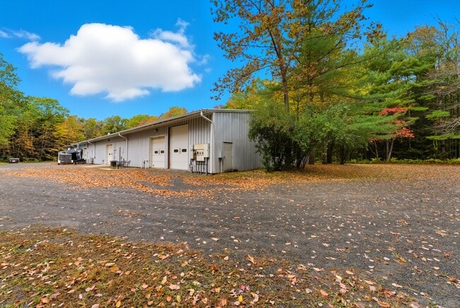
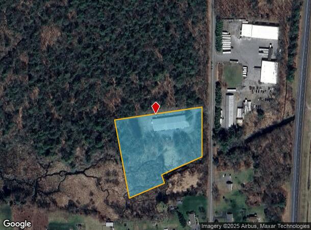
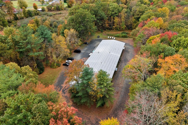
This Property Is For Sale
Current Lease Availabilities
NEARBY LISTINGS FOR SALE OR LEASE
Property Detail
54 Whately Rd
Greenfield Town, MA
David T & Dorothy A Frye
DEER-000167-000000-027002
Franklin
Officecondo
Massachusetts
2025
27.002
2025
Franklin County
040900
Hartford
3,006 SF
DEMOGRAPHICS near 54 Whately Rd
1 Mile
3 Mile
5 Mile
2024 Total Population
1,044
5,031
10,469
2029 Population
1,000
4,893
10,161
Pop Growth 2024-2029
(4.21%)
(2.74%)
(2.94%)
Average Age
46
44
44
2024 Total Households
456
2,211
4,588
HH Growth 2024-2029
(4.17%)
(2.71%)
(2.92%)
Median Household Inc
$81,801
$77,603
$80,791
Avg Household Size
2.20
2.20
2.20
2024 Avg HH Vehicles
2.00
2.00
2.00
Median Home Value
$376,190
$369,080
$365,756
Median Year Built
1968
1974
1974
Nearby Places
Map Layers
Map Styles
 Street
 Aerial
- Restaurants
- Banks
- Shops
- Fitness
- Groceries
PUBLIC TRANSPORTATION
COMMUTER RAIL
Greenfield Amtrak Station (Valley Flyer - Amtrak, Vermonter - Amtrak)
DRIVE
WALK
Distance
Greenfield Amtrak Station (Valley Flyer - Amtrak, Vermonter - Amtrak)
14 min
9.1 mi
Freight Ports
Albany, NY Port
DRIVE
WALK
Distance
Albany, NY Port
128 min
104.6 mi
Nearby Properties
Address
Land Use
TOTAL SIZE
Lot Size
Zoning
Address
Land Use
TOTAL SIZE
Lot Size
Zoning
20.89 AC
CVR
Address
Land Use
TOTAL SIZE
Lot Size
Zoning
256,340 SF
31.71 AC
I
Address
Land Use
TOTAL SIZE
Lot Size
Zoning
9.23 AC
CII
Address
Land Use
TOTAL SIZE
Lot Size
Zoning
18 AC
CVR
Address
Land Use
TOTAL SIZE
Lot Size
Zoning
9.12 AC
VR
Address
Land Use
TOTAL SIZE
Lot Size
Zoning
5.93 AC
VR
Address
Land Use
TOTAL SIZE
Lot Size
Zoning
208,790 SF
44 AC
CI
Address
Land Use
TOTAL SIZE
Lot Size
Zoning
71,742 SF
11.70 AC
CVR
Address
Land Use
TOTAL SIZE
Lot Size
Zoning
81,138 SF
10.21 AC
I
Address
Land Use
TOTAL SIZE
Lot Size
Zoning
243,750 SF
15.80 AC
MMO
Address
Land Use
TOTAL SIZE
Lot Size
Zoning
12.14 AC
I
Address
Land Use
TOTAL SIZE
Lot Size
Zoning
8.82 AC
MMO
Address
Land Use
TOTAL SIZE
Lot Size
Zoning
142,167 SF
10 AC
Address
Land Use
TOTAL SIZE
Lot Size
Zoning
61,950 SF
5.59 AC
CII
Address
Land Use
TOTAL SIZE
Lot Size
Zoning
3,444 SF
2.21 AC
RA
Address
Land Use
TOTAL SIZE
Lot Size
Zoning
42,903 SF
22.73 AC
C+I
Address
Land Use
TOTAL SIZE
Lot Size
Zoning
100,072 SF
7.97 AC
EP
Address
Land Use
TOTAL SIZE
Lot Size
Zoning
7.64 AC
MMO
Address
Land Use
TOTAL SIZE
Lot Size
Zoning
7.95 AC
I
Address
Land Use
TOTAL SIZE
Lot Size
Zoning
14.79 AC
R4
Address
Land Use
TOTAL SIZE
Lot Size
Zoning
12.70 AC
CVR
Address
Land Use
TOTAL SIZE
Lot Size
Zoning
990 SF
RRPA
Address
Land Use
TOTAL SIZE
Lot Size
Zoning
6.10 AC
CI
Address
Land Use
TOTAL SIZE
Lot Size
Zoning
60,000 SF
10.55 AC
I
Address
Land Use
TOTAL SIZE
Lot Size
Zoning
27,301 SF
10.40 AC
R4
Address
Land Use
TOTAL SIZE
Lot Size
Zoning
3.40 AC
CVR
Address
Land Use
TOTAL SIZE
Lot Size
Zoning
720 SF
85.39 AC
Address
Land Use
TOTAL SIZE
Lot Size
Zoning
10,297 SF
0.89 AC
VC
Address
Land Use
TOTAL SIZE
Lot Size
Zoning
2.51 AC
RRPA
Address
Land Use
TOTAL SIZE
Lot Size
Zoning
3,972 SF
3.15 AC
CII
The World's #1 Commercial Real Estate Marketplace
Connect with us
© 2025 CoStar Group
The information above has been obtained from sources believed reliable. While we do not doubt its accuracy we have not verified it and make no guarantee, warranty or representation about it. It is your responsibility to independently confirm its accuracy and completeness. Any projections, opinions, assumptions, or estimates used are for example only and do not represent the current or future performance of the property. The value of this transaction to you depends on tax and other factors which should be evaluated by your tax, financial, and legal advisors. You and your advisors should conduct a careful, independent investigation of the property to determine to your satisfaction the suitability of the property for your needs.