Property Record
540 B Rd, Labelle, FL 33935
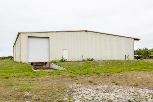


Property Detail
540 B Rd
1-29-43-27-010-0002-0151
33-43-29-010-0002-015.1 LA BELLE RANCHETTES UNREC TRACT 15 EXC BEG 30 FT N OF SE COR-W 200 FT-N 218 FT-E 200 FT-S 218 FT TO POB + EXC RD RWY 17.09 AC
Agriculturalland
Hendry
A-2
Florida
B and X Area of moderate flood hazard, usually the area between the limits of the 100-year and 500-year floods.
15
2025
17.09 AC
2025
Florida Central South Area
000300
Other Market Areas
13,864 SF
Clewiston, FL
NEARBY LISTINGS FOR SALE OR LEASE
-
-
View all Labelle listings for sale on LoopNet.com
DEMOGRAPHICS near 540 B Rd
1 mile
3 mile
5 mile
2025 Total Population
776
4,104
18,339
2030 Population
900
4,813
21,612
Pop Growth 2025-2030
+ 15.98%
+ 17.28%
+ 17.85%
Average Age
37
35
37
2025 Total Households
236
1,122
5,790
HH Growth 2025-2030
+ 17.80%
+ 19.43%
+ 19.55%
Median Household Inc
$50,256
$50,298
$49,892
Avg Household Size
2.90
3.10
3.00
2025 Avg HH Vehicles
2.00
2.00
2.00
Median Home Value
$192,423
$211,441
$236,550
Median Year Built
1994
1996
1990
Nearby Places
Map Layers
Map Styles
 Street
 Aerial
Layers
 Traffic
 Biking
Places
Listings with unknown addresses are not visible on the map
- Restaurants
- Banks
- Shops
- Fitness
- Groceries
PUBLIC TRANSPORTATION
AIRPORT
Southwest Florida International
Drive
Walk
Distance
Southwest Florida International
53 min
38.7 mi
Freight Ports
Port of Palm Beach
Drive
Walk
Distance
Port of Palm Beach
146 min
103.1 mi
SALE & LEASE HISTORY
LISTING DATE
SALE/LEASE

Feb 07, 2019
For Sale
Nearby Properties
Address
Land Use
TOTAL SIZE
Lot Size
Zoning
Address
Land Use
TOTAL SIZE
Lot Size
Zoning
216,868 SF
148.78 AC
LB-I-1
Address
Land Use
TOTAL SIZE
Lot Size
Zoning
75,810 SF
26.11 AC
RG4
Address
Land Use
TOTAL SIZE
Lot Size
Zoning
7,110 SF
30.37 AC
LB-PUD
Address
Land Use
TOTAL SIZE
Lot Size
Zoning
166,658 SF
16.86 AC
A-2
Address
Land Use
TOTAL SIZE
Lot Size
Zoning
28,236 SF
4.44 AC
LB-I-2
Address
Land Use
TOTAL SIZE
Lot Size
Zoning
227.41 AC
A-2
Address
Land Use
TOTAL SIZE
Lot Size
Zoning
225.87 AC
A-2
Address
Land Use
TOTAL SIZE
Lot Size
Zoning
28.74 AC
LB-I-1
Address
Land Use
TOTAL SIZE
Lot Size
Zoning
15,230 SF
1.50 AC
C-1
Address
Land Use
TOTAL SIZE
Lot Size
Zoning
73,392 SF
13.44 AC
A-2
Address
Land Use
TOTAL SIZE
Lot Size
Zoning
21,575 SF
5.04 AC
LB-I-2
Address
Land Use
TOTAL SIZE
Lot Size
Zoning
25,492 SF
1.84 AC
C-2
Address
Land Use
TOTAL SIZE
Lot Size
Zoning
576 SF
162.08 AC
PUD
Address
Land Use
TOTAL SIZE
Lot Size
Zoning
160 AC
A-2
Address
Land Use
TOTAL SIZE
Lot Size
Zoning
18,610 SF
268.42 AC
A-2
Address
Land Use
TOTAL SIZE
Lot Size
Zoning
13,600 SF
2.20 AC
LB-I-1
Address
Land Use
TOTAL SIZE
Lot Size
Zoning
3,360 SF
4.38 AC
I-2
Address
Land Use
TOTAL SIZE
Lot Size
Zoning
492.02 AC
A-2
Address
Land Use
TOTAL SIZE
Lot Size
Zoning
8,709 SF
1.47 AC
LB-I-2
Address
Land Use
TOTAL SIZE
Lot Size
Zoning
9,310 SF
2.08 AC
C-1
Address
Land Use
TOTAL SIZE
Lot Size
Zoning
8.24 AC
I-2
Address
Land Use
TOTAL SIZE
Lot Size
Zoning
18,088 SF
5.24 AC
A-2
Address
Land Use
TOTAL SIZE
Lot Size
Zoning
12,239 SF
9.22 AC
A-2
Address
Land Use
TOTAL SIZE
Lot Size
Zoning
5,700 SF
4.83 AC
A-2
Address
Land Use
TOTAL SIZE
Lot Size
Zoning
9,545 SF
5 AC
LB-I-2
Address
Land Use
TOTAL SIZE
Lot Size
Zoning
8.94 AC
LB-I-2
Address
Land Use
TOTAL SIZE
Lot Size
Zoning
8,203 SF
3.90 AC
C-1
Address
Land Use
TOTAL SIZE
Lot Size
Zoning
5,605 SF
2.64 AC
I-2
Address
Land Use
TOTAL SIZE
Lot Size
Zoning
4,090 SF
3.80 AC
RG2M
Address
Land Use
TOTAL SIZE
Lot Size
Zoning
5,600 SF
1.65 AC
I-2
The World's #1 Commercial Real Estate Marketplace
Connect with us
© 2026 CoStar Group
The information above has been obtained from sources believed reliable. While we do not doubt its accuracy we have not verified it and make no guarantee, warranty or representation about it. It is your responsibility to independently confirm its accuracy and completeness. Any projections, opinions, assumptions, or estimates used are for example only and do not represent the current or future performance of the property. The value of this transaction to you depends on tax and other factors which should be evaluated by your tax, financial, and legal advisors. You and your advisors should conduct a careful, independent investigation of the property to determine to your satisfaction the suitability of the property for your needs.