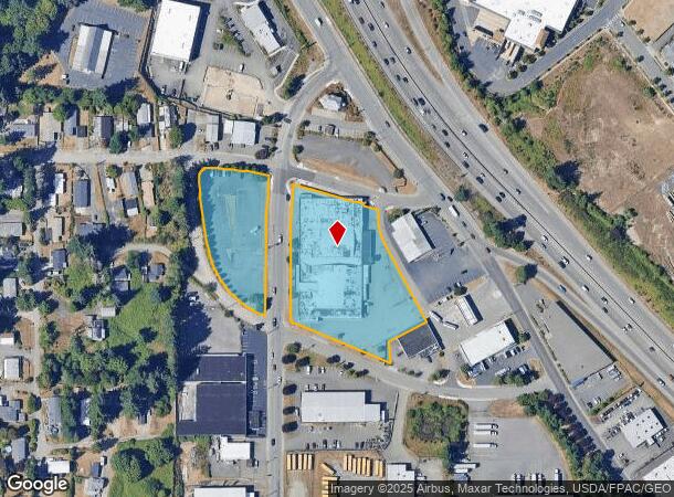
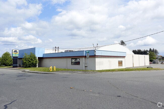
Property Record
540 Bruenn Ave, Bremerton, WA 98312

NEARBY LISTINGS FOR SALE OR LEASE
Property Detail
540 Bruenn Ave
Bremerton-Silverdale, WA
Qualheim
162401-4-078-2008
PARCEL 1: THAT PORTION OF THE SOUTHEAST QUARTER OF THE SOUTHWEST QUARTER, SECTION 16, TOWNSHIP 24 NORTH, RANGE 1 EAST, W.M., LYING WEST OF BRUENN AVENUE, SOUTH OF 5TH STREET, AND EASTERLY OF CASAD AVENUE, AS SHOWN ON PROPERTY LINE AND STREET MAP OF Q
Warehouse
Kitsap
X
Washington
53035C0360F
3.05 AC
0
West Bremerton
2026
Bremerton/Silverdale
080900
DEMOGRAPHICS near 540 Bruenn Ave
1 Mile
3 Mile
5 Mile
2024 Total Population
6,761
47,374
107,426
2029 Population
7,076
48,203
109,090
Pop Growth 2024-2029
+ 4.66%
+ 1.75%
+ 1.55%
Average Age
42
38
39
2024 Total Households
2,955
17,872
41,074
HH Growth 2024-2029
+ 4.81%
+ 2.10%
+ 1.70%
Median Household Inc
$54,700
$63,986
$69,115
Avg Household Size
2.20
2.30
2.40
2024 Avg HH Vehicles
2.00
2.00
2.00
Median Home Value
$446,111
$368,749
$395,159
Median Year Built
1990
1971
1978
Nearby Places
Map Layers
Map Styles
 Street
 Aerial
- Restaurants
- Banks
- Shops
- Fitness
- Groceries
SALE & LEASE HISTORY
LISTING DATE
SALE/LEASE

Sep 24, 2016
For Sale
Oct 20, 2016
For Sale
Nearby Properties
Address
Land Use
TOTAL SIZE
Lot Size
Zoning
Address
Land Use
TOTAL SIZE
Lot Size
Zoning
21,408 SF
8.26 AC
BVSAP
Address
Land Use
TOTAL SIZE
Lot Size
Zoning
138,877 SF
7.17 AC
R-10
Address
Land Use
TOTAL SIZE
Lot Size
Zoning
66,022 SF
8.28 AC
RR
Address
Land Use
TOTAL SIZE
Lot Size
Zoning
112,847 SF
6.80 AC
UM
Address
Land Use
TOTAL SIZE
Lot Size
Zoning
151,599 SF
5.44 AC
R-40
Address
Land Use
TOTAL SIZE
Lot Size
Zoning
Address
Land Use
TOTAL SIZE
Lot Size
Zoning
79,615 SF
1.25 AC
DSAP
Address
Land Use
TOTAL SIZE
Lot Size
Zoning
75,390 SF
4.46 AC
R-18
Address
Land Use
TOTAL SIZE
Lot Size
Zoning
122,799 SF
4.48 AC
R-40
Address
Land Use
TOTAL SIZE
Lot Size
Zoning
68,079 SF
2.16 AC
BVSAP
Address
Land Use
TOTAL SIZE
Lot Size
Zoning
73,931 SF
11.72 AC
FC
Address
Land Use
TOTAL SIZE
Lot Size
Zoning
43,944 SF
2.64 AC
FC
Address
Land Use
TOTAL SIZE
Lot Size
Zoning
47,584 SF
3.76 AC
R-40
Address
Land Use
TOTAL SIZE
Lot Size
Zoning
45,682 SF
2.04 AC
GC
Address
Land Use
TOTAL SIZE
Lot Size
Zoning
75,225 SF
3.30 AC
R-10
Address
Land Use
TOTAL SIZE
Lot Size
Zoning
55,866 SF
8.48 AC
FC
Address
Land Use
TOTAL SIZE
Lot Size
Zoning
48,520 SF
3.76 AC
GC
Address
Land Use
TOTAL SIZE
Lot Size
Zoning
44,220 SF
2.86 AC
R-40
Address
Land Use
TOTAL SIZE
Lot Size
Zoning
60,977 SF
0.47 AC
DSAP
Address
Land Use
TOTAL SIZE
Lot Size
Zoning
24,930 SF
0.33 AC
DSAP
Address
Land Use
TOTAL SIZE
Lot Size
Zoning
38,502 SF
5.92 AC
R-40
Address
Land Use
TOTAL SIZE
Lot Size
Zoning
52,461 SF
5.92 AC
RR
Address
Land Use
TOTAL SIZE
Lot Size
Zoning
46,976 SF
0.93 AC
EC
Address
Land Use
TOTAL SIZE
Lot Size
Zoning
42,665 SF
5.55 AC
FC
Address
Land Use
TOTAL SIZE
Lot Size
Zoning
51,933 SF
4.07 AC
C
Address
Land Use
TOTAL SIZE
Lot Size
Zoning
75,000 SF
3.61 AC
LI
Address
Land Use
TOTAL SIZE
Lot Size
Zoning
52,601 SF
6.30 AC
BVSAP
Address
Land Use
TOTAL SIZE
Lot Size
Zoning
47,064 SF
5.27 AC
GC
Address
Land Use
TOTAL SIZE
Lot Size
Zoning
48,130 SF
0.42 AC
DSAP
Address
Land Use
TOTAL SIZE
Lot Size
Zoning
74,169 SF
2.62 AC
GC
The World's #1 Commercial Real Estate Marketplace
Connect with us
© 2025 CoStar Group
The information above has been obtained from sources believed reliable. While we do not doubt its accuracy we have not verified it and make no guarantee, warranty or representation about it. It is your responsibility to independently confirm its accuracy and completeness. Any projections, opinions, assumptions, or estimates used are for example only and do not represent the current or future performance of the property. The value of this transaction to you depends on tax and other factors which should be evaluated by your tax, financial, and legal advisors. You and your advisors should conduct a careful, independent investigation of the property to determine to your satisfaction the suitability of the property for your needs.