Property Record
540 E Main St, Pahokee, FL 33476
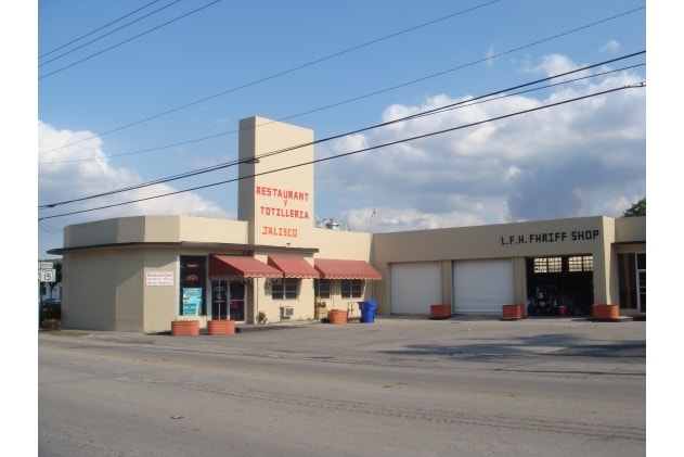


Property Detail
540 E Main St
48-37-42-17-02-002-0010
OKEELANTA PLANTATION COS SUB LTS 1 & 2 & SWLY 25 FT OF LT 3 BLK 2
Departmentstore
Palm Beach
CORE
Florida
B and X Area of moderate flood hazard, usually the area between the limits of the 100-year and 500-year floods.
1,2,3
2024
0.91 AC
2025
Palm Bch Cty Outlying
008002
South Florida
9,173 SF
West Palm Beach-Boca Raton-Delray Beach, FL
NEARBY LISTINGS FOR SALE OR LEASE
-
-
View all Pahokee listings for sale on LoopNet.com
DEMOGRAPHICS near 540 E Main St
1 mile
3 mile
5 mile
2025 Total Population
3,832
8,279
8,889
2030 Population
4,139
8,870
9,526
Pop Growth 2025-2030
+ 8.01%
+ 7.14%
+ 7.17%
Average Age
37
36
36
2025 Total Households
1,215
2,683
2,819
HH Growth 2025-2030
+ 7.49%
+ 6.63%
+ 6.70%
Median Household Inc
$58,014
$38,350
$38,840
Avg Household Size
3.00
2.90
2.90
2025 Avg HH Vehicles
2.00
1.00
1.00
Median Home Value
$191,802
$152,801
$150,406
Median Year Built
1973
1974
1974
Nearby Places
Map Layers
Map Styles
 Street
 Aerial
Layers
 Traffic
 Biking
Places
Listings with unknown addresses are not visible on the map
- Restaurants
- Banks
- Shops
- Fitness
- Groceries
Nearby Properties
Address
Land Use
TOTAL SIZE
Lot Size
Zoning
Address
Land Use
TOTAL SIZE
Lot Size
Zoning
198,172 SF
15.08 AC
PF
Address
Land Use
TOTAL SIZE
Lot Size
Zoning
97,658 SF
19.97 AC
AP
Address
Land Use
TOTAL SIZE
Lot Size
Zoning
164,185 SF
33.70 AC
PF
Address
Land Use
TOTAL SIZE
Lot Size
Zoning
197,175 SF
23.70 AC
RH
Address
Land Use
TOTAL SIZE
Lot Size
Zoning
33,656 SF
9.97 AC
PUD
Address
Land Use
TOTAL SIZE
Lot Size
Zoning
10,513 SF
33.29 AC
WOR
Address
Land Use
TOTAL SIZE
Lot Size
Zoning
28,878 SF
2.47 AC
SFMU
Address
Land Use
TOTAL SIZE
Lot Size
Zoning
67,866 SF
11.05 AC
RM
Address
Land Use
TOTAL SIZE
Lot Size
Zoning
47,310 SF
7.65 AC
RH
Address
Land Use
TOTAL SIZE
Lot Size
Zoning
49,753 SF
8.67 AC
CORE
Address
Land Use
TOTAL SIZE
Lot Size
Zoning
74,714 SF
10.87 AC
RM
Address
Land Use
TOTAL SIZE
Lot Size
Zoning
12,587 SF
15.02 AC
AG
Address
Land Use
TOTAL SIZE
Lot Size
Zoning
31,532 SF
2.42 AC
PF
Address
Land Use
TOTAL SIZE
Lot Size
Zoning
8,821 SF
2.68 AC
AG
Address
Land Use
TOTAL SIZE
Lot Size
Zoning
72,518 SF
7.06 AC
RH
Address
Land Use
TOTAL SIZE
Lot Size
Zoning
7,690 SF
2.53 AC
PF
Address
Land Use
TOTAL SIZE
Lot Size
Zoning
15,322 SF
5.69 AC
SF1
Address
Land Use
TOTAL SIZE
Lot Size
Zoning
42,042 SF
5.67 AC
MF12
Address
Land Use
TOTAL SIZE
Lot Size
Zoning
19,054 SF
2.86 AC
SFMU
Address
Land Use
TOTAL SIZE
Lot Size
Zoning
14,940 SF
1.90 AC
CORE
Address
Land Use
TOTAL SIZE
Lot Size
Zoning
5,379 SF
0.98 AC
CORE
Address
Land Use
TOTAL SIZE
Lot Size
Zoning
18,600 SF
0.52 AC
GC
Address
Land Use
TOTAL SIZE
Lot Size
Zoning
18,380 SF
2.60 AC
NC
Address
Land Use
TOTAL SIZE
Lot Size
Zoning
8,577 SF
0.84 AC
CORE
Address
Land Use
TOTAL SIZE
Lot Size
Zoning
10,652 SF
0.85 AC
LI
Address
Land Use
TOTAL SIZE
Lot Size
Zoning
34,242 SF
2.64 AC
MF18
Address
Land Use
TOTAL SIZE
Lot Size
Zoning
19,168 SF
0.65 AC
CORE
Address
Land Use
TOTAL SIZE
Lot Size
Zoning
13,965 SF
1 AC
SF7
Address
Land Use
TOTAL SIZE
Lot Size
Zoning
10,497 SF
0.99 AC
AG
The World's #1 Commercial Real Estate Marketplace
Connect with us
© 2026 CoStar Group
The information above has been obtained from sources believed reliable. While we do not doubt its accuracy we have not verified it and make no guarantee, warranty or representation about it. It is your responsibility to independently confirm its accuracy and completeness. Any projections, opinions, assumptions, or estimates used are for example only and do not represent the current or future performance of the property. The value of this transaction to you depends on tax and other factors which should be evaluated by your tax, financial, and legal advisors. You and your advisors should conduct a careful, independent investigation of the property to determine to your satisfaction the suitability of the property for your needs.