Property Record
540 Folly Rd, Charleston, SC 29412


Save to a Folder
{{folder.Name}}
{{folder.ListingIds.length}} Properties
{{folder.ListingIds.length}} Property
Create a New Folder
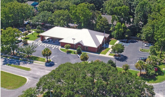
Property Detail
540 Folly Rd
340-00-00-064
SUBDIVISION NAME -OLD TOWN DESCRIPTION -PARCEL 6A SITE NAME -SOUTHTRUST
Officebuilding
Charleston
AE The base floodplain where base flood elevations are provided. AE Zones are now used on new format FIRMs instead of A1-A30 Zones.
South Carolina
2025
1.11 AC
2024
James Island/Folly Beach
001902
Charleston/N Charleston
4,250 SF
Charleston-North Charleston, SC
NEARBY LISTINGS FOR SALE OR LEASE
DEMOGRAPHICS near 540 Folly Rd
1 mile
3 mile
5 mile
2025 Total Population
6,811
49,002
116,996
2030 Population
7,118
50,929
122,183
Pop Growth 2025-2030
+ 4.51%
+ 3.93%
+ 4.43%
Average Age
39
41
40
2025 Total Households
3,433
22,939
52,755
HH Growth 2025-2030
+ 4.57%
+ 4.11%
+ 4.64%
Median Household Inc
$81,576
$101,050
$91,675
Avg Household Size
2.00
2.10
2.10
2025 Avg HH Vehicles
2.00
2.00
2.00
Median Home Value
$497,593
$572,945
$543,286
Median Year Built
1988
1977
1976
Nearby Places
Map Layers
Map Styles
 Street
 Aerial
Layers
 Traffic
 Biking
Places
Listings with unknown addresses are not visible on the map
- Restaurants
- Banks
- Shops
- Fitness
- Groceries
PUBLIC TRANSPORTATION
COMMUTER RAIL
Drive
Walk
Distance
18 min
10.0 mi
AIRPORT
Charleston AFB/International
Drive
Walk
Distance
Charleston AFB/International
28 min
15.4 mi
Freight Ports
Columbus Street Terminal
Drive
Walk
Distance
Columbus Street Terminal
10 min
4.9 mi
SALE & LEASE HISTORY
LISTING DATE
SALE/LEASE

Sep 05, 2018
For Sale
Sep 04, 2018
For Sale
Oct 11, 2018
For Sale
Nov 09, 2020
For Sale
Nov 02, 2018
For Sale
Mar 08, 2018
For Sale
Jan 29, 2019
For Sale
Feb 21, 2018
For Sale
Aug 28, 2018
For Sale
Aug 03, 2018
For Sale
Nearby Properties
Address
Land Use
TOTAL SIZE
Lot Size
Zoning
Address
Land Use
TOTAL SIZE
Lot Size
Zoning
0.62 AC
Address
Land Use
TOTAL SIZE
Lot Size
Zoning
80,044 SF
2.48 AC
Address
Land Use
TOTAL SIZE
Lot Size
Zoning
66,136 SF
1.88 AC
Address
Land Use
TOTAL SIZE
Lot Size
Zoning
3,780 SF
14.35 AC
Address
Land Use
TOTAL SIZE
Lot Size
Zoning
17,459 SF
4.16 AC
Address
Land Use
TOTAL SIZE
Lot Size
Zoning
8,714 SF
1.60 AC
Address
Land Use
TOTAL SIZE
Lot Size
Zoning
Address
Land Use
TOTAL SIZE
Lot Size
Zoning
Address
Land Use
TOTAL SIZE
Lot Size
Zoning
Address
Land Use
TOTAL SIZE
Lot Size
Zoning
22,825 SF
4.36 AC
Address
Land Use
TOTAL SIZE
Lot Size
Zoning
257,500 SF
4.72 AC
Address
Land Use
TOTAL SIZE
Lot Size
Zoning
12,766 SF
1.72 AC
Address
Land Use
TOTAL SIZE
Lot Size
Zoning
Address
Land Use
TOTAL SIZE
Lot Size
Zoning
Address
Land Use
TOTAL SIZE
Lot Size
Zoning
7.09 AC
Address
Land Use
TOTAL SIZE
Lot Size
Zoning
1,056 SF
1.65 AC
Address
Land Use
TOTAL SIZE
Lot Size
Zoning
0.84 AC
Address
Land Use
TOTAL SIZE
Lot Size
Zoning
Address
Land Use
TOTAL SIZE
Lot Size
Zoning
1,793 SF
Address
Land Use
TOTAL SIZE
Lot Size
Zoning
1.08 AC
Address
Land Use
TOTAL SIZE
Lot Size
Zoning
25,860 SF
0.78 AC
Address
Land Use
TOTAL SIZE
Lot Size
Zoning
172,224 SF
7.35 AC
Address
Land Use
TOTAL SIZE
Lot Size
Zoning
4,421 SF
0.24 AC
Address
Land Use
TOTAL SIZE
Lot Size
Zoning
3,208 SF
1.48 AC
Address
Land Use
TOTAL SIZE
Lot Size
Zoning
16,775 SF
5.93 AC
Address
Land Use
TOTAL SIZE
Lot Size
Zoning
Address
Land Use
TOTAL SIZE
Lot Size
Zoning
20,845 SF
1.28 AC
Address
Land Use
TOTAL SIZE
Lot Size
Zoning
563 SF
0.91 AC
Address
Land Use
TOTAL SIZE
Lot Size
Zoning
105,816 SF
16.34 AC
Address
Land Use
TOTAL SIZE
Lot Size
Zoning
7,722 SF
20.48 AC
The World's #1 Commercial Real Estate Marketplace
Connect with us
© 2026 CoStar Group
The information above has been obtained from sources believed reliable. While we do not doubt its accuracy we have not verified it and make no guarantee, warranty or representation about it. It is your responsibility to independently confirm its accuracy and completeness. Any projections, opinions, assumptions, or estimates used are for example only and do not represent the current or future performance of the property. The value of this transaction to you depends on tax and other factors which should be evaluated by your tax, financial, and legal advisors. You and your advisors should conduct a careful, independent investigation of the property to determine to your satisfaction the suitability of the property for your needs.