Property Record
540 Gateway Ave, Chambersburg, PA 17201

Save to a Folder
{{folder.Name}}
{{folder.ListingIds.length}} Properties
{{folder.ListingIds.length}} Property
Create a New Folder
Property Detail
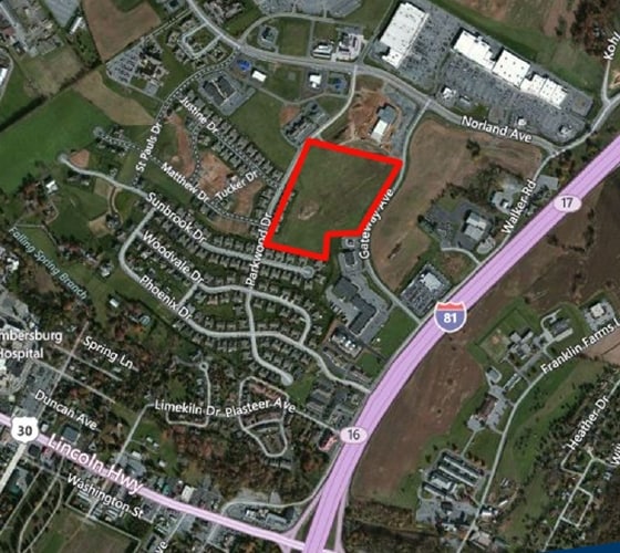
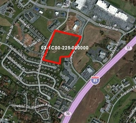
540 Gateway Ave
Chambersburg, PA
LOTS I10,I11A,I12A,I12,I13
03-1C00-225-000000
Franklin
Storebuilding
Pennsylvania
B and X Area of moderate flood hazard, usually the area between the limits of the 100-year and 500-year floods.
i10
2026
20.29 AC
2026
Chambersburg/Waynesboro
010900
Philadelphia
NEARBY LISTINGS FOR SALE OR LEASE
DEMOGRAPHICS near 540 Gateway Ave
1 mile
3 mile
5 mile
2025 Total Population
3,772
37,819
57,020
2030 Population
3,840
38,625
58,173
Pop Growth 2025-2030
+ 1.80%
+ 2.13%
+ 2.02%
Average Age
44
42
42
2025 Total Households
1,609
15,342
22,788
HH Growth 2025-2030
+ 1.62%
+ 2.08%
+ 2.00%
Median Household Inc
$70,710
$66,690
$71,375
Avg Household Size
2.20
2.30
2.40
2025 Avg HH Vehicles
2.00
2.00
2.00
Median Home Value
$288,379
$244,114
$251,998
Median Year Built
1970
1975
1978
Nearby Places
Map Layers
Map Styles
 Street
 Aerial
Layers
 Traffic
 Biking
Places
Listings with unknown addresses are not visible on the map
- Restaurants
- Banks
- Shops
- Fitness
- Groceries
PUBLIC TRANSPORTATION
AIRPORT
Hagerstown Regional/Richard A Henson Field
Drive
Walk
Distance
Hagerstown Regional/Richard A Henson Field
27 min
20.4 mi
Freight Ports
Port of Baltimore
Drive
Walk
Distance
Port of Baltimore
123 min
103.2 mi
SALE & LEASE HISTORY
LISTING DATE
SALE/LEASE

Sep 25, 2016
For Lease
Nearby Properties
Address
Land Use
TOTAL SIZE
Lot Size
Zoning
Address
Land Use
TOTAL SIZE
Lot Size
Zoning
20.05 AC
Address
Land Use
TOTAL SIZE
Lot Size
Zoning
Address
Land Use
TOTAL SIZE
Lot Size
Zoning
Address
Land Use
TOTAL SIZE
Lot Size
Zoning
Address
Land Use
TOTAL SIZE
Lot Size
Zoning
53.99 AC
Address
Land Use
TOTAL SIZE
Lot Size
Zoning
60.88 AC
Address
Land Use
TOTAL SIZE
Lot Size
Zoning
20.58 AC
Address
Land Use
TOTAL SIZE
Lot Size
Zoning
71.80 AC
Address
Land Use
TOTAL SIZE
Lot Size
Zoning
39.37 AC
Address
Land Use
TOTAL SIZE
Lot Size
Zoning
36.91 AC
Address
Land Use
TOTAL SIZE
Lot Size
Zoning
121.20 AC
Address
Land Use
TOTAL SIZE
Lot Size
Zoning
Address
Land Use
TOTAL SIZE
Lot Size
Zoning
36.53 AC
Address
Land Use
TOTAL SIZE
Lot Size
Zoning
184.41 AC
Address
Land Use
TOTAL SIZE
Lot Size
Zoning
Address
Land Use
TOTAL SIZE
Lot Size
Zoning
47.56 AC
Address
Land Use
TOTAL SIZE
Lot Size
Zoning
37.36 AC
Address
Land Use
TOTAL SIZE
Lot Size
Zoning
25.25 AC
Address
Land Use
TOTAL SIZE
Lot Size
Zoning
Address
Land Use
TOTAL SIZE
Lot Size
Zoning
30.89 AC
Address
Land Use
TOTAL SIZE
Lot Size
Zoning
Address
Land Use
TOTAL SIZE
Lot Size
Zoning
Address
Land Use
TOTAL SIZE
Lot Size
Zoning
25.15 AC
Address
Land Use
TOTAL SIZE
Lot Size
Zoning
12.78 AC
Address
Land Use
TOTAL SIZE
Lot Size
Zoning
Address
Land Use
TOTAL SIZE
Lot Size
Zoning
17.04 AC
Address
Land Use
TOTAL SIZE
Lot Size
Zoning
14.94 AC
Address
Land Use
TOTAL SIZE
Lot Size
Zoning
Address
Land Use
TOTAL SIZE
Lot Size
Zoning
Address
Land Use
TOTAL SIZE
Lot Size
Zoning
12.95 AC
The World's #1 Commercial Real Estate Marketplace
Connect with us
© 2026 CoStar Group
The information above has been obtained from sources believed reliable. While we do not doubt its accuracy we have not verified it and make no guarantee, warranty or representation about it. It is your responsibility to independently confirm its accuracy and completeness. Any projections, opinions, assumptions, or estimates used are for example only and do not represent the current or future performance of the property. The value of this transaction to you depends on tax and other factors which should be evaluated by your tax, financial, and legal advisors. You and your advisors should conduct a careful, independent investigation of the property to determine to your satisfaction the suitability of the property for your needs.