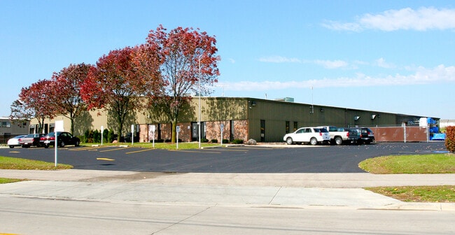
Property Record
540 Linnerud Dr, Sun Prairie, WI 53590

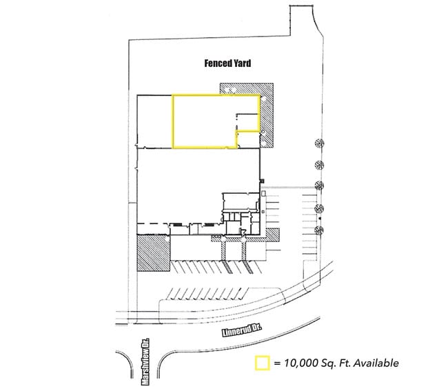
Current Lease Availabilities
NEARBY LISTINGS FOR SALE OR LEASE
Property Detail
540 Linnerud Dr
Madison, WI
Foulke Industrial Park
0811-082-5723-9
FOULKE INDUSTRIAL PARK LOT 3 & THAT PRT LOT 1 CSM 4772 CS21/107&108-10/2/85 DESC R AS BEG NE COR SD LOT 3 TH N88DEG0205E 50.04 FT TH S00DEG3038W 322.75 FT TO LINNERUD DR N LN TH ALG CRV TO R RAD 326 FT L/C S60DEG1138W 58 FT TO SE COR S D LOT 3 TH N00
Commercialnec
Dane
X
Wisconsin
55025C0286H
3,1
2024
2.26 AC
2024
Northeast Madison
011506
Milwaukee/Madison
33,024 SF
DEMOGRAPHICS near 540 Linnerud Dr
1 Mile
3 Mile
5 Mile
2024 Total Population
8,447
39,355
56,078
2029 Population
8,810
40,891
58,367
Pop Growth 2024-2029
+ 4.30%
+ 3.90%
+ 4.08%
Average Age
38
38
38
2024 Total Households
3,458
15,684
22,809
HH Growth 2024-2029
+ 4.42%
+ 4.07%
+ 4.29%
Median Household Inc
$61,037
$86,412
$86,902
Avg Household Size
2.30
2.50
2.40
2024 Avg HH Vehicles
2.00
2.00
2.00
Median Home Value
$248,600
$317,432
$319,351
Median Year Built
1977
1995
1996
Nearby Places
Map Layers
Map Styles
 Street
 Aerial
- Restaurants
- Banks
- Shops
- Fitness
- Groceries
PUBLIC TRANSPORTATION
AIRPORT
Dane County Regional/Truax Field
DRIVE
WALK
Distance
Dane County Regional/Truax Field
20 min
10.4 mi
Nearby Properties
Address
Land Use
TOTAL SIZE
Lot Size
Zoning
Address
Land Use
TOTAL SIZE
Lot Size
Zoning
8.49 AC
SFR
Address
Land Use
TOTAL SIZE
Lot Size
Zoning
Address
Land Use
TOTAL SIZE
Lot Size
Zoning
58,272 SF
136.54 AC
SO
Address
Land Use
TOTAL SIZE
Lot Size
Zoning
8.56 AC
Address
Land Use
TOTAL SIZE
Lot Size
Zoning
26.32 AC
Address
Land Use
TOTAL SIZE
Lot Size
Zoning
4.64 AC
Address
Land Use
TOTAL SIZE
Lot Size
Zoning
31,986 SF
5 AC
PD
Address
Land Use
TOTAL SIZE
Lot Size
Zoning
46,902 SF
5.28 AC
PD
Address
Land Use
TOTAL SIZE
Lot Size
Zoning
222,532 SF
18.02 AC
PD
Address
Land Use
TOTAL SIZE
Lot Size
Zoning
Address
Land Use
TOTAL SIZE
Lot Size
Zoning
3.03 AC
RH-35
Address
Land Use
TOTAL SIZE
Lot Size
Zoning
Address
Land Use
TOTAL SIZE
Lot Size
Zoning
70,080 SF
3.21 AC
Address
Land Use
TOTAL SIZE
Lot Size
Zoning
26,854 SF
8.25 AC
UR12
Address
Land Use
TOTAL SIZE
Lot Size
Zoning
147,310 SF
14.68 AC
SC
Address
Land Use
TOTAL SIZE
Lot Size
Zoning
12.16 AC
Address
Land Use
TOTAL SIZE
Lot Size
Zoning
Address
Land Use
TOTAL SIZE
Lot Size
Zoning
152,636 SF
13.28 AC
Address
Land Use
TOTAL SIZE
Lot Size
Zoning
72,072 SF
11.78 AC
Address
Land Use
TOTAL SIZE
Lot Size
Zoning
Address
Land Use
TOTAL SIZE
Lot Size
Zoning
84,541 SF
10.54 AC
PD
Address
Land Use
TOTAL SIZE
Lot Size
Zoning
430,172 SF
18.33 AC
SI
Address
Land Use
TOTAL SIZE
Lot Size
Zoning
Address
Land Use
TOTAL SIZE
Lot Size
Zoning
11.28 AC
Address
Land Use
TOTAL SIZE
Lot Size
Zoning
15.38 AC
Address
Land Use
TOTAL SIZE
Lot Size
Zoning
133,853 SF
12.95 AC
PD
Address
Land Use
TOTAL SIZE
Lot Size
Zoning
22,866 SF
5.39 AC
PD
Address
Land Use
TOTAL SIZE
Lot Size
Zoning
16,464 SF
7.37 AC
UR12
Address
Land Use
TOTAL SIZE
Lot Size
Zoning
2.80 AC
PD
Address
Land Use
TOTAL SIZE
Lot Size
Zoning
55,581 SF
3.35 AC
PD
The World's #1 Commercial Real Estate Marketplace
Connect with us
© 2026 CoStar Group
The information above has been obtained from sources believed reliable. While we do not doubt its accuracy we have not verified it and make no guarantee, warranty or representation about it. It is your responsibility to independently confirm its accuracy and completeness. Any projections, opinions, assumptions, or estimates used are for example only and do not represent the current or future performance of the property. The value of this transaction to you depends on tax and other factors which should be evaluated by your tax, financial, and legal advisors. You and your advisors should conduct a careful, independent investigation of the property to determine to your satisfaction the suitability of the property for your needs.