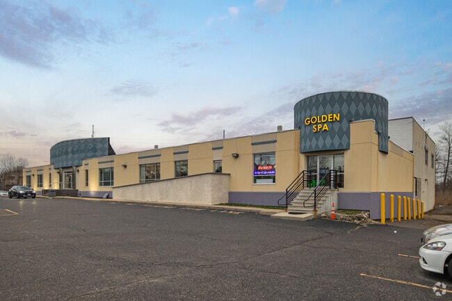
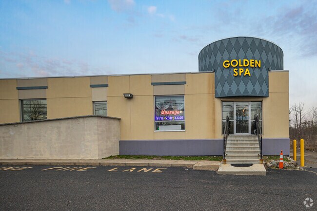
Property Record
540 Main St, Tewksbury, MA 01876

NEARBY LISTINGS FOR SALE OR LEASE
Property Detail
540 Main St
TEWK-000035-000000-000003
Middlesex
Gymhealthspa
Massachusetts
A
3
25017C0257G
2.37 AC
2025
Lowell/Chelmsford
2025
Boston
315100
Boston-Cambridge-Newton, MA-NH
20,094 SF
DEMOGRAPHICS near 540 Main St
1 Mile
3 Mile
5 Mile
2024 Total Population
3,814
56,788
190,266
2029 Population
3,784
56,074
187,535
Pop Growth 2024-2029
(0.79%)
(1.26%)
(1.44%)
Average Age
44
41
40
2024 Total Households
1,457
21,311
68,503
HH Growth 2024-2029
(0.75%)
(1.36%)
(1.48%)
Median Household Inc
$111,697
$98,088
$89,712
Avg Household Size
2.50
2.60
2.60
2024 Avg HH Vehicles
2.00
2.00
2.00
Median Home Value
$600,818
$458,622
$455,656
Median Year Built
1985
1972
1964
Nearby Places
Map Layers
Map Styles
 Street
 Aerial
- Restaurants
- Banks
- Shops
- Fitness
- Groceries
PUBLIC TRANSPORTATION
COMMUTER RAIL
North Billerica (Lowell Line - Massachusetts Bay Transportation Authority Commuter Rail (Purple Line))
DRIVE
WALK
Distance
North Billerica (Lowell Line - Massachusetts Bay Transportation Authority Commuter Rail (Purple Line))
11 min
4.4 mi
Ballardvale (Haverhill Line - Massachusetts Bay Transportation Authority Commuter Rail (Purple Line))
DRIVE
WALK
Distance
Ballardvale (Haverhill Line - Massachusetts Bay Transportation Authority Commuter Rail (Purple Line))
15 min
5.6 mi
AIRPORT
General Edward Lawrence Logan International
DRIVE
WALK
Distance
General Edward Lawrence Logan International
38 min
31.2 mi
Manchester Boston Regional
DRIVE
WALK
Distance
Manchester Boston Regional
44 min
34.2 mi
SALE & LEASE HISTORY
LISTING DATE
SALE/LEASE

Sep 23, 2022
For Sale
Apr 11, 2022
For Lease
Nearby Properties
Address
Land Use
TOTAL SIZE
Lot Size
Zoning
Address
Land Use
TOTAL SIZE
Lot Size
Zoning
52.80 AC
OR
Address
Land Use
TOTAL SIZE
Lot Size
Zoning
Address
Land Use
TOTAL SIZE
Lot Size
Zoning
25 AC
MN
Address
Land Use
TOTAL SIZE
Lot Size
Zoning
1,616 SF
206.08 AC
R40
Address
Land Use
TOTAL SIZE
Lot Size
Zoning
11.45 AC
TTF
Address
Land Use
TOTAL SIZE
Lot Size
Zoning
19.04 AC
MFD
Address
Land Use
TOTAL SIZE
Lot Size
Zoning
15.16 AC
SMF
Address
Land Use
TOTAL SIZE
Lot Size
Zoning
67.55 AC
OR
Address
Land Use
TOTAL SIZE
Lot Size
Zoning
396,990 SF
48.84 AC
IH
Address
Land Use
TOTAL SIZE
Lot Size
Zoning
218,780 SF
55.49 AC
MN
Address
Land Use
TOTAL SIZE
Lot Size
Zoning
380,132 SF
35.87 AC
5
Address
Land Use
TOTAL SIZE
Lot Size
Zoning
152,040 SF
9.10 AC
SRC
Address
Land Use
TOTAL SIZE
Lot Size
Zoning
40.44 AC
MFD
Address
Land Use
TOTAL SIZE
Lot Size
Zoning
13.74 AC
SSF
Address
Land Use
TOTAL SIZE
Lot Size
Zoning
484,857 SF
42.05 AC
HI
Address
Land Use
TOTAL SIZE
Lot Size
Zoning
9.80 AC
R40
Address
Land Use
TOTAL SIZE
Lot Size
Zoning
113,912 SF
5.67 AC
MFD
Address
Land Use
TOTAL SIZE
Lot Size
Zoning
107,001 SF
21.82 AC
MN
Address
Land Use
TOTAL SIZE
Lot Size
Zoning
172,622 SF
22.32 AC
COM
Address
Land Use
TOTAL SIZE
Lot Size
Zoning
135,500 SF
17.96 AC
OR
Address
Land Use
TOTAL SIZE
Lot Size
Zoning
84,282 SF
23.15 AC
SSF
Address
Land Use
TOTAL SIZE
Lot Size
Zoning
73.74 AC
IH
Address
Land Use
TOTAL SIZE
Lot Size
Zoning
5.26 AC
SMF
Address
Land Use
TOTAL SIZE
Lot Size
Zoning
84.43 AC
SSF
Address
Land Use
TOTAL SIZE
Lot Size
Zoning
3.75 AC
UMF
Address
Land Use
TOTAL SIZE
Lot Size
Zoning
Address
Land Use
TOTAL SIZE
Lot Size
Zoning
98,247 SF
17.74 AC
5
Address
Land Use
TOTAL SIZE
Lot Size
Zoning
14.31 AC
5
Address
Land Use
TOTAL SIZE
Lot Size
Zoning
85,400 SF
21.96 AC
DMU
Address
Land Use
TOTAL SIZE
Lot Size
Zoning
92,380 SF
2.66 AC
COM
The World's #1 Commercial Real Estate Marketplace
Connect with us
© 2025 CoStar Group
The information above has been obtained from sources believed reliable. While we do not doubt its accuracy we have not verified it and make no guarantee, warranty or representation about it. It is your responsibility to independently confirm its accuracy and completeness. Any projections, opinions, assumptions, or estimates used are for example only and do not represent the current or future performance of the property. The value of this transaction to you depends on tax and other factors which should be evaluated by your tax, financial, and legal advisors. You and your advisors should conduct a careful, independent investigation of the property to determine to your satisfaction the suitability of the property for your needs.