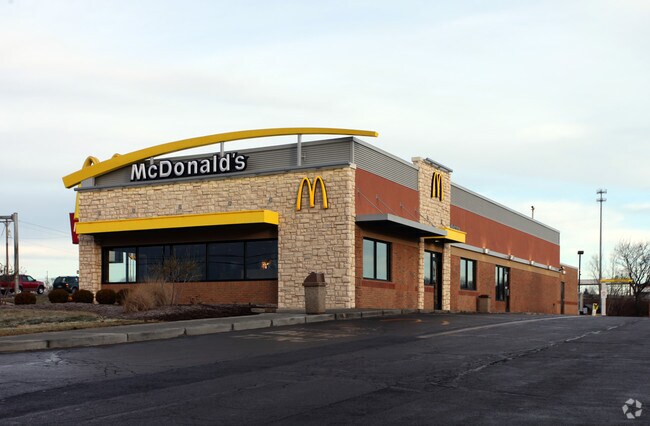
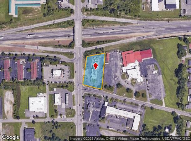
Property Record
540 N Trimble Rd, Mansfield, OH 44906

NEARBY LISTINGS FOR SALE OR LEASE
Property Detail
540 N Trimble Rd
027-04-222-15-000
15149 W PT 280.34 X 177.02 X 540 N TRIMBLE RD
Restaurantbuilding
Richland
X
Ohio
39139C0143E
1.27 AC
2024
Richland County
2024
Cleveland
000700
Mansfield, OH
5,218 SF
DEMOGRAPHICS near 540 N Trimble Rd
1 Mile
3 Mile
5 Mile
2024 Total Population
5,197
41,346
71,134
2029 Population
5,305
41,829
71,632
Pop Growth 2024-2029
+ 2.08%
+ 1.17%
+ 0.70%
Average Age
41
40
41
2024 Total Households
2,329
16,108
28,915
HH Growth 2024-2029
+ 2.02%
+ 1.25%
+ 0.72%
Median Household Inc
$33,231
$36,714
$41,749
Avg Household Size
2.10
2.20
2.20
2024 Avg HH Vehicles
2.00
2.00
2.00
Median Home Value
$60,639
$89,251
$117,335
Median Year Built
1962
1955
1960
Nearby Places
Map Layers
Map Styles
 Street
 Aerial
- Restaurants
- Banks
- Shops
- Fitness
- Groceries
Nearby Properties
Address
Land Use
TOTAL SIZE
Lot Size
Zoning
Address
Land Use
TOTAL SIZE
Lot Size
Zoning
456.50 AC
Address
Land Use
TOTAL SIZE
Lot Size
Zoning
492,672 SF
6.83 AC
Address
Land Use
TOTAL SIZE
Lot Size
Zoning
6,400 SF
137.67 AC
Address
Land Use
TOTAL SIZE
Lot Size
Zoning
354,710 SF
7.07 AC
Address
Land Use
TOTAL SIZE
Lot Size
Zoning
139,809 SF
0.99 AC
Address
Land Use
TOTAL SIZE
Lot Size
Zoning
172,938 SF
16.05 AC
Address
Land Use
TOTAL SIZE
Lot Size
Zoning
136,951 SF
35.76 AC
Address
Land Use
TOTAL SIZE
Lot Size
Zoning
0.06 AC
Address
Land Use
TOTAL SIZE
Lot Size
Zoning
148,135 SF
6.89 AC
Address
Land Use
TOTAL SIZE
Lot Size
Zoning
263,840 SF
16 AC
Address
Land Use
TOTAL SIZE
Lot Size
Zoning
2.31 AC
Address
Land Use
TOTAL SIZE
Lot Size
Zoning
221,864 SF
20 AC
Address
Land Use
TOTAL SIZE
Lot Size
Zoning
36,708 SF
12.56 AC
Address
Land Use
TOTAL SIZE
Lot Size
Zoning
318,366 SF
26.16 AC
Address
Land Use
TOTAL SIZE
Lot Size
Zoning
204,882 SF
32.98 AC
Address
Land Use
TOTAL SIZE
Lot Size
Zoning
458,316 SF
27.90 AC
Address
Land Use
TOTAL SIZE
Lot Size
Zoning
217,680 SF
22.86 AC
Address
Land Use
TOTAL SIZE
Lot Size
Zoning
131,816 SF
17.69 AC
Address
Land Use
TOTAL SIZE
Lot Size
Zoning
32,728 SF
56.23 AC
Address
Land Use
TOTAL SIZE
Lot Size
Zoning
48,602 SF
14.66 AC
Address
Land Use
TOTAL SIZE
Lot Size
Zoning
66,940 SF
12.40 AC
Address
Land Use
TOTAL SIZE
Lot Size
Zoning
1.69 AC
Address
Land Use
TOTAL SIZE
Lot Size
Zoning
125,778 SF
11.63 AC
Address
Land Use
TOTAL SIZE
Lot Size
Zoning
27,501 SF
16.40 AC
Address
Land Use
TOTAL SIZE
Lot Size
Zoning
134,984 SF
17.98 AC
Address
Land Use
TOTAL SIZE
Lot Size
Zoning
179,262 SF
22.54 AC
Address
Land Use
TOTAL SIZE
Lot Size
Zoning
161,800 SF
15.87 AC
Address
Land Use
TOTAL SIZE
Lot Size
Zoning
47.90 AC
Address
Land Use
TOTAL SIZE
Lot Size
Zoning
44,718 SF
0.47 AC
Address
Land Use
TOTAL SIZE
Lot Size
Zoning
26,616 SF
1.10 AC
The World's #1 Commercial Real Estate Marketplace
Connect with us
© 2026 CoStar Group
The information above has been obtained from sources believed reliable. While we do not doubt its accuracy we have not verified it and make no guarantee, warranty or representation about it. It is your responsibility to independently confirm its accuracy and completeness. Any projections, opinions, assumptions, or estimates used are for example only and do not represent the current or future performance of the property. The value of this transaction to you depends on tax and other factors which should be evaluated by your tax, financial, and legal advisors. You and your advisors should conduct a careful, independent investigation of the property to determine to your satisfaction the suitability of the property for your needs.