Property Record
540 Route 47 S, Cape May, NJ 08204


NEARBY LISTINGS FOR SALE OR LEASE
-
-
View all Cape May listings for sale on LoopNet.com
Property Detail
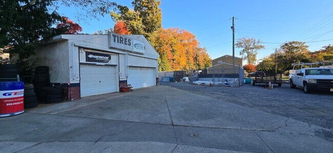
540 Route 47 S
06-01410-01-00028
Cape May
Storebuilding
New Jersey
X
28
34009C0217F
0.69 AC
2024
South Shore/Vineland
2025
Other Market Areas
022101
Ocean City, NJ
DEMOGRAPHICS near 540 Route 47 S
1 Mile
3 Mile
5 Mile
2024 Total Population
478
11,286
22,798
2029 Population
379
9,380
19,515
Pop Growth 2024-2029
(20.71%)
(16.89%)
(14.40%)
Average Age
39
42
44
2024 Total Households
164
4,286
8,870
HH Growth 2024-2029
(25.00%)
(19.67%)
(16.84%)
Median Household Inc
$80,803
$70,833
$73,489
Avg Household Size
2.50
2.40
2.30
2024 Avg HH Vehicles
2.00
2.00
2.00
Median Home Value
$214,167
$238,671
$254,996
Median Year Built
1969
1976
1977
Nearby Places
Map Layers
Map Styles
 Street
 Aerial
- Restaurants
- Banks
- Shops
- Fitness
- Groceries
PUBLIC TRANSPORTATION
AIRPORT
Atlantic City International
DRIVE
WALK
Distance
Atlantic City International
74 min
44.0 mi
Freight Ports
Port of Wilmington, RI
DRIVE
WALK
Distance
Port of Wilmington, RI
103 min
74.3 mi
SALE & LEASE HISTORY
LISTING DATE
SALE/LEASE

Oct 15, 2024
For Sale
Jun 25, 2025
For Sale
Nearby Properties
Address
Land Use
TOTAL SIZE
Lot Size
Zoning
Address
Land Use
TOTAL SIZE
Lot Size
Zoning
32.39 AC
TC
Address
Land Use
TOTAL SIZE
Lot Size
Zoning
1,316 SF
16.41 AC
TR
Address
Land Use
TOTAL SIZE
Lot Size
Zoning
19.18 AC
TC
Address
Land Use
TOTAL SIZE
Lot Size
Zoning
12.73 AC
TC
Address
Land Use
TOTAL SIZE
Lot Size
Zoning
17.56 AC
TC
Address
Land Use
TOTAL SIZE
Lot Size
Zoning
5.67 AC
TC
Address
Land Use
TOTAL SIZE
Lot Size
Zoning
3.71 AC
TC
Address
Land Use
TOTAL SIZE
Lot Size
Zoning
15.25 AC
TC
Address
Land Use
TOTAL SIZE
Lot Size
Zoning
73.03 AC
R-3
Address
Land Use
TOTAL SIZE
Lot Size
Zoning
5.71 AC
TB
Address
Land Use
TOTAL SIZE
Lot Size
Zoning
4.17 AC
TC
Address
Land Use
TOTAL SIZE
Lot Size
Zoning
5.94 AC
TC
Address
Land Use
TOTAL SIZE
Lot Size
Zoning
Address
Land Use
TOTAL SIZE
Lot Size
Zoning
4.99 AC
TC
Address
Land Use
TOTAL SIZE
Lot Size
Zoning
43.80 AC
TRRC
Address
Land Use
TOTAL SIZE
Lot Size
Zoning
5.90 AC
TB
Address
Land Use
TOTAL SIZE
Lot Size
Zoning
1.66 AC
TC
Address
Land Use
TOTAL SIZE
Lot Size
Zoning
68.95 AC
VCRC
Address
Land Use
TOTAL SIZE
Lot Size
Zoning
800 SF
19.09 AC
R-3
Address
Land Use
TOTAL SIZE
Lot Size
Zoning
15.90 AC
TC
Address
Land Use
TOTAL SIZE
Lot Size
Zoning
1,560 SF
83.82 AC
BRC
Address
Land Use
TOTAL SIZE
Lot Size
Zoning
26.87 AC
Address
Land Use
TOTAL SIZE
Lot Size
Zoning
15.25 AC
TC
Address
Land Use
TOTAL SIZE
Lot Size
Zoning
2.71 AC
TC
Address
Land Use
TOTAL SIZE
Lot Size
Zoning
3.51 AC
TB
Address
Land Use
TOTAL SIZE
Lot Size
Zoning
3.67 AC
TC
Address
Land Use
TOTAL SIZE
Lot Size
Zoning
1,794 SF
13.55 AC
TC
Address
Land Use
TOTAL SIZE
Lot Size
Zoning
121.59 AC
RC
Address
Land Use
TOTAL SIZE
Lot Size
Zoning
6.54 AC
TC
Address
Land Use
TOTAL SIZE
Lot Size
Zoning
816 SF
2.06 AC
GB
The World's #1 Commercial Real Estate Marketplace
Connect with us
© 2026 CoStar Group
The information above has been obtained from sources believed reliable. While we do not doubt its accuracy we have not verified it and make no guarantee, warranty or representation about it. It is your responsibility to independently confirm its accuracy and completeness. Any projections, opinions, assumptions, or estimates used are for example only and do not represent the current or future performance of the property. The value of this transaction to you depends on tax and other factors which should be evaluated by your tax, financial, and legal advisors. You and your advisors should conduct a careful, independent investigation of the property to determine to your satisfaction the suitability of the property for your needs.