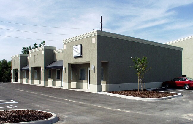
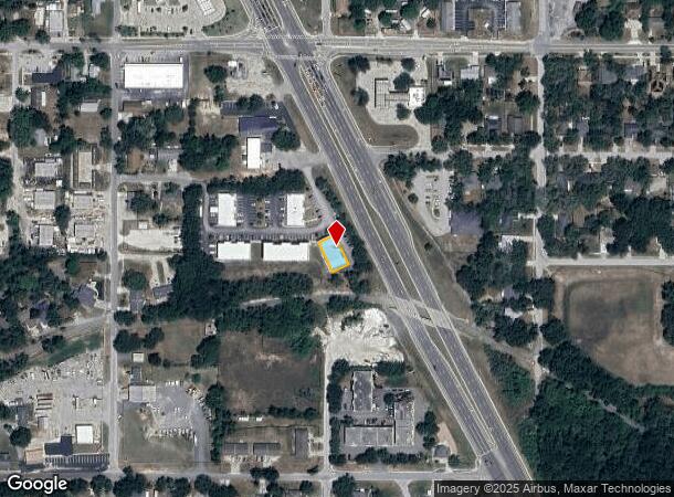
Property Record
540 S Highway 27, Minneola, FL 34715
NEARBY LISTINGS FOR SALE OR LEASE
Property Detail
540 S Highway 27
Orlando-Kissimmee-Sanford, FL
Minneola Replat
18-22-26-0510-19B-00003
MINNEOLA REPLAT FROM NW COR OF LOT 8 BLK 19B RUN S 01-21-0 E 80 FT N 88-40-49 E 403.12 FT S 01-19-11 E 159.70 FT FOR POB RUN N 62-07-02 E 50 FT S 27-52-58 E 100 FT S 62-07-02 W 50 FT N 27-52-58 W 100 FT TO POB TOGETHER WITH 6 FT STRIP ON E SIDE ADJAC
Stripcommercialcenter
Lake
X
Florida
12095C0200H
8
2024
0.13 AC
2026
Lake County
031309
Orlando
5,151 SF
DEMOGRAPHICS near 540 S Highway 27
1 Mile
3 Mile
5 Mile
2024 Total Population
7,086
43,425
93,491
2029 Population
8,232
50,832
109,632
Pop Growth 2024-2029
+ 16.17%
+ 17.06%
+ 17.26%
Average Age
38
40
41
2024 Total Households
2,536
15,722
34,304
HH Growth 2024-2029
+ 15.73%
+ 16.75%
+ 17.04%
Median Household Inc
$78,108
$80,568
$81,973
Avg Household Size
2.80
2.70
2.70
2024 Avg HH Vehicles
2.00
2.00
2.00
Median Home Value
$316,381
$317,723
$322,732
Median Year Built
2001
2002
2004
Nearby Places
- Restaurants
- Banks
- Shops
- Fitness
- Groceries
PUBLIC TRANSPORTATION
AIRPORT
Orlando International
DRIVE
WALK
Distance
Orlando International
47 min
34.4 mi
Freight Ports
Port of Tampa Bay
DRIVE
WALK
Distance
Port of Tampa Bay
101 min
76.7 mi
SALE & LEASE HISTORY
LISTING DATE
SALE/LEASE

Dec 26, 2023
For Lease
Nearby Properties
Address
Land Use
TOTAL SIZE
Lot Size
Zoning
Address
Land Use
TOTAL SIZE
Lot Size
Zoning
403,970 SF
30.99 AC
PUD
Address
Land Use
TOTAL SIZE
Lot Size
Zoning
337,218 SF
16.38 AC
Address
Land Use
TOTAL SIZE
Lot Size
Zoning
285,581 SF
19.34 AC
CFD
Address
Land Use
TOTAL SIZE
Lot Size
Zoning
2,000 SF
35.96 AC
PUD
Address
Land Use
TOTAL SIZE
Lot Size
Zoning
269,594 SF
25.23 AC
PUD
Address
Land Use
TOTAL SIZE
Lot Size
Zoning
179,290 SF
23.79 AC
Address
Land Use
TOTAL SIZE
Lot Size
Zoning
212,649 SF
4.20 AC
Address
Land Use
TOTAL SIZE
Lot Size
Zoning
2,000 SF
26.79 AC
PUD
Address
Land Use
TOTAL SIZE
Lot Size
Zoning
Address
Land Use
TOTAL SIZE
Lot Size
Zoning
52,986 SF
18.27 AC
Address
Land Use
TOTAL SIZE
Lot Size
Zoning
2,000 SF
30.62 AC
CFD
Address
Land Use
TOTAL SIZE
Lot Size
Zoning
2,000 SF
63.78 AC
Address
Land Use
TOTAL SIZE
Lot Size
Zoning
124,634 SF
18.57 AC
Address
Land Use
TOTAL SIZE
Lot Size
Zoning
142,824 SF
9.90 AC
C2
Address
Land Use
TOTAL SIZE
Lot Size
Zoning
126,067 SF
9.34 AC
Address
Land Use
TOTAL SIZE
Lot Size
Zoning
62,794 SF
2.31 AC
Address
Land Use
TOTAL SIZE
Lot Size
Zoning
203,762 SF
18.28 AC
R1
Address
Land Use
TOTAL SIZE
Lot Size
Zoning
95,182 SF
12.34 AC
PUD
Address
Land Use
TOTAL SIZE
Lot Size
Zoning
158,351 SF
19.10 AC
C2
Address
Land Use
TOTAL SIZE
Lot Size
Zoning
87,951 SF
5.88 AC
Address
Land Use
TOTAL SIZE
Lot Size
Zoning
80,774 SF
6.61 AC
Address
Land Use
TOTAL SIZE
Lot Size
Zoning
128,174 SF
9.88 AC
B1
Address
Land Use
TOTAL SIZE
Lot Size
Zoning
80,546 SF
6.75 AC
B1
Address
Land Use
TOTAL SIZE
Lot Size
Zoning
62,415 SF
10.19 AC
Address
Land Use
TOTAL SIZE
Lot Size
Zoning
74,375 SF
6.69 AC
Address
Land Use
TOTAL SIZE
Lot Size
Zoning
90,469 SF
5.99 AC
PUD
Address
Land Use
TOTAL SIZE
Lot Size
Zoning
61,515 SF
9.92 AC
R6
Address
Land Use
TOTAL SIZE
Lot Size
Zoning
99,348 SF
34.10 AC
R1A
Address
Land Use
TOTAL SIZE
Lot Size
Zoning
51,196 SF
2.22 AC
C2
Address
Land Use
TOTAL SIZE
Lot Size
Zoning
72,336 SF
13.62 AC
C2
The World's #1 Commercial Real Estate Marketplace
Connect with us
© 2025 CoStar Group
The information above has been obtained from sources believed reliable. While we do not doubt its accuracy we have not verified it and make no guarantee, warranty or representation about it. It is your responsibility to independently confirm its accuracy and completeness. Any projections, opinions, assumptions, or estimates used are for example only and do not represent the current or future performance of the property. The value of this transaction to you depends on tax and other factors which should be evaluated by your tax, financial, and legal advisors. You and your advisors should conduct a careful, independent investigation of the property to determine to your satisfaction the suitability of the property for your needs.