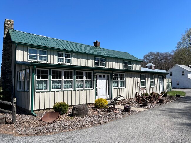
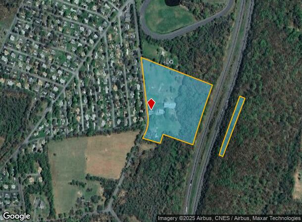
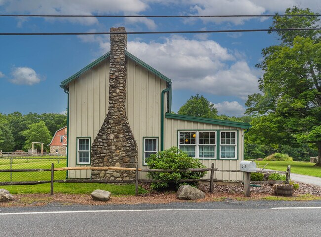
Property Record
540 S Ohioville Rd, New Paltz, NY 12561
NEARBY LISTINGS FOR SALE OR LEASE
Property Detail
540 S Ohioville Rd
514200 94.4-5-17
Ulster
Multifamilydwelling
New York
X
17.000
36111C0765E
13.80 AC
2025
Newburgh/Kingston
2024
Other Market Areas
954000
Kingston, NY
2,172 SF
DEMOGRAPHICS near 540 S Ohioville Rd
1 Mile
3 Mile
5 Mile
2024 Total Population
1,376
7,705
26,042
2029 Population
1,356
7,628
25,855
Pop Growth 2024-2029
(1.45%)
(1.00%)
(0.72%)
Average Age
49
43
40
2024 Total Households
626
3,013
9,274
HH Growth 2024-2029
(1.44%)
(1.13%)
(0.95%)
Median Household Inc
$67,232
$90,763
$86,549
Avg Household Size
2.20
2.40
2.40
2024 Avg HH Vehicles
2.00
2.00
2.00
Median Home Value
$191,666
$318,350
$336,842
Median Year Built
1986
1980
1976
Nearby Places
Map Layers
Map Styles
 Street
 Aerial
- Restaurants
- Banks
- Shops
- Fitness
- Groceries
PUBLIC TRANSPORTATION
AIRPORT
New York Stewart International
DRIVE
WALK
Distance
New York Stewart International
34 min
17.5 mi
Freight Ports
Port of New Haven
DRIVE
WALK
Distance
Port of New Haven
124 min
88.7 mi
SALE & LEASE HISTORY
LISTING DATE
SALE/LEASE

Jun 22, 2023
For Sale
Nearby Properties
Address
Land Use
TOTAL SIZE
Lot Size
Zoning
Address
Land Use
TOTAL SIZE
Lot Size
Zoning
31.40 AC
R1
Address
Land Use
TOTAL SIZE
Lot Size
Zoning
94,258 SF
55 AC
I1
Address
Land Use
TOTAL SIZE
Lot Size
Zoning
34,640 SF
12.40 AC
BD40
Address
Land Use
TOTAL SIZE
Lot Size
Zoning
8,155 SF
4.90 AC
R1
Address
Land Use
TOTAL SIZE
Lot Size
Zoning
84,742 SF
6.50 AC
A15
Address
Land Use
TOTAL SIZE
Lot Size
Zoning
1,456 SF
46 AC
HR-1
Address
Land Use
TOTAL SIZE
Lot Size
Zoning
Address
Land Use
TOTAL SIZE
Lot Size
Zoning
5,296 SF
112.20 AC
R1
Address
Land Use
TOTAL SIZE
Lot Size
Zoning
3,360 SF
10.31 AC
BD60
Address
Land Use
TOTAL SIZE
Lot Size
Zoning
780 SF
67.90 AC
BD40
Address
Land Use
TOTAL SIZE
Lot Size
Zoning
2,448 SF
141.50 AC
BD60/AG1.5
Address
Land Use
TOTAL SIZE
Lot Size
Zoning
4,866 SF
6.90 AC
RA
Address
Land Use
TOTAL SIZE
Lot Size
Zoning
7,039 SF
31.90 AC
AG1.5
Address
Land Use
TOTAL SIZE
Lot Size
Zoning
980 SF
11.80 AC
HR-1
Address
Land Use
TOTAL SIZE
Lot Size
Zoning
2,750 SF
12.10 AC
RA
Address
Land Use
TOTAL SIZE
Lot Size
Zoning
13,020 SF
1.40 AC
HC
Address
Land Use
TOTAL SIZE
Lot Size
Zoning
9,100 SF
2.30 AC
BD40
Address
Land Use
TOTAL SIZE
Lot Size
Zoning
3,340 SF
5.48 AC
RA
Address
Land Use
TOTAL SIZE
Lot Size
Zoning
3,379 SF
194.80 AC
RR1.5
Address
Land Use
TOTAL SIZE
Lot Size
Zoning
4,393 SF
19.70 AC
RA
Address
Land Use
TOTAL SIZE
Lot Size
Zoning
1,950 SF
0.90 AC
BD40
Address
Land Use
TOTAL SIZE
Lot Size
Zoning
5,938 SF
0.30 AC
BD40
Address
Land Use
TOTAL SIZE
Lot Size
Zoning
9,900 SF
1.30 AC
BD40
Address
Land Use
TOTAL SIZE
Lot Size
Zoning
720 SF
8.10 AC
HR 1
Address
Land Use
TOTAL SIZE
Lot Size
Zoning
2,080 SF
63.90 AC
BD60
Address
Land Use
TOTAL SIZE
Lot Size
Zoning
9,570 SF
5 AC
RR1.5
Address
Land Use
TOTAL SIZE
Lot Size
Zoning
38,970 SF
26.50 AC
RR1.5
Address
Land Use
TOTAL SIZE
Lot Size
Zoning
5,618 SF
12.30 AC
RR1.5
Address
Land Use
TOTAL SIZE
Lot Size
Zoning
3,428 SF
2.50 AC
RA
Address
Land Use
TOTAL SIZE
Lot Size
Zoning
5,320 SF
10.44 AC
CLI
The World's #1 Commercial Real Estate Marketplace
Connect with us
© 2025 CoStar Group
The information above has been obtained from sources believed reliable. While we do not doubt its accuracy we have not verified it and make no guarantee, warranty or representation about it. It is your responsibility to independently confirm its accuracy and completeness. Any projections, opinions, assumptions, or estimates used are for example only and do not represent the current or future performance of the property. The value of this transaction to you depends on tax and other factors which should be evaluated by your tax, financial, and legal advisors. You and your advisors should conduct a careful, independent investigation of the property to determine to your satisfaction the suitability of the property for your needs.