Property Record
5400 Bristol Emilie Rd, Levittown, PA 19057
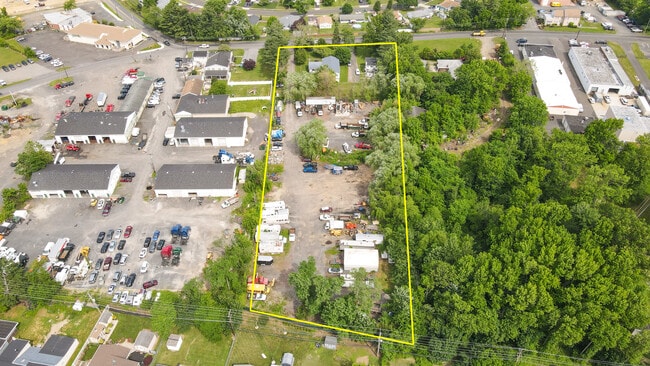
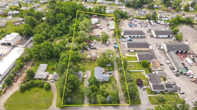
This Property Is For Sale
NEARBY LISTINGS FOR SALE OR LEASE
Property Detail
5400 Bristol Emilie Rd
Philadelphia-Camden-Wilmington, PA-NJ-DE-MD
Emilie Rd Plan
05-032-416-005
1.8699AC 5400 EMILIE RD PLAN LOT #3 NO FRONTAGE
Commercialnec
Bucks
X
Pennsylvania
42017C0463K
3
2024
1.87 AC
2025
Lower Bucks County
100402
Philadelphia
DEMOGRAPHICS near 5400 Bristol Emilie Rd
1 Mile
3 Mile
5 Mile
2024 Total Population
14,508
103,294
209,578
2029 Population
14,421
102,755
209,280
Pop Growth 2024-2029
(0.60%)
(0.52%)
(0.14%)
Average Age
41
41
42
2024 Total Households
5,325
38,776
79,389
HH Growth 2024-2029
(0.68%)
(0.56%)
(0.17%)
Median Household Inc
$87,056
$84,451
$86,942
Avg Household Size
2.60
2.60
2.50
2024 Avg HH Vehicles
2.00
2.00
2.00
Median Home Value
$250,442
$267,190
$284,424
Median Year Built
1956
1958
1965
Nearby Places
- Restaurants
- Banks
- Shops
- Fitness
- Groceries
PUBLIC TRANSPORTATION
COMMUTER RAIL
Bristol (R7 - Southeastern Pennsylvania Transportation Authority Regional Rail (SEPTA Regional Rail))
DRIVE
WALK
Distance
Bristol (R7 - Southeastern Pennsylvania Transportation Authority Regional Rail (SEPTA Regional Rail))
8 min
3.1 mi
Levittown (R7 - Southeastern Pennsylvania Transportation Authority Regional Rail (SEPTA Regional Rail))
DRIVE
WALK
Distance
Levittown (R7 - Southeastern Pennsylvania Transportation Authority Regional Rail (SEPTA Regional Rail))
9 min
4.3 mi
AIRPORT
Trenton Mercer
DRIVE
WALK
Distance
Trenton Mercer
24 min
13.3 mi
Philadelphia International
DRIVE
WALK
Distance
Philadelphia International
50 min
32.4 mi
Freight Ports
Port of Philadelphia
DRIVE
WALK
Distance
Port of Philadelphia
30 min
18.7 mi
Nearby Properties
Address
Land Use
TOTAL SIZE
Lot Size
Zoning
Address
Land Use
TOTAL SIZE
Lot Size
Zoning
486,812 SF
44.42 AC
Address
Land Use
TOTAL SIZE
Lot Size
Zoning
Address
Land Use
TOTAL SIZE
Lot Size
Zoning
Address
Land Use
TOTAL SIZE
Lot Size
Zoning
32.60 AC
Address
Land Use
TOTAL SIZE
Lot Size
Zoning
32,912 SF
42.06 AC
AO
Address
Land Use
TOTAL SIZE
Lot Size
Zoning
5.44 AC
Address
Land Use
TOTAL SIZE
Lot Size
Zoning
25.24 AC
Address
Land Use
TOTAL SIZE
Lot Size
Zoning
11,280 SF
26.16 AC
R3
Address
Land Use
TOTAL SIZE
Lot Size
Zoning
50.71 AC
Address
Land Use
TOTAL SIZE
Lot Size
Zoning
4.02 AC
Address
Land Use
TOTAL SIZE
Lot Size
Zoning
150,000 SF
21.46 AC
R3
Address
Land Use
TOTAL SIZE
Lot Size
Zoning
528,000 SF
74.88 AC
Address
Land Use
TOTAL SIZE
Lot Size
Zoning
19.95 AC
CD
Address
Land Use
TOTAL SIZE
Lot Size
Zoning
163,209 SF
23.23 AC
HC
Address
Land Use
TOTAL SIZE
Lot Size
Zoning
202,400 SF
20.98 AC
C
Address
Land Use
TOTAL SIZE
Lot Size
Zoning
242,550 SF
24.32 AC
PI
Address
Land Use
TOTAL SIZE
Lot Size
Zoning
132,780 SF
11.09 AC
R3
Address
Land Use
TOTAL SIZE
Lot Size
Zoning
242,550 SF
24.18 AC
PI
Address
Land Use
TOTAL SIZE
Lot Size
Zoning
125,307 SF
31.79 AC
VC
Address
Land Use
TOTAL SIZE
Lot Size
Zoning
171,918 SF
17.70 AC
AO
Address
Land Use
TOTAL SIZE
Lot Size
Zoning
60,000 SF
19.99 AC
I
Address
Land Use
TOTAL SIZE
Lot Size
Zoning
148,444 SF
24.06 AC
HR
Address
Land Use
TOTAL SIZE
Lot Size
Zoning
10,812 SF
16.87 AC
R3
Address
Land Use
TOTAL SIZE
Lot Size
Zoning
281,600 SF
26.57 AC
PI
Address
Land Use
TOTAL SIZE
Lot Size
Zoning
163,779 SF
20.10 AC
MI
Address
Land Use
TOTAL SIZE
Lot Size
Zoning
188,931 SF
15.99 AC
HC
Address
Land Use
TOTAL SIZE
Lot Size
Zoning
9.54 AC
M2
Address
Land Use
TOTAL SIZE
Lot Size
Zoning
37,146 SF
11.50 AC
M2
Address
Land Use
TOTAL SIZE
Lot Size
Zoning
146,556 SF
30.35 AC
C
Address
Land Use
TOTAL SIZE
Lot Size
Zoning
99,124 SF
10.14 AC
C
The World's #1 Commercial Real Estate Marketplace
Connect with us
© 2025 CoStar Group
The information above has been obtained from sources believed reliable. While we do not doubt its accuracy we have not verified it and make no guarantee, warranty or representation about it. It is your responsibility to independently confirm its accuracy and completeness. Any projections, opinions, assumptions, or estimates used are for example only and do not represent the current or future performance of the property. The value of this transaction to you depends on tax and other factors which should be evaluated by your tax, financial, and legal advisors. You and your advisors should conduct a careful, independent investigation of the property to determine to your satisfaction the suitability of the property for your needs.