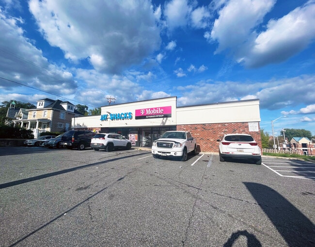
Property Record
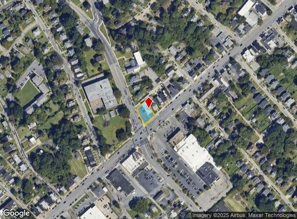
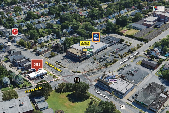
5400 Belair Rd, Baltimore, MD 21206
This Property Is For Sale
NEARBY LISTINGS FOR SALE OR LEASE
Property Detail
5400 Belair Rd
5818-001
0.216 ACRES
Storebuilding
Baltimore City
X
Maryland
2400100410G
1
2024
0.22 AC
2025
Baltimore Northeast
270401
Baltimore
2,620 SF
Baltimore-Columbia-Towson, MD
DEMOGRAPHICS near 5400 Belair Rd
1 Mile
3 Mile
5 Mile
2024 Total Population
21,690
168,728
483,471
2029 Population
20,319
161,856
468,278
Pop Growth 2024-2029
(6.32%)
(4.07%)
(3.14%)
Average Age
40
40
39
2024 Total Households
8,650
67,575
204,287
HH Growth 2024-2029
(6.45%)
(4.31%)
(3.38%)
Median Household Inc
$65,870
$59,062
$64,975
Avg Household Size
2.40
2.40
2.20
2024 Avg HH Vehicles
2.00
1.00
1.00
Median Home Value
$180,737
$183,216
$233,138
Median Year Built
1950
1952
1953
Nearby Places
- Restaurants
- Banks
- Shops
- Fitness
- Groceries
PUBLIC TRANSPORTATION
COMMUTER RAIL
Penn Station (PENN - WASHINGTON - Maryland Area Regional Commuter Trains (The MARC), Penn Line - Maryland Area Regional Commuter Trains (The MARC), Penn Station & Camden Yards - Maryland Area Regional Commuter Trains (The MARC))
DRIVE
WALK
Distance
Penn Station (PENN - WASHINGTON - Maryland Area Regional Commuter Trains (The MARC), Penn Line - Maryland Area Regional Commuter Trains (The MARC), Penn Station & Camden Yards - Maryland Area Regional Commuter Trains (The MARC))
12 min
4.6 mi
Camden Station (CAMDEN - WASHINGTON - Maryland Area Regional Commuter Trains (The MARC), Camden Line - Maryland Area Regional Commuter Trains (The MARC))
DRIVE
WALK
Distance
Camden Station (CAMDEN - WASHINGTON - Maryland Area Regional Commuter Trains (The MARC), Camden Line - Maryland Area Regional Commuter Trains (The MARC))
17 min
5.9 mi
AIRPORT
Baltimore/Washington International Thurgood Marshall
DRIVE
WALK
Distance
Baltimore/Washington International Thurgood Marshall
31 min
17.9 mi
Freight Ports
Port of Baltimore
DRIVE
WALK
Distance
Port of Baltimore
19 min
9.6 mi
Nearby Properties
Address
Land Use
TOTAL SIZE
Lot Size
Zoning
Address
Land Use
TOTAL SIZE
Lot Size
Zoning
21,312 SF
54.36 AC
EC-2
Address
Land Use
TOTAL SIZE
Lot Size
Zoning
24,993 SF
66.85 AC
EC-2
Address
Land Use
TOTAL SIZE
Lot Size
Zoning
316,273 SF
25.90 AC
H
Address
Land Use
TOTAL SIZE
Lot Size
Zoning
140,000 SF
9.11 AC
EC-2
Address
Land Use
TOTAL SIZE
Lot Size
Zoning
303,115 SF
7.62 AC
R-3
Address
Land Use
TOTAL SIZE
Lot Size
Zoning
3.01 AC
EC-2
Address
Land Use
TOTAL SIZE
Lot Size
Zoning
0.01 AC
R-3
Address
Land Use
TOTAL SIZE
Lot Size
Zoning
287,500 SF
44 SF
R-5
Address
Land Use
TOTAL SIZE
Lot Size
Zoning
621,041 SF
32.69 AC
MH-IM
Address
Land Use
TOTAL SIZE
Lot Size
Zoning
7,718 SF
152.79 AC
OS
Address
Land Use
TOTAL SIZE
Lot Size
Zoning
41,184 SF
93.14 AC
EC-1
Address
Land Use
TOTAL SIZE
Lot Size
Zoning
310,390 SF
34.21 AC
R-6
Address
Land Use
TOTAL SIZE
Lot Size
Zoning
241,842 SF
3.49 AC
EC-2
Address
Land Use
TOTAL SIZE
Lot Size
Zoning
51,755 SF
262.59 AC
OS
Address
Land Use
TOTAL SIZE
Lot Size
Zoning
227,772 SF
19.14 AC
2-1
Address
Land Use
TOTAL SIZE
Lot Size
Zoning
134,476 SF
16.54 AC
R-6
Address
Land Use
TOTAL SIZE
Lot Size
Zoning
470,769 SF
441.11 AC
OS
Address
Land Use
TOTAL SIZE
Lot Size
Zoning
130,138 SF
3.27 AC
R-6
Address
Land Use
TOTAL SIZE
Lot Size
Zoning
11.38 AC
Address
Land Use
TOTAL SIZE
Lot Size
Zoning
105,384 SF
15.41 AC
Address
Land Use
TOTAL SIZE
Lot Size
Zoning
18 AC
EC-2
Address
Land Use
TOTAL SIZE
Lot Size
Zoning
14.10 AC
DR16
Address
Land Use
TOTAL SIZE
Lot Size
Zoning
111,000 SF
29.85 AC
BM
Address
Land Use
TOTAL SIZE
Lot Size
Zoning
213,272 SF
16.25 AC
R-5
Address
Land Use
TOTAL SIZE
Lot Size
Zoning
14.23 AC
R-5
Address
Land Use
TOTAL SIZE
Lot Size
Zoning
211,432 SF
36.36 AC
I-2
Address
Land Use
TOTAL SIZE
Lot Size
Zoning
100,092 SF
8.80 AC
C-3
Address
Land Use
TOTAL SIZE
Lot Size
Zoning
163,386 SF
26.71 AC
DR5.5
Address
Land Use
TOTAL SIZE
Lot Size
Zoning
367,349 SF
15.67 AC
R-3
Address
Land Use
TOTAL SIZE
Lot Size
Zoning
11.79 AC
R-5
The World's #1 Commercial Real Estate Marketplace
Connect with us
© 2025 CoStar Group
The information above has been obtained from sources believed reliable. While we do not doubt its accuracy we have not verified it and make no guarantee, warranty or representation about it. It is your responsibility to independently confirm its accuracy and completeness. Any projections, opinions, assumptions, or estimates used are for example only and do not represent the current or future performance of the property. The value of this transaction to you depends on tax and other factors which should be evaluated by your tax, financial, and legal advisors. You and your advisors should conduct a careful, independent investigation of the property to determine to your satisfaction the suitability of the property for your needs.