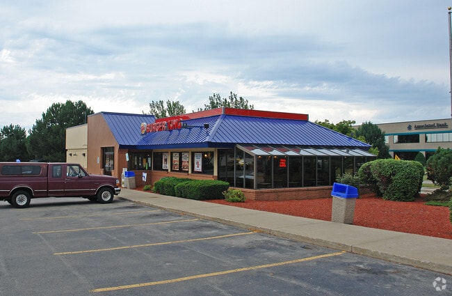
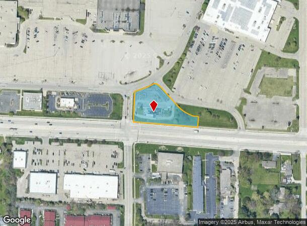
Property Record
5400 Durand Ave, Racine, WI 53406

NEARBY LISTINGS FOR SALE OR LEASE
Property Detail
5400 Durand Ave
Racine, WI
Regency Mall
276-000023876021
BLK 1 REGENCY MALL LOT 6 EXC PT FOR R/W AS DESC IN DOC #2493684
Restaurantdrivein
Racine
X
Wisconsin
55101C0228D
6
2024
1.28 AC
2024
Racine East
000901
Milwaukee/Madison
2,732 SF
DEMOGRAPHICS near 5400 Durand Ave
1 Mile
3 Mile
5 Mile
2024 Total Population
9,744
65,577
119,725
2029 Population
9,653
64,953
118,959
Pop Growth 2024-2029
(0.93%)
(0.95%)
(0.64%)
Average Age
41
40
40
2024 Total Households
4,146
26,738
48,586
HH Growth 2024-2029
(0.92%)
(0.99%)
(0.67%)
Median Household Inc
$49,904
$62,394
$60,037
Avg Household Size
2.20
2.30
2.30
2024 Avg HH Vehicles
2.00
2.00
2.00
Median Home Value
$193,220
$172,417
$182,375
Median Year Built
1972
1963
1963
Nearby Places
Map Layers
Map Styles
 Street
 Aerial
- Restaurants
- Banks
- Shops
- Fitness
- Groceries
PUBLIC TRANSPORTATION
COMMUTER RAIL
Sturtevant Amtrak Station (Hiawatha Service - Amtrak)
DRIVE
WALK
Distance
Sturtevant Amtrak Station (Hiawatha Service - Amtrak)
12 min
6.0 mi
AIRPORT
General Mitchell International
DRIVE
WALK
Distance
General Mitchell International
35 min
24.9 mi
Freight Ports
Port Milwaukee
DRIVE
WALK
Distance
Port Milwaukee
40 min
28.8 mi
SALE & LEASE HISTORY
LISTING DATE
SALE/LEASE

Sep 29, 2016
For Sale
Nov 18, 2016
For Sale
Nearby Properties
Address
Land Use
TOTAL SIZE
Lot Size
Zoning
Address
Land Use
TOTAL SIZE
Lot Size
Zoning
318.64 AC
Address
Land Use
TOTAL SIZE
Lot Size
Zoning
22.34 AC
Address
Land Use
TOTAL SIZE
Lot Size
Zoning
9.40 AC
B-3
Address
Land Use
TOTAL SIZE
Lot Size
Zoning
47.01 AC
M-1
Address
Land Use
TOTAL SIZE
Lot Size
Zoning
61,744 SF
42.23 AC
OI
Address
Land Use
TOTAL SIZE
Lot Size
Zoning
57.80 AC
M1
Address
Land Use
TOTAL SIZE
Lot Size
Zoning
14.11 AC
I2
Address
Land Use
TOTAL SIZE
Lot Size
Zoning
9.31 AC
Address
Land Use
TOTAL SIZE
Lot Size
Zoning
Address
Land Use
TOTAL SIZE
Lot Size
Zoning
22.98 AC
M-1
Address
Land Use
TOTAL SIZE
Lot Size
Zoning
19.77 AC
B-3
Address
Land Use
TOTAL SIZE
Lot Size
Zoning
6.77 AC
PUL
Address
Land Use
TOTAL SIZE
Lot Size
Zoning
15.81 AC
Address
Land Use
TOTAL SIZE
Lot Size
Zoning
24.04 AC
BP
Address
Land Use
TOTAL SIZE
Lot Size
Zoning
0.11 AC
B-3
Address
Land Use
TOTAL SIZE
Lot Size
Zoning
33.40 AC
I2
Address
Land Use
TOTAL SIZE
Lot Size
Zoning
10.02 AC
Address
Land Use
TOTAL SIZE
Lot Size
Zoning
98.81 AC
Address
Land Use
TOTAL SIZE
Lot Size
Zoning
Address
Land Use
TOTAL SIZE
Lot Size
Zoning
164,201 SF
17 AC
B2
Address
Land Use
TOTAL SIZE
Lot Size
Zoning
Address
Land Use
TOTAL SIZE
Lot Size
Zoning
2.10 AC
Address
Land Use
TOTAL SIZE
Lot Size
Zoning
Address
Land Use
TOTAL SIZE
Lot Size
Zoning
76.18 AC
Address
Land Use
TOTAL SIZE
Lot Size
Zoning
22.72 AC
Address
Land Use
TOTAL SIZE
Lot Size
Zoning
58,485 SF
19.71 AC
I2
Address
Land Use
TOTAL SIZE
Lot Size
Zoning
11.70 AC
M-1
Address
Land Use
TOTAL SIZE
Lot Size
Zoning
20.57 AC
Address
Land Use
TOTAL SIZE
Lot Size
Zoning
Address
Land Use
TOTAL SIZE
Lot Size
Zoning
11.56 AC
The World's #1 Commercial Real Estate Marketplace
Connect with us
© 2025 CoStar Group
The information above has been obtained from sources believed reliable. While we do not doubt its accuracy we have not verified it and make no guarantee, warranty or representation about it. It is your responsibility to independently confirm its accuracy and completeness. Any projections, opinions, assumptions, or estimates used are for example only and do not represent the current or future performance of the property. The value of this transaction to you depends on tax and other factors which should be evaluated by your tax, financial, and legal advisors. You and your advisors should conduct a careful, independent investigation of the property to determine to your satisfaction the suitability of the property for your needs.