Property Record
5400 Laurel Springs Pky, Suwanee, GA 30024

NEARBY LISTINGS FOR SALE OR LEASE
Property Detail
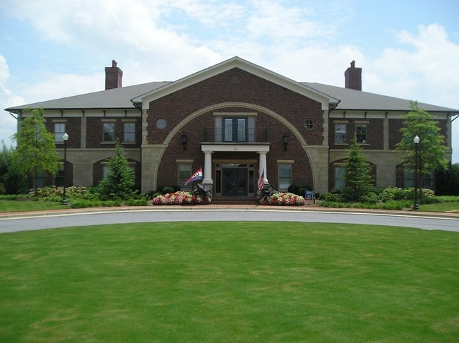
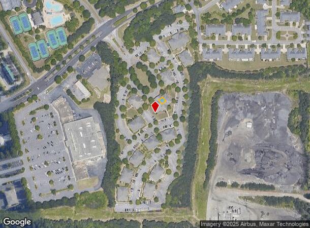
5400 Laurel Springs Pky
138-462
Gates @ Ls
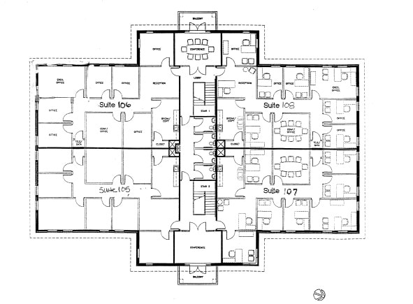
Officecondo
2-1 1155 BLG100-UN103 PH1 GATES @ LS
X
Forsyth
13121C0083F
Georgia
2024
0.18 AC
2025
N Fulton/Forsyth County
130608
Atlanta
2,062 SF
Atlanta-Sandy Springs-Roswell, GA
DEMOGRAPHICS near 5400 Laurel Springs Pky
1 Mile
3 Mile
5 Mile
2024 Total Population
6,378
66,367
180,749
2029 Population
7,345
73,170
196,194
Pop Growth 2024-2029
+ 15.16%
+ 10.25%
+ 8.54%
Average Age
41
39
38
2024 Total Households
2,011
20,743
59,317
HH Growth 2024-2029
+ 15.22%
+ 10.17%
+ 8.60%
Median Household Inc
$151,017
$159,732
$143,515
Avg Household Size
3.10
3.20
3.00
2024 Avg HH Vehicles
2.00
2.00
2.00
Median Home Value
$651,215
$538,212
$478,122
Median Year Built
2002
1998
1999
Nearby Places
Map Layers
Map Styles
 Street
 Aerial
- Restaurants
- Banks
- Shops
- Fitness
- Groceries
SALE & LEASE HISTORY
LISTING DATE
SALE/LEASE

Sep 25, 2016
For Lease
Sep 21, 2021
For Lease
Sep 03, 2019
For Sale
Oct 04, 2017
For Lease
Nov 07, 2016
For Lease
Nov 03, 2016
For Lease
Mar 26, 2020
For Lease
Jun 13, 2019
For Lease
Jun 09, 2021
For Lease
Jul 31, 2019
For Lease
Nearby Properties
Address
Land Use
TOTAL SIZE
Lot Size
Zoning
Address
Land Use
TOTAL SIZE
Lot Size
Zoning
321,541 SF
63.16 AC
OI
Address
Land Use
TOTAL SIZE
Lot Size
Zoning
489,097 SF
34 AC
R3
Address
Land Use
TOTAL SIZE
Lot Size
Zoning
559,910 SF
74.65 AC
Address
Land Use
TOTAL SIZE
Lot Size
Zoning
299,952 SF
23.49 AC
MIAC
Address
Land Use
TOTAL SIZE
Lot Size
Zoning
321,116 SF
17.06 AC
CBD
Address
Land Use
TOTAL SIZE
Lot Size
Zoning
47,721 SF
12.99 AC
CBD
Address
Land Use
TOTAL SIZE
Lot Size
Zoning
244,177 SF
8.96 AC
MIXU
Address
Land Use
TOTAL SIZE
Lot Size
Zoning
214,626 SF
6.29 AC
Address
Land Use
TOTAL SIZE
Lot Size
Zoning
289,676 SF
4.03 AC
C1
Address
Land Use
TOTAL SIZE
Lot Size
Zoning
291,232 SF
71.66 AC
RES3
Address
Land Use
TOTAL SIZE
Lot Size
Zoning
343,180 SF
17.29 AC
OI
Address
Land Use
TOTAL SIZE
Lot Size
Zoning
163,592 SF
17.60 AC
OI
Address
Land Use
TOTAL SIZE
Lot Size
Zoning
133,800 SF
5.20 AC
C1
Address
Land Use
TOTAL SIZE
Lot Size
Zoning
21.36 AC
MIXU
Address
Land Use
TOTAL SIZE
Lot Size
Zoning
91,296 SF
12.76 AC
CBD
Address
Land Use
TOTAL SIZE
Lot Size
Zoning
14,880 SF
16.51 AC
CBD
Address
Land Use
TOTAL SIZE
Lot Size
Zoning
101,510 SF
15.45 AC
CBD
Address
Land Use
TOTAL SIZE
Lot Size
Zoning
102,784 SF
9.16 AC
MIAC
Address
Land Use
TOTAL SIZE
Lot Size
Zoning
45,603 SF
8.36 AC
CBD
Address
Land Use
TOTAL SIZE
Lot Size
Zoning
126,793 SF
10.78 AC
M1
Address
Land Use
TOTAL SIZE
Lot Size
Zoning
117,036 SF
13.62 AC
CBD
Address
Land Use
TOTAL SIZE
Lot Size
Zoning
136,660 SF
21.47 AC
M1
Address
Land Use
TOTAL SIZE
Lot Size
Zoning
169,042 SF
19.36 AC
M1
Address
Land Use
TOTAL SIZE
Lot Size
Zoning
73,022 SF
6.57 AC
CBD
Address
Land Use
TOTAL SIZE
Lot Size
Zoning
73,963 SF
10.57 AC
CBD
Address
Land Use
TOTAL SIZE
Lot Size
Zoning
88,288 SF
7.76 AC
C1
Address
Land Use
TOTAL SIZE
Lot Size
Zoning
126,920 SF
12.25 AC
M1
Address
Land Use
TOTAL SIZE
Lot Size
Zoning
127,096 SF
7.25 AC
M1
Address
Land Use
TOTAL SIZE
Lot Size
Zoning
88,218 SF
13.36 AC
C1
Address
Land Use
TOTAL SIZE
Lot Size
Zoning
99,972 SF
5.61 AC
CBD
The World's #1 Commercial Real Estate Marketplace
Connect with us
© 2025 CoStar Group
The information above has been obtained from sources believed reliable. While we do not doubt its accuracy we have not verified it and make no guarantee, warranty or representation about it. It is your responsibility to independently confirm its accuracy and completeness. Any projections, opinions, assumptions, or estimates used are for example only and do not represent the current or future performance of the property. The value of this transaction to you depends on tax and other factors which should be evaluated by your tax, financial, and legal advisors. You and your advisors should conduct a careful, independent investigation of the property to determine to your satisfaction the suitability of the property for your needs.