Property Record
5400 Old Pearce Rd, Wake Forest, NC 27587

Save to a Folder
{{folder.Name}}
{{folder.ListingIds.length}} Properties
{{folder.ListingIds.length}} Property
Create a New Folder
Property Detail
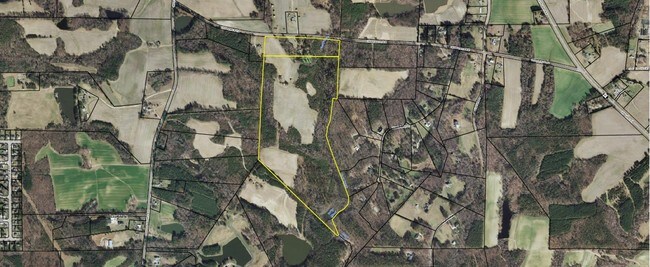
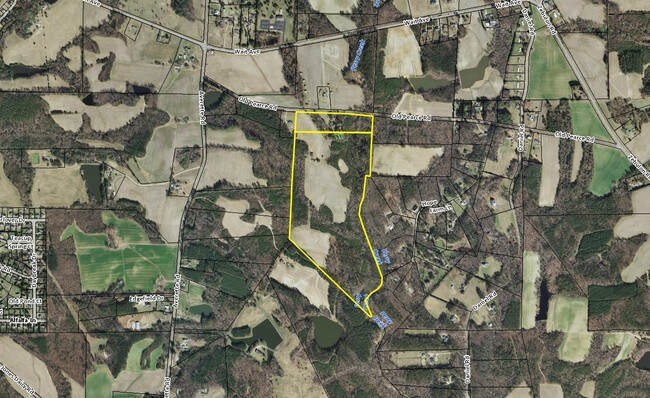
5400 Old Pearce Rd
1860.03-32-7452-000
PEARCE LD
Farms
WAKE
R-40W
North Carolina
AE The base floodplain where base flood elevations are provided. AE Zones are now used on new format FIRMs instead of A1-A30 Zones.
70.06 AC
2025
Route 1
2025
Raleigh/Durham
054221
Raleigh-Cary, NC
NEARBY LISTINGS FOR SALE OR LEASE
DEMOGRAPHICS near 5400 Old Pearce Rd
1 mile
3 mile
5 mile
2025 Total Population
1,359
25,605
74,006
2030 Population
1,528
28,200
81,189
Pop Growth 2025-2030
+ 12.44%
+ 10.13%
+ 9.71%
Average Age
37
39
40
2025 Total Households
434
8,640
26,373
HH Growth 2025-2030
+ 12.90%
+ 10.53%
+ 10.17%
Median Household Inc
$164,182
$152,919
$119,537
Avg Household Size
3.10
3.00
2.80
2025 Avg HH Vehicles
2.00
2.00
2.00
Median Home Value
$445,673
$535,469
$472,279
Median Year Built
2010
2010
2008
Nearby Places
Map Layers
Map Styles
 Street
 Aerial
Layers
 Traffic
 Biking
Places
Listings with unknown addresses are not visible on the map
- Restaurants
- Banks
- Shops
- Fitness
- Groceries
PUBLIC TRANSPORTATION
AIRPORT
Raleigh-Durham International
Drive
Walk
Distance
Raleigh-Durham International
41 min
27.1 mi
Freight Ports
Virginia Port Authority - Richmond
Drive
Walk
Distance
Virginia Port Authority - Richmond
167 min
136.1 mi
SALE & LEASE HISTORY
LISTING DATE
SALE/LEASE

Sep 24, 2016
For Sale
Nearby Properties
Address
Land Use
TOTAL SIZE
Lot Size
Zoning
Address
Land Use
TOTAL SIZE
Lot Size
Zoning
378,421 SF
19.06 AC
RMX
Address
Land Use
TOTAL SIZE
Lot Size
Zoning
227,653 SF
10.84 AC
TC
Address
Land Use
TOTAL SIZE
Lot Size
Zoning
100,625 SF
16.39 AC
RL
Address
Land Use
TOTAL SIZE
Lot Size
Zoning
88,053 SF
12.16 AC
GR10
Address
Land Use
TOTAL SIZE
Lot Size
Zoning
101,307 SF
21 AC
HB
Address
Land Use
TOTAL SIZE
Lot Size
Zoning
58,211 SF
6.96 AC
NMX
Address
Land Use
TOTAL SIZE
Lot Size
Zoning
74,000 SF
20 AC
R-30
Address
Land Use
TOTAL SIZE
Lot Size
Zoning
53,707 SF
17.07 AC
RL
Address
Land Use
TOTAL SIZE
Lot Size
Zoning
75,210 SF
1.78 AC
HB
Address
Land Use
TOTAL SIZE
Lot Size
Zoning
66,801 SF
11.01 AC
RL
Address
Land Use
TOTAL SIZE
Lot Size
Zoning
44,966 SF
7.16 AC
HB
Address
Land Use
TOTAL SIZE
Lot Size
Zoning
58,813 SF
5.46 AC
RMX
Address
Land Use
TOTAL SIZE
Lot Size
Zoning
61,720 SF
7.76 AC
HB
Address
Land Use
TOTAL SIZE
Lot Size
Zoning
36,295 SF
5.71 AC
GC
Address
Land Use
TOTAL SIZE
Lot Size
Zoning
46,203 SF
4.68 AC
GC-CZ
Address
Land Use
TOTAL SIZE
Lot Size
Zoning
65,078 SF
5.74 AC
R&PUD
Address
Land Use
TOTAL SIZE
Lot Size
Zoning
28,670 SF
8.28 AC
GC-CZ
Address
Land Use
TOTAL SIZE
Lot Size
Zoning
47,318 SF
4.67 AC
GR10
Address
Land Use
TOTAL SIZE
Lot Size
Zoning
25,311 SF
2.52 AC
HB
Address
Land Use
TOTAL SIZE
Lot Size
Zoning
32.96 AC
TC
Address
Land Use
TOTAL SIZE
Lot Size
Zoning
21,245 SF
0.45 AC
RL
Address
Land Use
TOTAL SIZE
Lot Size
Zoning
14,652 SF
1.74 AC
GC
Address
Land Use
TOTAL SIZE
Lot Size
Zoning
81,031 SF
6.13 AC
R&PUD
Address
Land Use
TOTAL SIZE
Lot Size
Zoning
20,220 SF
1.62 AC
GC
Address
Land Use
TOTAL SIZE
Lot Size
Zoning
142.78 AC
OS
Address
Land Use
TOTAL SIZE
Lot Size
Zoning
7,748 SF
4.54 AC
GC-CZ
Address
Land Use
TOTAL SIZE
Lot Size
Zoning
13,506 SF
1.47 AC
HB
Address
Land Use
TOTAL SIZE
Lot Size
Zoning
39.94 AC
HB
Address
Land Use
TOTAL SIZE
Lot Size
Zoning
10,800 SF
1.61 AC
HB
Address
Land Use
TOTAL SIZE
Lot Size
Zoning
19,500 SF
1.98 AC
R&PUD
The World's #1 Commercial Real Estate Marketplace
Connect with us
© 2026 CoStar Group
The information above has been obtained from sources believed reliable. While we do not doubt its accuracy we have not verified it and make no guarantee, warranty or representation about it. It is your responsibility to independently confirm its accuracy and completeness. Any projections, opinions, assumptions, or estimates used are for example only and do not represent the current or future performance of the property. The value of this transaction to you depends on tax and other factors which should be evaluated by your tax, financial, and legal advisors. You and your advisors should conduct a careful, independent investigation of the property to determine to your satisfaction the suitability of the property for your needs.