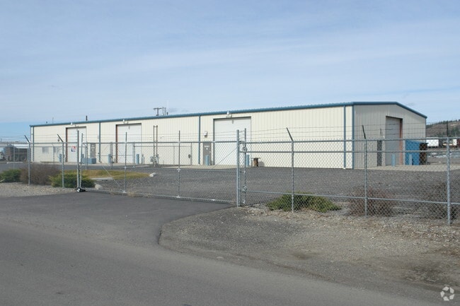
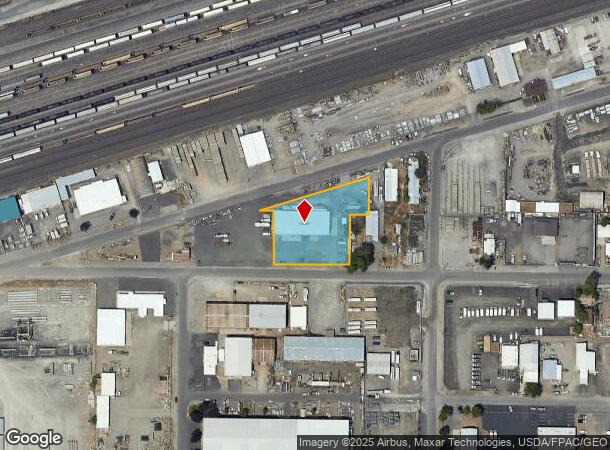
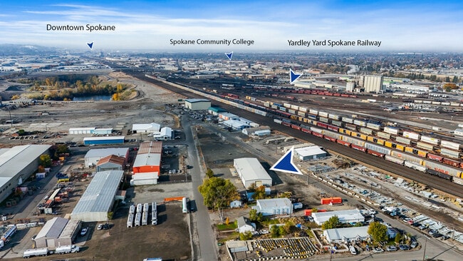
Property Record
5401 E Sharp Ave, Spokane Valley, WA 99212
NEARBY LISTINGS FOR SALE OR LEASE
Property Detail
5401 E Sharp Ave
Spokane-Spokane Valley, WA
The Town Of Yardley
35141.0418
YARDLEY: LOTS 5 THRU 8 AND LOT 13, OF BLOCK 25; TOGETHER WITH THAT PORTION OF THE NORTH HALF OF THE VACATED ALLEY, ADJOINING AND LYING WEST OF THE PROLONGATED EAST LINE OF LOT 13, AND TOGETHER WITH THE SOUTH HALF OF THE VACATED ALLEY ADJOINING TO LOT
Wholesaleoutletdiscountstore
Spokane
X
Washington
53063C0562D
5,13
2025
0.97 AC
2025
Valley
012200
Spokane
9,470 SF
DEMOGRAPHICS near 5401 E Sharp Ave
1 Mile
3 Mile
5 Mile
2024 Total Population
2,462
68,514
230,669
2029 Population
2,619
72,940
245,647
Pop Growth 2024-2029
+ 6.38%
+ 6.46%
+ 6.49%
Average Age
35
39
39
2024 Total Households
1,122
27,131
95,651
HH Growth 2024-2029
+ 6.42%
+ 6.61%
+ 6.77%
Median Household Inc
$46,638
$59,557
$57,341
Avg Household Size
2.20
2.40
2.30
2024 Avg HH Vehicles
2.00
2.00
2.00
Median Home Value
$159,027
$278,231
$311,958
Median Year Built
1995
1968
1970
Nearby Places
Map Layers
Map Styles
 Street
 Aerial
- Restaurants
- Banks
- Shops
- Fitness
- Groceries
PUBLIC TRANSPORTATION
COMMUTER RAIL
Spokane (Empire Builder - Amtrak)
DRIVE
WALK
Distance
Spokane (Empire Builder - Amtrak)
11 min
5.8 mi
AIRPORT
Spokane International
DRIVE
WALK
Distance
Spokane International
18 min
11.7 mi
Freight Ports
Port of Everett
DRIVE
WALK
Distance
Port of Everett
346 min
307.2 mi
SALE & LEASE HISTORY
LISTING DATE
SALE/LEASE

Oct 21, 2025
For Lease
Nearby Properties
Address
Land Use
TOTAL SIZE
Lot Size
Zoning
Address
Land Use
TOTAL SIZE
Lot Size
Zoning
917,113 SF
100.67 AC
LI
Address
Land Use
TOTAL SIZE
Lot Size
Zoning
427,054 SF
16.60 AC
LI
Address
Land Use
TOTAL SIZE
Lot Size
Zoning
251,542 SF
5.78 AC
DTG
Address
Land Use
TOTAL SIZE
Lot Size
Zoning
310,606 SF
27.56 AC
RMF
Address
Land Use
TOTAL SIZE
Lot Size
Zoning
180,822 SF
16.11 AC
CC1
Address
Land Use
TOTAL SIZE
Lot Size
Zoning
355,192 SF
35.83 AC
I-2
Address
Land Use
TOTAL SIZE
Lot Size
Zoning
379,678 SF
20.64 AC
LI
Address
Land Use
TOTAL SIZE
Lot Size
Zoning
378,750 SF
17.38 AC
R-2
Address
Land Use
TOTAL SIZE
Lot Size
Zoning
91,310 SF
2.34 AC
Address
Land Use
TOTAL SIZE
Lot Size
Zoning
108,237 SF
3.48 AC
LI
Address
Land Use
TOTAL SIZE
Lot Size
Zoning
58,522 SF
19.91 AC
HI
Address
Land Use
TOTAL SIZE
Lot Size
Zoning
134,806 SF
7.79 AC
RMF
Address
Land Use
TOTAL SIZE
Lot Size
Zoning
160,810 SF
25.18 AC
RMF
Address
Land Use
TOTAL SIZE
Lot Size
Zoning
96,424 SF
9.04 AC
I-1
Address
Land Use
TOTAL SIZE
Lot Size
Zoning
75,680 SF
3.93 AC
RSF
Address
Land Use
TOTAL SIZE
Lot Size
Zoning
107,442 SF
5.57 AC
MF-2
Address
Land Use
TOTAL SIZE
Lot Size
Zoning
133,043 SF
1.85 AC
CC1
Address
Land Use
TOTAL SIZE
Lot Size
Zoning
134,104 SF
5.89 AC
HDR
Address
Land Use
TOTAL SIZE
Lot Size
Zoning
150,812 SF
17.49 AC
RC
Address
Land Use
TOTAL SIZE
Lot Size
Zoning
107,539 SF
7.54 AC
RMF
Address
Land Use
TOTAL SIZE
Lot Size
Zoning
50,179 SF
5.54 AC
RSF
Address
Land Use
TOTAL SIZE
Lot Size
Zoning
102,441 SF
8.38 AC
Address
Land Use
TOTAL SIZE
Lot Size
Zoning
118,818 SF
7.96 AC
HDR
Address
Land Use
TOTAL SIZE
Lot Size
Zoning
138,078 SF
8.44 AC
HI
Address
Land Use
TOTAL SIZE
Lot Size
Zoning
60,484 SF
2.38 AC
LI
Address
Land Use
TOTAL SIZE
Lot Size
Zoning
91,811 SF
6.02 AC
LI
Address
Land Use
TOTAL SIZE
Lot Size
Zoning
71,803 SF
2.34 AC
RMF
Address
Land Use
TOTAL SIZE
Lot Size
Zoning
104,760 SF
6.96 AC
HDR
Address
Land Use
TOTAL SIZE
Lot Size
Zoning
38,889 SF
114.18 AC
LI
Address
Land Use
TOTAL SIZE
Lot Size
Zoning
200 SF
159.15 AC
LI
The World's #1 Commercial Real Estate Marketplace
Connect with us
© 2026 CoStar Group
The information above has been obtained from sources believed reliable. While we do not doubt its accuracy we have not verified it and make no guarantee, warranty or representation about it. It is your responsibility to independently confirm its accuracy and completeness. Any projections, opinions, assumptions, or estimates used are for example only and do not represent the current or future performance of the property. The value of this transaction to you depends on tax and other factors which should be evaluated by your tax, financial, and legal advisors. You and your advisors should conduct a careful, independent investigation of the property to determine to your satisfaction the suitability of the property for your needs.