Property Record
5401 E State Highway Aa, Springfield, MO 65803
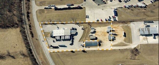

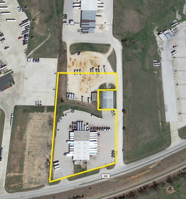
Property Detail
5401 E State Highway Aa
12-01-100-069
6.5A M/L BEG 893 FT S NW COR W1/2 LOT 2 NE1/4 E 300 FT S TO OLD HWY 66 SWLY313.83 FT ALG HWY N TO BEG 1/29/21
Truckterminal
GREENE
M-1
Missouri
B and X Area of moderate flood hazard, usually the area between the limits of the 100-year and 500-year floods.
2
2025
6.50 AC
2025
Outlying Greene County
004402
Springfield
17,080 SF
Springfield, MO
NEARBY LISTINGS FOR SALE OR LEASE
DEMOGRAPHICS near 5401 E State Highway Aa
1 mile
3 mile
5 mile
2025 Total Population
165
4,784
29,951
2030 Population
172
4,971
30,928
Pop Growth 2025-2030
+ 4.24%
+ 3.91%
+ 3.26%
Average Age
40
43
41
2025 Total Households
68
1,941
12,861
HH Growth 2025-2030
+ 4.41%
+ 4.02%
+ 3.41%
Median Household Inc
$69,999
$104,652
$67,283
Avg Household Size
2.40
2.40
2.30
2025 Avg HH Vehicles
2.00
2.00
2.00
Median Home Value
$299,999
$351,988
$262,622
Median Year Built
1996
2000
1984
Nearby Places
Map Layers
Map Styles
 Street
 Aerial
Transit
 Traffic
 Biking
Places
Listings with unknown addresses are not visible on the map
- Restaurants
- Banks
- Shops
- Fitness
- Groceries
PUBLIC TRANSPORTATION
AIRPORT
Springfield-Branson Ntl
Drive
Walk
Distance
Springfield-Branson Ntl
25 min
15.9 mi
SALE & LEASE HISTORY
LISTING DATE
SALE/LEASE

Sep 26, 2016
For Lease
Apr 11, 2019
For Lease
Nearby Properties
Address
Land Use
TOTAL SIZE
Lot Size
Zoning
Address
Land Use
TOTAL SIZE
Lot Size
Zoning
68.92 AC
INC
Address
Land Use
TOTAL SIZE
Lot Size
Zoning
617,990 SF
49.88 AC
INC
Address
Land Use
TOTAL SIZE
Lot Size
Zoning
20.01 AC
Address
Land Use
TOTAL SIZE
Lot Size
Zoning
22.01 AC
INC.
Address
Land Use
TOTAL SIZE
Lot Size
Zoning
37.01 AC
INC
Address
Land Use
TOTAL SIZE
Lot Size
Zoning
349,216 SF
29.46 AC
INC
Address
Land Use
TOTAL SIZE
Lot Size
Zoning
9.17 AC
INC.
Address
Land Use
TOTAL SIZE
Lot Size
Zoning
24.54 AC
INC.
Address
Land Use
TOTAL SIZE
Lot Size
Zoning
127,740 SF
27.70 AC
INC
Address
Land Use
TOTAL SIZE
Lot Size
Zoning
92,702 SF
42.54 AC
INC
Address
Land Use
TOTAL SIZE
Lot Size
Zoning
110,347 SF
14.58 AC
INC
Address
Land Use
TOTAL SIZE
Lot Size
Zoning
256,172 SF
19.03 AC
INC
Address
Land Use
TOTAL SIZE
Lot Size
Zoning
8.66 AC
INC
Address
Land Use
TOTAL SIZE
Lot Size
Zoning
79.50 AC
INC
Address
Land Use
TOTAL SIZE
Lot Size
Zoning
31.56 AC
INC
Address
Land Use
TOTAL SIZE
Lot Size
Zoning
328,252 SF
18.67 AC
INC
Address
Land Use
TOTAL SIZE
Lot Size
Zoning
32.40 AC
INC
Address
Land Use
TOTAL SIZE
Lot Size
Zoning
16.03 AC
INC
Address
Land Use
TOTAL SIZE
Lot Size
Zoning
11.68 AC
INC
Address
Land Use
TOTAL SIZE
Lot Size
Zoning
70,284 SF
22.88 AC
INC
Address
Land Use
TOTAL SIZE
Lot Size
Zoning
491,910 SF
49.03 AC
INC
Address
Land Use
TOTAL SIZE
Lot Size
Zoning
10.11 AC
INC
Address
Land Use
TOTAL SIZE
Lot Size
Zoning
54,952 SF
9.29 AC
INC
Address
Land Use
TOTAL SIZE
Lot Size
Zoning
8.82 AC
INC
Address
Land Use
TOTAL SIZE
Lot Size
Zoning
4.75 AC
INC
Address
Land Use
TOTAL SIZE
Lot Size
Zoning
129,666 SF
13.73 AC
INC
Address
Land Use
TOTAL SIZE
Lot Size
Zoning
67,502 SF
7.70 AC
INC
Address
Land Use
TOTAL SIZE
Lot Size
Zoning
102,824 SF
7.46 AC
M-1
Address
Land Use
TOTAL SIZE
Lot Size
Zoning
84,784 SF
9.02 AC
INC
Address
Land Use
TOTAL SIZE
Lot Size
Zoning
75,471 SF
22.31 AC
INC
The World's #1 Commercial Real Estate Marketplace
Connect with us
© 2026 CoStar Group
The information above has been obtained from sources believed reliable. While we do not doubt its accuracy we have not verified it and make no guarantee, warranty or representation about it. It is your responsibility to independently confirm its accuracy and completeness. Any projections, opinions, assumptions, or estimates used are for example only and do not represent the current or future performance of the property. The value of this transaction to you depends on tax and other factors which should be evaluated by your tax, financial, and legal advisors. You and your advisors should conduct a careful, independent investigation of the property to determine to your satisfaction the suitability of the property for your needs.