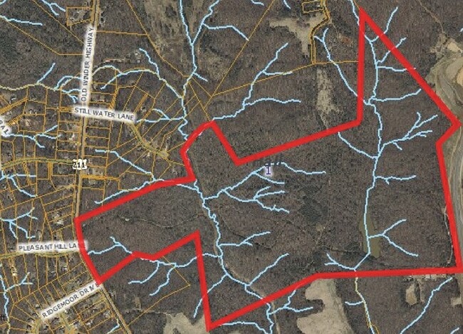
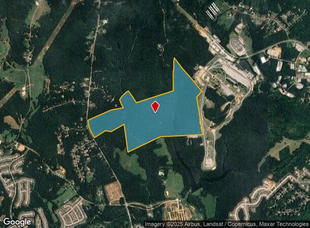
Property Record
5401 Old Winder Hwy, Braselton, GA 30517
NEARBY LISTINGS FOR SALE OR LEASE
Property Detail
5401 Old Winder Hwy
Gainesville, GA
OLD WINDER HIGHWAY
15-0039A-00-007
Hall
Agriculturalland
Georgia
A
0
13013C0025D
279.02 AC
2025
Gainesville/Hall County
2025
Atlanta
001603
DEMOGRAPHICS near 5401 Old Winder Hwy
1 Mile
3 Mile
5 Mile
2024 Total Population
528
24,430
68,350
2029 Population
580
27,767
77,439
Pop Growth 2024-2029
+ 9.85%
+ 13.66%
+ 13.30%
Average Age
40
41
40
2024 Total Households
182
8,568
23,061
HH Growth 2024-2029
+ 9.89%
+ 13.07%
+ 13.13%
Median Household Inc
$68,194
$101,619
$95,872
Avg Household Size
2.90
2.80
2.90
2024 Avg HH Vehicles
3.00
2.00
2.00
Median Home Value
$275,961
$350,805
$334,628
Median Year Built
2000
2006
2004
Nearby Places
Map Layers
Map Styles
 Street
 Aerial
- Restaurants
- Banks
- Shops
- Fitness
- Groceries
SALE & LEASE HISTORY
LISTING DATE
SALE/LEASE

Aug 24, 2023
For Sale
Nearby Properties
Address
Land Use
TOTAL SIZE
Lot Size
Zoning
Address
Land Use
TOTAL SIZE
Lot Size
Zoning
105,000 SF
104.18 AC
POD
Address
Land Use
TOTAL SIZE
Lot Size
Zoning
381,371 SF
77.27 AC
PUD
Address
Land Use
TOTAL SIZE
Lot Size
Zoning
510,720 SF
48.46 AC
M1
Address
Land Use
TOTAL SIZE
Lot Size
Zoning
114,835 SF
15.29 AC
POD
Address
Land Use
TOTAL SIZE
Lot Size
Zoning
46,400 SF
3.51 AC
G-C
Address
Land Use
TOTAL SIZE
Lot Size
Zoning
110,886 SF
34.34 AC
POD
Address
Land Use
TOTAL SIZE
Lot Size
Zoning
9,800 SF
681.58 AC
PCD
Address
Land Use
TOTAL SIZE
Lot Size
Zoning
95,723 SF
84 AC
AR-1
Address
Land Use
TOTAL SIZE
Lot Size
Zoning
44,824 SF
3.22 AC
G-C
Address
Land Use
TOTAL SIZE
Lot Size
Zoning
24,486 SF
3.85 AC
G-C
Address
Land Use
TOTAL SIZE
Lot Size
Zoning
18,510 SF
490.78 AC
PRD/PCD
Address
Land Use
TOTAL SIZE
Lot Size
Zoning
1,280 SF
24.21 AC
PCD
Address
Land Use
TOTAL SIZE
Lot Size
Zoning
42,848 SF
4.55 AC
G-C
Address
Land Use
TOTAL SIZE
Lot Size
Zoning
76,566 SF
10.33 AC
PUD
Address
Land Use
TOTAL SIZE
Lot Size
Zoning
24,290 SF
6.15 AC
PUD
Address
Land Use
TOTAL SIZE
Lot Size
Zoning
1,412 SF
43 AC
OI
Address
Land Use
TOTAL SIZE
Lot Size
Zoning
29,212 SF
2.64 AC
N-C
Address
Land Use
TOTAL SIZE
Lot Size
Zoning
22.22 AC
OI
Address
Land Use
TOTAL SIZE
Lot Size
Zoning
31,040 SF
3.68 AC
PUD
Address
Land Use
TOTAL SIZE
Lot Size
Zoning
7.60 AC
AR-1
Address
Land Use
TOTAL SIZE
Lot Size
Zoning
4.81 AC
AR-1
Address
Land Use
TOTAL SIZE
Lot Size
Zoning
21.83 AC
PUD
Address
Land Use
TOTAL SIZE
Lot Size
Zoning
12,243 SF
1.91 AC
G-C
Address
Land Use
TOTAL SIZE
Lot Size
Zoning
24,800 SF
2.57 AC
PUD
Address
Land Use
TOTAL SIZE
Lot Size
Zoning
59,160 SF
19.72 AC
I-2
Address
Land Use
TOTAL SIZE
Lot Size
Zoning
21,696 SF
1.01 AC
PUD
Address
Land Use
TOTAL SIZE
Lot Size
Zoning
7,500 SF
5 AC
I-2
Address
Land Use
TOTAL SIZE
Lot Size
Zoning
14,710 SF
1.43 AC
PUD
Address
Land Use
TOTAL SIZE
Lot Size
Zoning
42,848 SF
14.84 AC
G-C
Address
Land Use
TOTAL SIZE
Lot Size
Zoning
8,902 SF
1.44 AC
G-C
The World's #1 Commercial Real Estate Marketplace
Connect with us
© 2026 CoStar Group
The information above has been obtained from sources believed reliable. While we do not doubt its accuracy we have not verified it and make no guarantee, warranty or representation about it. It is your responsibility to independently confirm its accuracy and completeness. Any projections, opinions, assumptions, or estimates used are for example only and do not represent the current or future performance of the property. The value of this transaction to you depends on tax and other factors which should be evaluated by your tax, financial, and legal advisors. You and your advisors should conduct a careful, independent investigation of the property to determine to your satisfaction the suitability of the property for your needs.