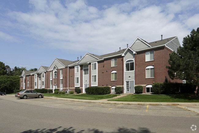
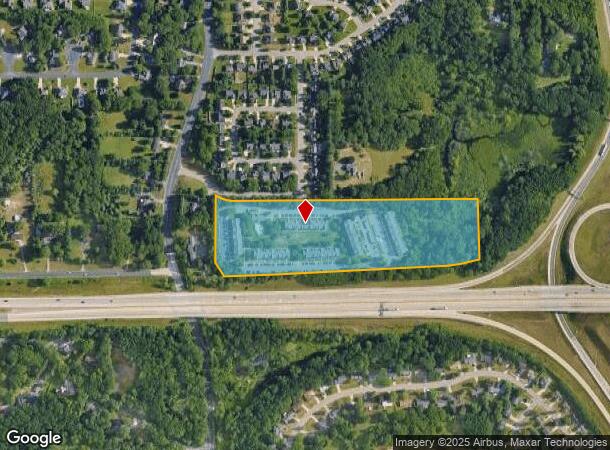
Property Record
5401 S 12Th St, Portage, MI 49024

NEARBY LISTINGS FOR SALE OR LEASE
-
-
View all Portage listings for sale on LoopNet.com
Property Detail
5401 S 12Th St
10-00006-045-J
SEC.6 T3S R11W PART NW1/4 COM 1537.09 FT S & S17DEG W 395.40 FT TO S LINE OF FOX VALLEY BLVD.& SE'LY ALG SD R/W TO W SEC LINE
Commercialnec
Kalamazoo
X
Michigan
26077C0285E
15 AC
2025
Portage
2025
West Michigan
003007
Kalamazoo-Portage, MI
23,463 SF
DEMOGRAPHICS near 5401 S 12Th St
1 Mile
3 Mile
5 Mile
2024 Total Population
5,005
56,312
137,559
2029 Population
4,949
56,172
137,495
Pop Growth 2024-2029
(1.12%)
(0.25%)
(0.05%)
Average Age
39
37
37
2024 Total Households
2,055
23,681
57,723
HH Growth 2024-2029
(1.22%)
(0.22%)
(0.03%)
Median Household Inc
$86,680
$62,288
$58,489
Avg Household Size
2.40
2.30
2.20
2024 Avg HH Vehicles
2.00
2.00
2.00
Median Home Value
$232,022
$242,177
$211,793
Median Year Built
1990
1980
1974
Nearby Places
Map Layers
Map Styles
 Street
 Aerial
- Restaurants
- Banks
- Shops
- Fitness
- Groceries
PUBLIC TRANSPORTATION
COMMUTER RAIL
DRIVE
WALK
Distance
17 min
6.8 mi
AIRPORT
Kalamazoo/Battle Creek International
DRIVE
WALK
Distance
Kalamazoo/Battle Creek International
20 min
7.5 mi
Nearby Properties
Address
Land Use
TOTAL SIZE
Lot Size
Zoning
Address
Land Use
TOTAL SIZE
Lot Size
Zoning
374,906 SF
16.31 AC
RM-36
Address
Land Use
TOTAL SIZE
Lot Size
Zoning
1,703 SF
20.29 AC
R-2
Address
Land Use
TOTAL SIZE
Lot Size
Zoning
204,579 SF
27.80 AC
R-4 MUL
Address
Land Use
TOTAL SIZE
Lot Size
Zoning
424,967 SF
55.60 AC
I-1
Address
Land Use
TOTAL SIZE
Lot Size
Zoning
449,275 SF
33.70 AC
R-4 MUL
Address
Land Use
TOTAL SIZE
Lot Size
Zoning
331,571 SF
19.68 AC
RM-15
Address
Land Use
TOTAL SIZE
Lot Size
Zoning
383,638 SF
25.85 AC
B-2
Address
Land Use
TOTAL SIZE
Lot Size
Zoning
315,422 SF
25.40 AC
RM-15
Address
Land Use
TOTAL SIZE
Lot Size
Zoning
17.31 AC
PD
Address
Land Use
TOTAL SIZE
Lot Size
Zoning
105,046 SF
19.30 AC
RM-15
Address
Land Use
TOTAL SIZE
Lot Size
Zoning
16.71 AC
B-2
Address
Land Use
TOTAL SIZE
Lot Size
Zoning
140,000 SF
22.69 AC
EBT
Address
Land Use
TOTAL SIZE
Lot Size
Zoning
230,820 SF
16.50 AC
R-4 MUL
Address
Land Use
TOTAL SIZE
Lot Size
Zoning
5.04 AC
CPD
Address
Land Use
TOTAL SIZE
Lot Size
Zoning
128,586 SF
14.27 AC
R-4 MUL
Address
Land Use
TOTAL SIZE
Lot Size
Zoning
5,173 SF
15.81 AC
RM-1
Address
Land Use
TOTAL SIZE
Lot Size
Zoning
61,533 SF
8.42 AC
B-2
Address
Land Use
TOTAL SIZE
Lot Size
Zoning
4.33 AC
C-1
Address
Land Use
TOTAL SIZE
Lot Size
Zoning
224,424 SF
18.89 AC
R-4 MUL
Address
Land Use
TOTAL SIZE
Lot Size
Zoning
12,480 SF
14.82 AC
RM-1
Address
Land Use
TOTAL SIZE
Lot Size
Zoning
179,628 SF
12.99 AC
RM-15
Address
Land Use
TOTAL SIZE
Lot Size
Zoning
6,874 SF
163.50 AC
PD
Address
Land Use
TOTAL SIZE
Lot Size
Zoning
2.31 AC
CPD
Address
Land Use
TOTAL SIZE
Lot Size
Zoning
4.65 AC
CPD
Address
Land Use
TOTAL SIZE
Lot Size
Zoning
26,700 SF
17 AC
RM-1
Address
Land Use
TOTAL SIZE
Lot Size
Zoning
133,976 SF
15.04 AC
CPD
Address
Land Use
TOTAL SIZE
Lot Size
Zoning
8.83 AC
I-1
Address
Land Use
TOTAL SIZE
Lot Size
Zoning
178,882 SF
10.02 AC
RS-5
Address
Land Use
TOTAL SIZE
Lot Size
Zoning
25,000 SF
5.63 AC
B-3
The World's #1 Commercial Real Estate Marketplace
Connect with us
© 2026 CoStar Group
The information above has been obtained from sources believed reliable. While we do not doubt its accuracy we have not verified it and make no guarantee, warranty or representation about it. It is your responsibility to independently confirm its accuracy and completeness. Any projections, opinions, assumptions, or estimates used are for example only and do not represent the current or future performance of the property. The value of this transaction to you depends on tax and other factors which should be evaluated by your tax, financial, and legal advisors. You and your advisors should conduct a careful, independent investigation of the property to determine to your satisfaction the suitability of the property for your needs.