Property Record
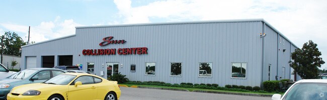
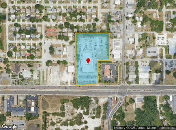
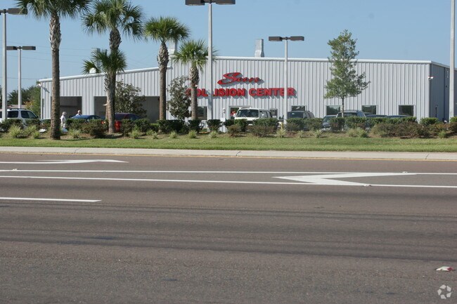
5401 State Road 54, New Port Richey, FL 34652

NEARBY LISTINGS FOR SALE OR LEASE
Property Detail
5401 State Road 54
Tampa-St. Petersburg-Clearwater, FL
Spring Lake Estates
17-26-16-0000-01000-0000
EAST 400 FT OF SE1/4 OF SE1/4 OF SW1/4 OF SEC EXC RD R/W & POR OF WEST 35 FT OF SW1/4 OF SE1/4 LYING SLY & WLY OF FOLL PARCEL COM AT SE COR OF SPRING LAKE ESTATES UNIT 3 PER PB 9 PG 168 TH S00DEG2010W 136.69 FT TH S89DEG2016E 1.93 FT FOR POB TH S89DE
Vehiclerentalsvehiclesales
Pasco
X
Florida
12101C0353G
1
2024
5.09 AC
2025
Pasco County
030700
Tampa/St Petersburg
31,387 SF
DEMOGRAPHICS near 5401 State Road 54
1 Mile
3 Mile
5 Mile
2024 Total Population
15,903
98,644
166,761
2029 Population
19,129
119,355
198,905
Pop Growth 2024-2029
+ 20.29%
+ 21.00%
+ 19.28%
Average Age
42
44
45
2024 Total Households
6,605
43,341
72,596
HH Growth 2024-2029
+ 20.27%
+ 21.05%
+ 19.36%
Median Household Inc
$46,076
$44,213
$48,435
Avg Household Size
2.40
2.20
2.20
2024 Avg HH Vehicles
2.00
2.00
2.00
Median Home Value
$124,958
$154,696
$187,505
Median Year Built
1974
1977
1980
Nearby Places
Map Layers
Map Styles
 Street
 Aerial
- Restaurants
- Banks
- Shops
- Fitness
- Groceries
PUBLIC TRANSPORTATION
AIRPORT
St Pete-Clearwater International
DRIVE
WALK
Distance
St Pete-Clearwater International
48 min
28.3 mi
Tampa International
DRIVE
WALK
Distance
Tampa International
47 min
32.0 mi
Nearby Properties
Address
Land Use
TOTAL SIZE
Lot Size
Zoning
Address
Land Use
TOTAL SIZE
Lot Size
Zoning
384,700 SF
18.90 AC
MF3
Address
Land Use
TOTAL SIZE
Lot Size
Zoning
248,561 SF
14.17 AC
C
Address
Land Use
TOTAL SIZE
Lot Size
Zoning
314,948 SF
55.04 AC
MPUD
Address
Land Use
TOTAL SIZE
Lot Size
Zoning
241,429 SF
37.59 AC
C
Address
Land Use
TOTAL SIZE
Lot Size
Zoning
162,716 SF
16.56 AC
MF1
Address
Land Use
TOTAL SIZE
Lot Size
Zoning
171,378 SF
17.35 AC
MF1
Address
Land Use
TOTAL SIZE
Lot Size
Zoning
149,162 SF
3.10 AC
C
Address
Land Use
TOTAL SIZE
Lot Size
Zoning
193,971 SF
4.50 AC
C1
Address
Land Use
TOTAL SIZE
Lot Size
Zoning
163,106 SF
13.97 AC
C
Address
Land Use
TOTAL SIZE
Lot Size
Zoning
145,216 SF
7.58 AC
MF3
Address
Land Use
TOTAL SIZE
Lot Size
Zoning
91,660 SF
16.29 AC
C
Address
Land Use
TOTAL SIZE
Lot Size
Zoning
135,600 SF
13.34 AC
MF1
Address
Land Use
TOTAL SIZE
Lot Size
Zoning
121,869 SF
4.72 AC
C2
Address
Land Use
TOTAL SIZE
Lot Size
Zoning
43,469 SF
11.48 AC
MPUD
Address
Land Use
TOTAL SIZE
Lot Size
Zoning
81,045 SF
16.34 AC
PUD
Address
Land Use
TOTAL SIZE
Lot Size
Zoning
112,703 SF
8.43 AC
C2
Address
Land Use
TOTAL SIZE
Lot Size
Zoning
16,510 SF
41.69 AC
R1
Address
Land Use
TOTAL SIZE
Lot Size
Zoning
77,900 SF
10.52 AC
C2
Address
Land Use
TOTAL SIZE
Lot Size
Zoning
142,856 SF
20 AC
C
Address
Land Use
TOTAL SIZE
Lot Size
Zoning
82,047 SF
21.48 AC
MF2
Address
Land Use
TOTAL SIZE
Lot Size
Zoning
93,304 SF
18.82 AC
MF1
Address
Land Use
TOTAL SIZE
Lot Size
Zoning
133,304 SF
13.48 AC
C2
Address
Land Use
TOTAL SIZE
Lot Size
Zoning
81,272 SF
47.25 AC
MF2
Address
Land Use
TOTAL SIZE
Lot Size
Zoning
22,216 SF
7.20 AC
C2
Address
Land Use
TOTAL SIZE
Lot Size
Zoning
72,796 SF
2.62 AC
MF3
Address
Land Use
TOTAL SIZE
Lot Size
Zoning
212,308 SF
10.91 AC
MF2
Address
Land Use
TOTAL SIZE
Lot Size
Zoning
65,939 SF
7.23 AC
C2
Address
Land Use
TOTAL SIZE
Lot Size
Zoning
41,156 SF
2.26 AC
C
Address
Land Use
TOTAL SIZE
Lot Size
Zoning
61,480 SF
7.23 AC
PUD
Address
Land Use
TOTAL SIZE
Lot Size
Zoning
91,835 SF
6.82 AC
C2
The World's #1 Commercial Real Estate Marketplace
Connect with us
© 2025 CoStar Group
The information above has been obtained from sources believed reliable. While we do not doubt its accuracy we have not verified it and make no guarantee, warranty or representation about it. It is your responsibility to independently confirm its accuracy and completeness. Any projections, opinions, assumptions, or estimates used are for example only and do not represent the current or future performance of the property. The value of this transaction to you depends on tax and other factors which should be evaluated by your tax, financial, and legal advisors. You and your advisors should conduct a careful, independent investigation of the property to determine to your satisfaction the suitability of the property for your needs.