Property Record
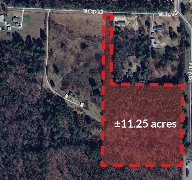
5401 Talley Rd, Little Rock, AR 72204
This Property Is For Sale
NEARBY LISTINGS FOR SALE OR LEASE
Property Detail
5401 Talley Rd
44L-143-00-025-00
PT NE SE COM NW COR S88*4623E565.51 TO POB S0*5334W1317.19 TO SLN S88*4627E741.06 TO SE COR N657.43 N88*4623W660 N660 N88*4623W60.47 TO POB 21-1N-13W
Agriculturalland
Pulaski
X
Arkansas
05125C0250E
11.25 AC
2025
Outlying Pulaski County
2025
Little Rock/N Little Rock
002405
Little Rock-North Little Rock-Conway, AR
DEMOGRAPHICS near 5401 Talley Rd
1 Mile
3 Mile
5 Mile
2024 Total Population
2,595
34,787
126,415
2029 Population
2,637
34,680
126,555
Pop Growth 2024-2029
+ 1.62%
(0.31%)
+ 0.11%
Average Age
40
38
37
2024 Total Households
1,052
14,842
53,897
HH Growth 2024-2029
+ 1.62%
(0.37%)
+ 0.09%
Median Household Inc
$51,583
$48,791
$47,772
Avg Household Size
2.40
2.30
2.30
2024 Avg HH Vehicles
2.00
2.00
2.00
Median Home Value
$167,073
$153,576
$157,918
Median Year Built
2001
1983
1978
Nearby Places
- Restaurants
- Banks
- Shops
- Fitness
- Groceries
PUBLIC TRANSPORTATION
COMMUTER RAIL
Little Rock Union Station (Texas Eagle - Amtrak)
DRIVE
WALK
Distance
Little Rock Union Station (Texas Eagle - Amtrak)
17 min
9.9 mi
AIRPORT
Bill and Hillary Clinton Ntl/Adams Field
DRIVE
WALK
Distance
Bill and Hillary Clinton Ntl/Adams Field
21 min
11.2 mi
Freight Ports
Port of Shreveport
DRIVE
WALK
Distance
Port of Shreveport
244 min
226.9 mi
Nearby Properties
Address
Land Use
TOTAL SIZE
Lot Size
Zoning
Address
Land Use
TOTAL SIZE
Lot Size
Zoning
1,665,090 SF
34.75 AC
Address
Land Use
TOTAL SIZE
Lot Size
Zoning
143,885 SF
14.98 AC
Address
Land Use
TOTAL SIZE
Lot Size
Zoning
220,563 SF
12.36 AC
Address
Land Use
TOTAL SIZE
Lot Size
Zoning
140,675 SF
Address
Land Use
TOTAL SIZE
Lot Size
Zoning
130,800 SF
7.78 AC
Address
Land Use
TOTAL SIZE
Lot Size
Zoning
221,911 SF
10.31 AC
Address
Land Use
TOTAL SIZE
Lot Size
Zoning
57,494 SF
9.53 AC
Address
Land Use
TOTAL SIZE
Lot Size
Zoning
221,204 SF
4.54 AC
Address
Land Use
TOTAL SIZE
Lot Size
Zoning
54,284 SF
11.33 AC
Address
Land Use
TOTAL SIZE
Lot Size
Zoning
185,873 SF
Address
Land Use
TOTAL SIZE
Lot Size
Zoning
26,199 SF
19.22 AC
Address
Land Use
TOTAL SIZE
Lot Size
Zoning
74,220 SF
15.49 AC
Address
Land Use
TOTAL SIZE
Lot Size
Zoning
14,902 SF
5.04 AC
Address
Land Use
TOTAL SIZE
Lot Size
Zoning
13,888 SF
21.57 AC
Address
Land Use
TOTAL SIZE
Lot Size
Zoning
83,852 SF
6.95 AC
Address
Land Use
TOTAL SIZE
Lot Size
Zoning
50,656 SF
8 AC
Address
Land Use
TOTAL SIZE
Lot Size
Zoning
25,152 SF
7.82 AC
Address
Land Use
TOTAL SIZE
Lot Size
Zoning
127,046 SF
5.13 AC
Address
Land Use
TOTAL SIZE
Lot Size
Zoning
59,031 SF
5.39 AC
Address
Land Use
TOTAL SIZE
Lot Size
Zoning
20,010 SF
13.38 AC
Address
Land Use
TOTAL SIZE
Lot Size
Zoning
16,430 SF
1.87 AC
Address
Land Use
TOTAL SIZE
Lot Size
Zoning
90,844 SF
11.24 AC
Address
Land Use
TOTAL SIZE
Lot Size
Zoning
119,764 SF
13.38 AC
Address
Land Use
TOTAL SIZE
Lot Size
Zoning
5,194 SF
8.46 AC
Address
Land Use
TOTAL SIZE
Lot Size
Zoning
237,927 SF
6.20 AC
Address
Land Use
TOTAL SIZE
Lot Size
Zoning
13,952 SF
12.35 AC
Address
Land Use
TOTAL SIZE
Lot Size
Zoning
63,488 SF
3.02 AC
Address
Land Use
TOTAL SIZE
Lot Size
Zoning
54,064 SF
3.15 AC
Address
Land Use
TOTAL SIZE
Lot Size
Zoning
184,893 SF
22.95 AC
Address
Land Use
TOTAL SIZE
Lot Size
Zoning
4,104 SF
10.29 AC
The World's #1 Commercial Real Estate Marketplace
Connect with us
© 2025 CoStar Group
The information above has been obtained from sources believed reliable. While we do not doubt its accuracy we have not verified it and make no guarantee, warranty or representation about it. It is your responsibility to independently confirm its accuracy and completeness. Any projections, opinions, assumptions, or estimates used are for example only and do not represent the current or future performance of the property. The value of this transaction to you depends on tax and other factors which should be evaluated by your tax, financial, and legal advisors. You and your advisors should conduct a careful, independent investigation of the property to determine to your satisfaction the suitability of the property for your needs.