Property Record
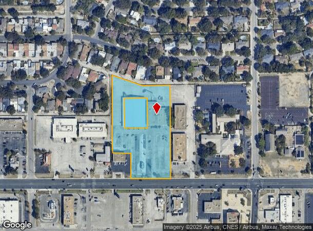
5401 Walzem Rd, Windcrest, TX 78218


NEARBY LISTINGS FOR SALE OR LEASE
Property Detail
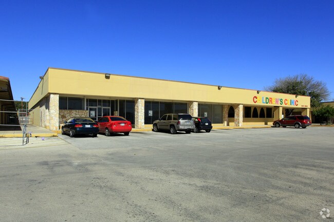
5401 Walzem Rd
San Antonio-New Braunfels, TX
Square Sub
05474-307-0030
CB 5474C BLK 107 LOT EXE 153.72X197.97 OF 3 RED TREE SQUARE SUBD 2016-SPLIT PER CR#38661PLAT 9564/215
Regionalshoppingcenterormallwithanchorstore
Bexar
X
Texas
48029C0270G
3
2024
4.43 AC
2025
Northeast
121300
San Antonio
16,200 SF
DEMOGRAPHICS near 5401 Walzem Rd
1 Mile
3 Mile
5 Mile
2024 Total Population
9,701
111,897
286,024
2029 Population
10,289
118,984
304,186
Pop Growth 2024-2029
+ 6.06%
+ 6.33%
+ 6.35%
Average Age
41
37
37
2024 Total Households
3,812
42,088
105,619
HH Growth 2024-2029
+ 6.14%
+ 6.45%
+ 6.44%
Median Household Inc
$52,500
$53,409
$60,495
Avg Household Size
2.50
2.60
2.60
2024 Avg HH Vehicles
2.00
2.00
2.00
Median Home Value
$215,640
$170,555
$182,788
Median Year Built
1977
1981
1984
Nearby Places
Map Layers
Map Styles
 Street
 Aerial
- Restaurants
- Banks
- Shops
- Fitness
- Groceries
PUBLIC TRANSPORTATION
AIRPORT
San Antonio International
DRIVE
WALK
Distance
San Antonio International
11 min
6.6 mi
Freight Ports
Calhoun Port
DRIVE
WALK
Distance
Calhoun Port
181 min
148.5 mi
SALE & LEASE HISTORY
LISTING DATE
SALE/LEASE

Sep 24, 2016
For Sale
Feb 20, 2018
For Lease
Aug 11, 2017
For Lease
Nearby Properties
Address
Land Use
TOTAL SIZE
Lot Size
Zoning
Address
Land Use
TOTAL SIZE
Lot Size
Zoning
1,649,488 SF
70 AC
Address
Land Use
TOTAL SIZE
Lot Size
Zoning
727,299 SF
47.68 AC
Address
Land Use
TOTAL SIZE
Lot Size
Zoning
25,513 SF
18.14 AC
Address
Land Use
TOTAL SIZE
Lot Size
Zoning
359,349 SF
23.59 AC
Address
Land Use
TOTAL SIZE
Lot Size
Zoning
347,943 SF
10.07 AC
Address
Land Use
TOTAL SIZE
Lot Size
Zoning
239,264 SF
9.02 AC
Address
Land Use
TOTAL SIZE
Lot Size
Zoning
278,406 SF
13.39 AC
Address
Land Use
TOTAL SIZE
Lot Size
Zoning
266,702 SF
13.49 AC
Address
Land Use
TOTAL SIZE
Lot Size
Zoning
288,350 SF
13.01 AC
Address
Land Use
TOTAL SIZE
Lot Size
Zoning
110,605 SF
19.95 AC
Address
Land Use
TOTAL SIZE
Lot Size
Zoning
277,887 SF
14.14 AC
Address
Land Use
TOTAL SIZE
Lot Size
Zoning
598,070 SF
46.05 AC
Address
Land Use
TOTAL SIZE
Lot Size
Zoning
328,605 SF
25.69 AC
Address
Land Use
TOTAL SIZE
Lot Size
Zoning
457,302 SF
34.40 AC
Address
Land Use
TOTAL SIZE
Lot Size
Zoning
230,659 SF
15.48 AC
Address
Land Use
TOTAL SIZE
Lot Size
Zoning
279,012 SF
12.17 AC
Address
Land Use
TOTAL SIZE
Lot Size
Zoning
180,000 SF
40.73 AC
Address
Land Use
TOTAL SIZE
Lot Size
Zoning
273,516 SF
17.50 AC
Address
Land Use
TOTAL SIZE
Lot Size
Zoning
92,859 SF
11.95 AC
Address
Land Use
TOTAL SIZE
Lot Size
Zoning
265,015 SF
12.81 AC
Address
Land Use
TOTAL SIZE
Lot Size
Zoning
337,468 SF
21.84 AC
Address
Land Use
TOTAL SIZE
Lot Size
Zoning
205,862 SF
10.79 AC
Address
Land Use
TOTAL SIZE
Lot Size
Zoning
275,327 SF
13.52 AC
Address
Land Use
TOTAL SIZE
Lot Size
Zoning
373,134 SF
16.29 AC
Address
Land Use
TOTAL SIZE
Lot Size
Zoning
222,865 SF
17.75 AC
Address
Land Use
TOTAL SIZE
Lot Size
Zoning
431,326 SF
42.70 AC
Address
Land Use
TOTAL SIZE
Lot Size
Zoning
257,263 SF
10.07 AC
Address
Land Use
TOTAL SIZE
Lot Size
Zoning
437,807 SF
24.55 AC
Address
Land Use
TOTAL SIZE
Lot Size
Zoning
391,863 SF
24.43 AC
Address
Land Use
TOTAL SIZE
Lot Size
Zoning
15.42 AC
The World's #1 Commercial Real Estate Marketplace
Connect with us
© 2026 CoStar Group
The information above has been obtained from sources believed reliable. While we do not doubt its accuracy we have not verified it and make no guarantee, warranty or representation about it. It is your responsibility to independently confirm its accuracy and completeness. Any projections, opinions, assumptions, or estimates used are for example only and do not represent the current or future performance of the property. The value of this transaction to you depends on tax and other factors which should be evaluated by your tax, financial, and legal advisors. You and your advisors should conduct a careful, independent investigation of the property to determine to your satisfaction the suitability of the property for your needs.