Property Record
5402 W Laurel St, Tampa, FL 33607
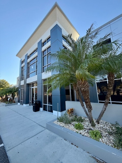


This Property Is For Sale
Current Lease Availabilities
Property Detail
5402 W Laurel St
A-18-29-18-97B-000000-0001B.0
LAUREL STREET COMMERCE CENTER A CONDOMINIUM UNIT 1B
Officebuilding
HILLSBOROUGH
PD
Florida
AE The base floodplain where base flood elevations are provided. AE Zones are now used on new format FIRMs instead of A1-A30 Zones.
1b
2024
Westshore
2025
Tampa/St Petersburg
004602
Tampa-St. Petersburg-Clearwater, FL
9,204 SF
NEARBY LISTINGS FOR SALE OR LEASE
DEMOGRAPHICS near 5402 W Laurel St
1 mile
3 mile
5 mile
2025 Total Population
2,639
57,855
223,309
2030 Population
2,862
62,254
240,180
Pop Growth 2025-2030
+ 8.45%
+ 7.60%
+ 7.56%
Average Age
40
40
40
2025 Total Households
1,309
25,392
95,319
HH Growth 2025-2030
+ 8.56%
+ 7.82%
+ 7.89%
Median Household Inc
$95,925
$98,130
$78,268
Avg Household Size
2.00
2.20
2.20
2025 Avg HH Vehicles
2.00
2.00
2.00
Median Home Value
$669,173
$652,645
$491,183
Median Year Built
1989
1984
1981
Nearby Places
Map Layers
Map Styles
 Street
 Aerial
Transit
 Traffic
 Biking
Places
Listings with unknown addresses are not visible on the map
- Restaurants
- Banks
- Shops
- Fitness
- Groceries
PUBLIC TRANSPORTATION
TRANSIT/SUBWAY
Skyconnect Rental Car Facility Station (SkyConnect - Operated By TPA - Hillsborough Area Regional Transit)
Drive
Walk
Distance
Skyconnect Rental Car Facility Station (SkyConnect - Operated By TPA - Hillsborough Area Regional Transit)
2 min
19 min
1.0 mi
COMMUTER RAIL
Tampa (Silver Star - Amtrak)
Drive
Walk
Distance
Tampa (Silver Star - Amtrak)
11 min
6.1 mi
AIRPORT
Tampa International
Drive
Walk
Distance
Tampa International
6 min
2.0 mi
St Pete-Clearwater International
Drive
Walk
Distance
St Pete-Clearwater International
26 min
13.2 mi
Freight Ports
Port of Tampa Bay
Drive
Walk
Distance
Port of Tampa Bay
19 min
9.6 mi
Nearby Properties
Address
Land Use
TOTAL SIZE
Lot Size
Zoning
Address
Land Use
TOTAL SIZE
Lot Size
Zoning
2,080,593 SF
1,915.65 AC
M-AP-1
Address
Land Use
TOTAL SIZE
Lot Size
Zoning
927,709 SF
74.68 AC
PD-A
Address
Land Use
TOTAL SIZE
Lot Size
Zoning
1,278,217 SF
0.02 AC
CI
Address
Land Use
TOTAL SIZE
Lot Size
Zoning
142,972 SF
21.79 AC
M-AP-1
Address
Land Use
TOTAL SIZE
Lot Size
Zoning
439,758 SF
22.14 AC
PD
Address
Land Use
TOTAL SIZE
Lot Size
Zoning
532,661 SF
76.96 AC
CI
Address
Land Use
TOTAL SIZE
Lot Size
Zoning
429,656 SF
6.97 AC
PD
Address
Land Use
TOTAL SIZE
Lot Size
Zoning
401,486 SF
13.22 AC
PD-A
Address
Land Use
TOTAL SIZE
Lot Size
Zoning
356,025 SF
4.57 AC
PD
Address
Land Use
TOTAL SIZE
Lot Size
Zoning
352,071 SF
21.42 AC
M-AP-2
Address
Land Use
TOTAL SIZE
Lot Size
Zoning
387,234 SF
5.31 AC
OP-1
Address
Land Use
TOTAL SIZE
Lot Size
Zoning
289,875 SF
19.58 AC
IG
Address
Land Use
TOTAL SIZE
Lot Size
Zoning
367,609 SF
5.46 AC
PD
Address
Land Use
TOTAL SIZE
Lot Size
Zoning
393,971 SF
6.85 AC
PD
Address
Land Use
TOTAL SIZE
Lot Size
Zoning
351,344 SF
84.32 AC
PD
Address
Land Use
TOTAL SIZE
Lot Size
Zoning
245,701 SF
3.15 AC
PD
Address
Land Use
TOTAL SIZE
Lot Size
Zoning
382,217 SF
29.74 AC
PD
Address
Land Use
TOTAL SIZE
Lot Size
Zoning
309,242 SF
7.44 AC
PD-A
Address
Land Use
TOTAL SIZE
Lot Size
Zoning
305,936 SF
5.47 AC
PD-A
Address
Land Use
TOTAL SIZE
Lot Size
Zoning
485,897 SF
2.90 AC
PD
Address
Land Use
TOTAL SIZE
Lot Size
Zoning
331,003 SF
3.07 AC
PD
Address
Land Use
TOTAL SIZE
Lot Size
Zoning
344,612 SF
6.09 AC
PD
Address
Land Use
TOTAL SIZE
Lot Size
Zoning
2,226 SF
438.48 AC
SPI-AP-1
Address
Land Use
TOTAL SIZE
Lot Size
Zoning
369,417 SF
13.42 AC
PD
Address
Land Use
TOTAL SIZE
Lot Size
Zoning
421,814 SF
22.34 AC
PD
Address
Land Use
TOTAL SIZE
Lot Size
Zoning
521,097 SF
30.92 AC
RMC-20
Address
Land Use
TOTAL SIZE
Lot Size
Zoning
297,410 SF
3.43 AC
PD
Address
Land Use
TOTAL SIZE
Lot Size
Zoning
365,470 SF
13.29 AC
M-AP-1
Address
Land Use
TOTAL SIZE
Lot Size
Zoning
256,605 SF
2.49 AC
PD
The World's #1 Commercial Real Estate Marketplace
Connect with us
© 2026 CoStar Group
The information above has been obtained from sources believed reliable. While we do not doubt its accuracy we have not verified it and make no guarantee, warranty or representation about it. It is your responsibility to independently confirm its accuracy and completeness. Any projections, opinions, assumptions, or estimates used are for example only and do not represent the current or future performance of the property. The value of this transaction to you depends on tax and other factors which should be evaluated by your tax, financial, and legal advisors. You and your advisors should conduct a careful, independent investigation of the property to determine to your satisfaction the suitability of the property for your needs.