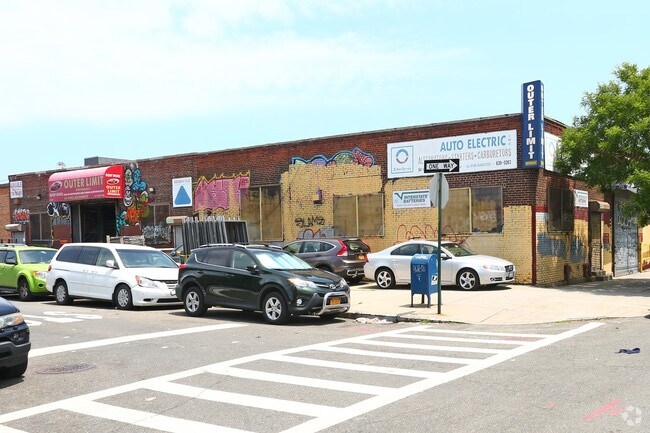
Property Record
5403 37Th Ave, Woodside, NY 11377

Property Detail
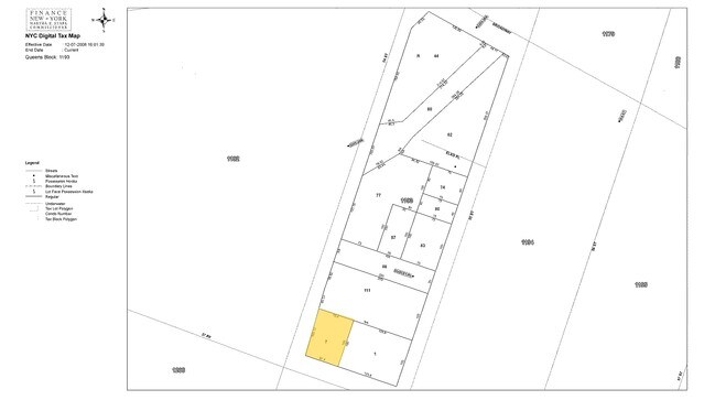
5403 37Th Ave
01193-0007
Queens
Industrialgeneral
New York
M1-1
7
B and X Area of moderate flood hazard, usually the area between the limits of the 100-year and 500-year floods.
0.16 AC
2025
Northwest Queens
2026
Long Island (New York)
025500
New York-Jersey City-White Plains, NY-NJ
3,450 SF
NEARBY LISTINGS FOR SALE OR LEASE
DEMOGRAPHICS near 5403 37Th Ave
1 mile
3 mile
5 mile
2025 Total Population
146,422
976,931
3,044,502
2030 Population
145,941
979,402
3,091,659
Pop Growth 2025-2030
(0.33%)
+ 0.25%
+ 1.55%
Average Age
42
41
40
2025 Total Households
56,394
389,054
1,272,332
HH Growth 2025-2030
(0.48%)
+ 0.73%
+ 2.05%
Median Household Inc
$76,668
$92,875
$90,704
Avg Household Size
2.50
2.40
2.30
2025 Avg HH Vehicles
1.00
1.00
.00
Median Home Value
$668,925
$796,499
$865,549
Median Year Built
1950
1955
1955
Nearby Places
Map Layers
Map Styles
 Street
 Aerial
Layers
 Traffic
 Biking
Places
Listings with unknown addresses are not visible on the map
- Restaurants
- Banks
- Shops
- Fitness
- Groceries
PUBLIC TRANSPORTATION
COMMUTER RAIL
Drive
Walk
Distance
12 min
4.9 mi
AIRPORT
LaGuardia
Drive
Walk
Distance
LaGuardia
7 min
2.9 mi
John F Kennedy International
Drive
Walk
Distance
John F Kennedy International
20 min
13.0 mi
Newark Liberty International
Drive
Walk
Distance
Newark Liberty International
32 min
20.6 mi
Freight Ports
NY - Red Hook Container Terminal
Drive
Walk
Distance
NY - Red Hook Container Terminal
17 min
9.4 mi
Nearby Properties
Address
Land Use
TOTAL SIZE
Lot Size
Zoning
Address
Land Use
TOTAL SIZE
Lot Size
Zoning
23.16 AC
PARK
Address
Land Use
TOTAL SIZE
Lot Size
Zoning
2,230,742 SF
6.33 AC
R9
Address
Land Use
TOTAL SIZE
Lot Size
Zoning
1,065,915 SF
2.13 AC
M16R10
Address
Land Use
TOTAL SIZE
Lot Size
Zoning
1,200,000 SF
10.24 AC
R9
Address
Land Use
TOTAL SIZE
Lot Size
Zoning
757,439 SF
0.91 AC
C1-9
Address
Land Use
TOTAL SIZE
Lot Size
Zoning
733,747 SF
0.98 AC
R10
Address
Land Use
TOTAL SIZE
Lot Size
Zoning
1,502,532 SF
6.35 AC
R7B
Address
Land Use
TOTAL SIZE
Lot Size
Zoning
714,224 SF
0.70 AC
R8
Address
Land Use
TOTAL SIZE
Lot Size
Zoning
805,287 SF
1 AC
R10
Address
Land Use
TOTAL SIZE
Lot Size
Zoning
772,163 SF
5.24 AC
C4-5X
Address
Land Use
TOTAL SIZE
Lot Size
Zoning
984,760 SF
2.04 AC
M3-1
Address
Land Use
TOTAL SIZE
Lot Size
Zoning
661,538 SF
11.26 AC
R7-2
Address
Land Use
TOTAL SIZE
Lot Size
Zoning
527,900 SF
0.57 AC
R10
Address
Land Use
TOTAL SIZE
Lot Size
Zoning
1,359,110 SF
1.89 AC
C5-3
Address
Land Use
TOTAL SIZE
Lot Size
Zoning
882,579 SF
0.51 AC
M16R10
Address
Land Use
TOTAL SIZE
Lot Size
Zoning
1,292,074 SF
C4-2F
Address
Land Use
TOTAL SIZE
Lot Size
Zoning
334,675 SF
10.24 AC
R9
Address
Land Use
TOTAL SIZE
Lot Size
Zoning
559,203 SF
1.75 AC
M15R8A
Address
Land Use
TOTAL SIZE
Lot Size
Zoning
538,454 SF
2.37 AC
R9
Address
Land Use
TOTAL SIZE
Lot Size
Zoning
905,824 SF
1.84 AC
R8B
Address
Land Use
TOTAL SIZE
Lot Size
Zoning
207.09 AC
PARK
Address
Land Use
TOTAL SIZE
Lot Size
Zoning
684,862 SF
1.65 AC
M3-1
Address
Land Use
TOTAL SIZE
Lot Size
Zoning
648,703 SF
1.45 AC
C28A
Address
Land Use
TOTAL SIZE
Lot Size
Zoning
410,239 SF
0.77 AC
R10
Address
Land Use
TOTAL SIZE
Lot Size
Zoning
234,891 SF
3.17 AC
C4-5X
Address
Land Use
TOTAL SIZE
Lot Size
Zoning
804,200 SF
5.28 AC
R7-2
Address
Land Use
TOTAL SIZE
Lot Size
Zoning
505,416 SF
M16R10
Address
Land Use
TOTAL SIZE
Lot Size
Zoning
504,420 SF
0.97 AC
R10
Address
Land Use
TOTAL SIZE
Lot Size
Zoning
710,860 SF
1.52 AC
M15R9
Address
Land Use
TOTAL SIZE
Lot Size
Zoning
948,188 SF
1.30 AC
M16R10
The World's #1 Commercial Real Estate Marketplace
Connect with us
© 2026 CoStar Group
The information above has been obtained from sources believed reliable. While we do not doubt its accuracy we have not verified it and make no guarantee, warranty or representation about it. It is your responsibility to independently confirm its accuracy and completeness. Any projections, opinions, assumptions, or estimates used are for example only and do not represent the current or future performance of the property. The value of this transaction to you depends on tax and other factors which should be evaluated by your tax, financial, and legal advisors. You and your advisors should conduct a careful, independent investigation of the property to determine to your satisfaction the suitability of the property for your needs.