Property Record
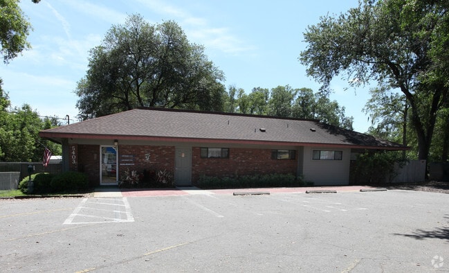
5403 Firestone Rd, Jacksonville, FL 32244


NEARBY LISTINGS FOR SALE OR LEASE
Property Detail
5403 Firestone Rd
014436-0000
Jax Heights Sec
Medicalbuilding
5-93 13-3S-25E .835 JACKSONVILLE HEIGHTS PT TRACT 7 RECD O/R 10956-273 (EX PT R/W RECD O/R 17760-1329) BLK 2
X
Duval
12019C0060E
Florida
2025
0.82 AC
2026
Riverside
013523
Jacksonville (Florida)
3,935 SF
Jacksonville, FL
DEMOGRAPHICS near 5403 Firestone Rd
1 mile
3 mile
5 mile
2024 Total Population
13,215
86,747
193,124
2029 Population
13,808
90,977
203,136
Pop Growth 2024-2029
+ 4.49%
+ 4.88%
+ 5.18%
Average Age
37
37
38
2024 Total Households
4,953
32,870
74,738
HH Growth 2024-2029
+ 4.64%
+ 5.02%
+ 5.30%
Median Household Inc
$48,606
$50,900
$56,705
Avg Household Size
2.60
2.60
2.50
2024 Avg HH Vehicles
2.00
2.00
2.00
Median Home Value
$139,715
$168,519
$195,286
Median Year Built
1981
1983
1983
Nearby Places
Map Layers
Map Styles
 Street
 Aerial
Transit
 Traffic
 Biking
Places
Listings with unknown addresses are not visible on the map
- Restaurants
- Banks
- Shops
- Fitness
- Groceries
PUBLIC TRANSPORTATION
AIRPORT
Jacksonville International
Drive
Walk
Distance
Jacksonville International
31 min
21.8 mi
Freight Ports
Jacksonville Port
Drive
Walk
Distance
Jacksonville Port
24 min
15.6 mi
Nearby Properties
Address
Land Use
TOTAL SIZE
Lot Size
Zoning
Address
Land Use
TOTAL SIZE
Lot Size
Zoning
402,240 SF
20.66 AC
PUD
Address
Land Use
TOTAL SIZE
Lot Size
Zoning
307,960 SF
18.52 AC
PUD
Address
Land Use
TOTAL SIZE
Lot Size
Zoning
375,127 SF
18.65 AC
PUD
Address
Land Use
TOTAL SIZE
Lot Size
Zoning
179,916 SF
12.19 AC
RMD-D
Address
Land Use
TOTAL SIZE
Lot Size
Zoning
188,666 SF
17.76 AC
PUD
Address
Land Use
TOTAL SIZE
Lot Size
Zoning
416,674 SF
18.38 AC
RMD-D
Address
Land Use
TOTAL SIZE
Lot Size
Zoning
203,724 SF
14.71 AC
RMD-D
Address
Land Use
TOTAL SIZE
Lot Size
Zoning
309,137 SF
20.09 AC
RMD-D
Address
Land Use
TOTAL SIZE
Lot Size
Zoning
272,076 SF
54.84 AC
PUD
Address
Land Use
TOTAL SIZE
Lot Size
Zoning
188,578 SF
13.44 AC
RMD-D
Address
Land Use
TOTAL SIZE
Lot Size
Zoning
228,290 SF
12.65 AC
RMD-D
Address
Land Use
TOTAL SIZE
Lot Size
Zoning
277,225 SF
11.72 AC
RMD-D
Address
Land Use
TOTAL SIZE
Lot Size
Zoning
207,697 SF
16.06 AC
PUD
Address
Land Use
TOTAL SIZE
Lot Size
Zoning
96,314 SF
21.05 AC
CCG-1
Address
Land Use
TOTAL SIZE
Lot Size
Zoning
206,513 SF
9.83 AC
RMD-D
Address
Land Use
TOTAL SIZE
Lot Size
Zoning
145,186 SF
47.24 AC
RLD-60
Address
Land Use
TOTAL SIZE
Lot Size
Zoning
231,044 SF
10.94 AC
RMD-D
Address
Land Use
TOTAL SIZE
Lot Size
Zoning
137,636 SF
9.73 AC
RMD-D
Address
Land Use
TOTAL SIZE
Lot Size
Zoning
171,412 SF
16.44 AC
RMD-D
Address
Land Use
TOTAL SIZE
Lot Size
Zoning
169,084 SF
13 AC
CCG-1
Address
Land Use
TOTAL SIZE
Lot Size
Zoning
229,441 SF
17.48 AC
PUD
Address
Land Use
TOTAL SIZE
Lot Size
Zoning
152,768 SF
9.66 AC
RMD-D
Address
Land Use
TOTAL SIZE
Lot Size
Zoning
67,581 SF
24.24 AC
PUD
Address
Land Use
TOTAL SIZE
Lot Size
Zoning
159,337 SF
11.09 AC
RMD-D
Address
Land Use
TOTAL SIZE
Lot Size
Zoning
209,238 SF
10.31 AC
RMD-D
Address
Land Use
TOTAL SIZE
Lot Size
Zoning
193,478 SF
10.13 AC
RMD-D
Address
Land Use
TOTAL SIZE
Lot Size
Zoning
50,150 SF
38.63 AC
RMD-MH
Address
Land Use
TOTAL SIZE
Lot Size
Zoning
160,634 SF
16.36 AC
RMD-D
Address
Land Use
TOTAL SIZE
Lot Size
Zoning
57,762 SF
11.90 AC
CCG-2
Address
Land Use
TOTAL SIZE
Lot Size
Zoning
68,126 SF
36.98 AC
RMD-MH
The World's #1 Commercial Real Estate Marketplace
Connect with us
© 2026 CoStar Group
The information above has been obtained from sources believed reliable. While we do not doubt its accuracy we have not verified it and make no guarantee, warranty or representation about it. It is your responsibility to independently confirm its accuracy and completeness. Any projections, opinions, assumptions, or estimates used are for example only and do not represent the current or future performance of the property. The value of this transaction to you depends on tax and other factors which should be evaluated by your tax, financial, and legal advisors. You and your advisors should conduct a careful, independent investigation of the property to determine to your satisfaction the suitability of the property for your needs.