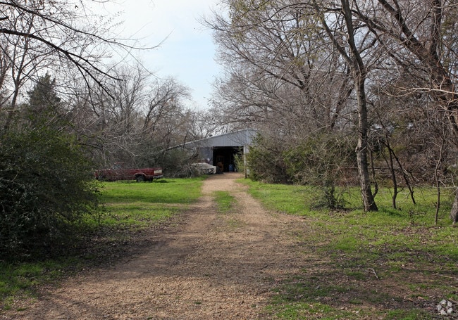
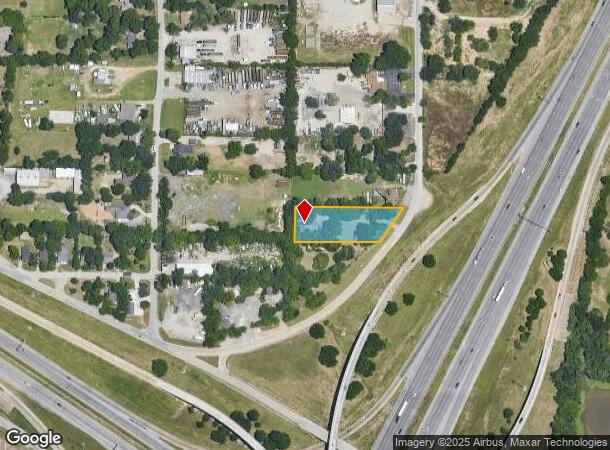
Property Record
5403 S Peachtree Rd, Balch Springs, TX 75180
NEARBY LISTINGS FOR SALE OR LEASE
Property Detail
5403 S Peachtree Rd
Dallas-Fort Worth-Arlington, TX
Buford Jett
12037500020230000
BUFORD JETT BLK 2 PT LOT 23 CO-DALLAS 0375000202300 31203750002
Warehouse
Dallas
X
Texas
48113C0510K
23
2024
0.88 AC
2025
East Dallas/Mesquite
011702
Dallas/Ft Worth
1,428 SF
DEMOGRAPHICS near 5403 S Peachtree Rd
1 Mile
3 Mile
5 Mile
2024 Total Population
3,931
67,566
182,022
2029 Population
3,921
67,376
180,651
Pop Growth 2024-2029
(0.25%)
(0.28%)
(0.75%)
Average Age
34
33
33
2024 Total Households
1,101
18,846
51,027
HH Growth 2024-2029
(0.45%)
(0.41%)
(1.03%)
Median Household Inc
$51,050
$52,492
$49,271
Avg Household Size
3.50
3.50
3.40
2024 Avg HH Vehicles
2.00
2.00
2.00
Median Home Value
$161,797
$172,834
$159,076
Median Year Built
1979
1982
1979
Nearby Places
Map Layers
Map Styles
 Street
 Aerial
- Restaurants
- Banks
- Shops
- Fitness
- Groceries
PUBLIC TRANSPORTATION
AIRPORT
Dallas Love Field
DRIVE
WALK
Distance
Dallas Love Field
27 min
18.0 mi
Dallas-Fort Worth International
DRIVE
WALK
Distance
Dallas-Fort Worth International
42 min
33.9 mi
Freight Ports
Port of Shreveport
DRIVE
WALK
Distance
Port of Shreveport
199 min
185.4 mi
Nearby Properties
Address
Land Use
TOTAL SIZE
Lot Size
Zoning
Address
Land Use
TOTAL SIZE
Lot Size
Zoning
199,246 SF
15.32 AC
Z250
Address
Land Use
TOTAL SIZE
Lot Size
Zoning
257,745 SF
31.54 AC
Z298
Address
Land Use
TOTAL SIZE
Lot Size
Zoning
257,696 SF
9.62 AC
Address
Land Use
TOTAL SIZE
Lot Size
Zoning
372,456 SF
17.34 AC
Z116
Address
Land Use
TOTAL SIZE
Lot Size
Zoning
267,011 SF
11.11 AC
Z250
Address
Land Use
TOTAL SIZE
Lot Size
Zoning
141,566 SF
23 AC
Z298
Address
Land Use
TOTAL SIZE
Lot Size
Zoning
238,728 SF
12.31 AC
Z184
Address
Land Use
TOTAL SIZE
Lot Size
Zoning
234,459 SF
9.71 AC
Z138
Address
Land Use
TOTAL SIZE
Lot Size
Zoning
123,499 SF
8.32 AC
Z239
Address
Land Use
TOTAL SIZE
Lot Size
Zoning
190,150 SF
13.39 AC
Z236
Address
Land Use
TOTAL SIZE
Lot Size
Zoning
118,237 SF
5.56 AC
Z183
Address
Land Use
TOTAL SIZE
Lot Size
Zoning
123,790 SF
6.68 AC
Z183
Address
Land Use
TOTAL SIZE
Lot Size
Zoning
143,713 SF
9.29 AC
Z59
Address
Land Use
TOTAL SIZE
Lot Size
Zoning
160,000 SF
9.60 AC
Z250
Address
Land Use
TOTAL SIZE
Lot Size
Zoning
122,352 SF
6.05 AC
Z46
Address
Land Use
TOTAL SIZE
Lot Size
Zoning
183 SF
23.14 AC
Z06
Address
Land Use
TOTAL SIZE
Lot Size
Zoning
203 SF
23.94 AC
MFA
Address
Land Use
TOTAL SIZE
Lot Size
Zoning
143,880 SF
43.64 AC
Z35
Address
Land Use
TOTAL SIZE
Lot Size
Zoning
96,196 SF
8 AC
Z06
Address
Land Use
TOTAL SIZE
Lot Size
Zoning
81,210 SF
12.91 AC
Z298
Address
Land Use
TOTAL SIZE
Lot Size
Zoning
106,380 SF
15.82 AC
Z139
Address
Land Use
TOTAL SIZE
Lot Size
Zoning
183,094 SF
11.94 AC
Z164
Address
Land Use
TOTAL SIZE
Lot Size
Zoning
217,202 SF
18.50 AC
Z35
Address
Land Use
TOTAL SIZE
Lot Size
Zoning
144,545 SF
7.50 AC
Z164
Address
Land Use
TOTAL SIZE
Lot Size
Zoning
150,207 SF
9 AC
Z236
Address
Land Use
TOTAL SIZE
Lot Size
Zoning
72,341 SF
13 AC
Z236
Address
Land Use
TOTAL SIZE
Lot Size
Zoning
127,328 SF
6.97 AC
Z138
Address
Land Use
TOTAL SIZE
Lot Size
Zoning
191 SF
23.10 AC
Z05
Address
Land Use
TOTAL SIZE
Lot Size
Zoning
130,501 SF
10.37 AC
Z236
Address
Land Use
TOTAL SIZE
Lot Size
Zoning
131,821 SF
8.96 AC
The World's #1 Commercial Real Estate Marketplace
Connect with us
© 2025 CoStar Group
The information above has been obtained from sources believed reliable. While we do not doubt its accuracy we have not verified it and make no guarantee, warranty or representation about it. It is your responsibility to independently confirm its accuracy and completeness. Any projections, opinions, assumptions, or estimates used are for example only and do not represent the current or future performance of the property. The value of this transaction to you depends on tax and other factors which should be evaluated by your tax, financial, and legal advisors. You and your advisors should conduct a careful, independent investigation of the property to determine to your satisfaction the suitability of the property for your needs.